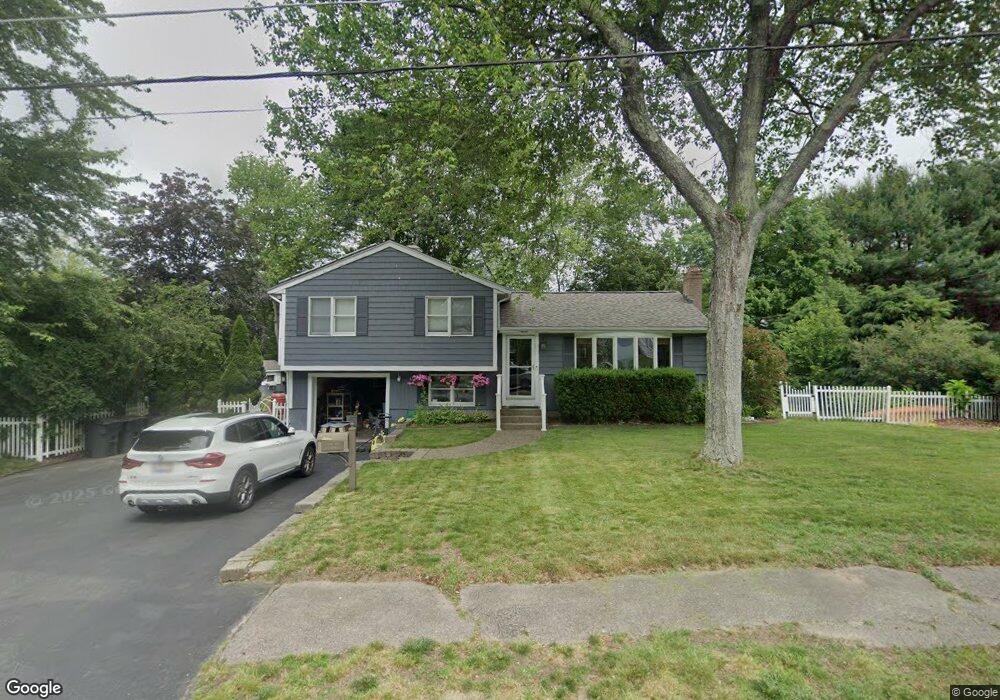
59 Hale Rd East Walpole, MA 02032
Estimated Value: $599,000 - $757,000
3
Beds
2
Baths
1,332
Sq Ft
$499/Sq Ft
Est. Value
About This Home
This home is located at 59 Hale Rd, East Walpole, MA 02032 and is currently estimated at $665,185, approximately $499 per square foot. 59 Hale Rd is a home located in Norfolk County with nearby schools including Old Post Road School, Walpole Middle School, and Walpole High School.
Ownership History
Date
Name
Owned For
Owner Type
Purchase Details
Closed on
Feb 26, 1999
Sold by
Sareault David M and Sareault Susan M
Bought by
Chutoransky Richard E and Chutoransky Lisa A
Current Estimated Value
Purchase Details
Closed on
Dec 29, 1989
Sold by
Cornetta Peter J
Bought by
Sareault David M
Create a Home Valuation Report for This Property
The Home Valuation Report is an in-depth analysis detailing your home's value as well as a comparison with similar homes in the area
Home Values in the Area
Average Home Value in this Area
Purchase History
| Date | Buyer | Sale Price | Title Company |
|---|---|---|---|
| Chutoransky Richard E | $243,000 | -- | |
| Sareault David M | $139,000 | -- |
Source: Public Records
Mortgage History
| Date | Status | Borrower | Loan Amount |
|---|---|---|---|
| Open | Sareault David M | $172,000 | |
| Closed | Sareault David M | $60,000 |
Source: Public Records
Tax History Compared to Growth
Tax History
| Year | Tax Paid | Tax Assessment Tax Assessment Total Assessment is a certain percentage of the fair market value that is determined by local assessors to be the total taxable value of land and additions on the property. | Land | Improvement |
|---|---|---|---|---|
| 2025 | $7,571 | $590,100 | $320,600 | $269,500 |
| 2024 | $7,319 | $553,600 | $308,200 | $245,400 |
| 2023 | $7,102 | $511,300 | $268,000 | $243,300 |
| 2022 | $6,717 | $464,500 | $248,200 | $216,300 |
| 2021 | $6,291 | $423,900 | $234,100 | $189,800 |
| 2020 | $6,261 | $417,700 | $220,900 | $196,800 |
| 2019 | $6,043 | $400,200 | $212,500 | $187,700 |
| 2018 | $5,708 | $373,800 | $204,800 | $169,000 |
| 2017 | $5,519 | $360,000 | $196,800 | $163,200 |
| 2016 | $5,360 | $344,500 | $189,200 | $155,300 |
| 2015 | $4,917 | $313,200 | $163,800 | $149,400 |
| 2014 | $4,703 | $298,400 | $163,800 | $134,600 |
Source: Public Records
Map
Nearby Homes
- Unit 11 Powder House Ln Unit 11
- 8 Powder House Ln Unit 2
- Unit 12 Powder House Ln Unit 12
- Unit 3 Powder House Ln Unit 3
- 11 Park Ln
- 270 Moosehill Rd
- 93 Brewster Dr
- 363 - 367 Washington St
- 0 Charlotte Rd
- 7 Washington Green
- 256 Norwood St
- 486 Washington St
- 1 Palace Ct
- 26 Bullard St
- 38 Cape Club Dr Unit 38
- 40 Cape Club Dr Unit 40
- 30 Bullard St
- 2 Alexandra Way
- 10 Cobbler Ln
- 20 Rockhill St