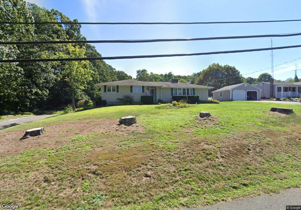
59 Kirby Rd Westport, MA 02790
Booth/Handy Four Corners NeighborhoodEstimated Value: $565,000 - $657,000
3
Beds
--
Bath
1,813
Sq Ft
$337/Sq Ft
Est. Value
About This Home
This home is located at 59 Kirby Rd, Westport, MA 02790 and is currently estimated at $611,121, approximately $337 per square foot. 59 Kirby Rd is a home located in Bristol County with nearby schools including Alice A. Macomber Primary School, Westport Elementary School, and Westport Middle-High School.
Ownership History
Date
Name
Owned For
Owner Type
Purchase Details
Closed on
Aug 11, 2017
Sold by
Mcquoid Connie M and Mcquoid William
Bought by
Mcquoid William and Mcquoid Connie M
Current Estimated Value
Purchase Details
Closed on
May 12, 1972
Bought by
Mcquoid William and Mcquoid Connie M
Create a Home Valuation Report for This Property
The Home Valuation Report is an in-depth analysis detailing your home's value as well as a comparison with similar homes in the area
Home Values in the Area
Average Home Value in this Area
Purchase History
| Date | Buyer | Sale Price | Title Company |
|---|---|---|---|
| Mcquoid William | -- | -- | |
| Mcquoid William | -- | -- |
Source: Public Records
Mortgage History
| Date | Status | Borrower | Loan Amount |
|---|---|---|---|
| Previous Owner | Mcquoid William | $50,000 |
Source: Public Records
Tax History Compared to Growth
Tax History
| Year | Tax Paid | Tax Assessment Tax Assessment Total Assessment is a certain percentage of the fair market value that is determined by local assessors to be the total taxable value of land and additions on the property. | Land | Improvement |
|---|---|---|---|---|
| 2025 | $3,415 | $458,400 | $198,100 | $260,300 |
| 2024 | $3,403 | $440,200 | $183,500 | $256,700 |
| 2023 | $3,160 | $387,200 | $154,600 | $232,600 |
| 2022 | $2,988 | $352,400 | $154,600 | $197,800 |
| 2021 | $2,917 | $338,400 | $140,600 | $197,800 |
| 2020 | $2,756 | $326,900 | $129,100 | $197,800 |
| 2019 | $2,602 | $314,600 | $117,300 | $197,300 |
| 2018 | $1,199 | $299,200 | $116,300 | $182,900 |
| 2017 | $2,326 | $291,800 | $112,600 | $179,200 |
| 2016 | $2,148 | $271,600 | $108,900 | $162,700 |
| 2015 | $2,022 | $255,000 | $111,400 | $143,600 |
Source: Public Records
Map
Nearby Homes
- 7 Village Way
- 8 Village Way
- 15 Village Way
- 837 Main Rd
- 8 Strawberry Ln
- 118 Charlotte White Rd Extension
- 920 Drift Rd
- 0 Hidden Glen Ln
- 225 Hixbridge Rd
- 101 Adamsville Rd
- 118 Charlotte White Rd
- Lot 0 Marcotte
- 978 Sodom Rd
- 47 Fallon Dr
- 73 White Oak Run
- 1346 Main Rd Unit B
- 4 Main Rd
- 6 Angel Ct
- 99 Sylvia Ln
- 17 Quail Trail