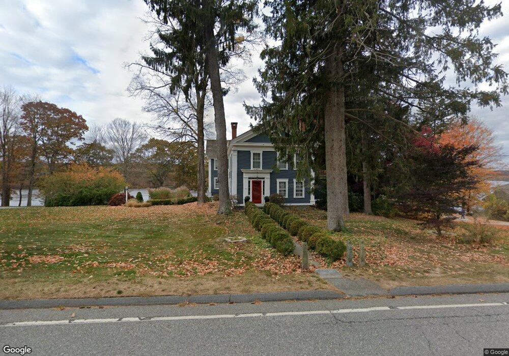
59 Main St East Haddam, CT 06423
Estimated Value: $1,108,000 - $2,158,139
4
Beds
5
Baths
5,828
Sq Ft
$247/Sq Ft
Est. Value
About This Home
This home is located at 59 Main St, East Haddam, CT 06423 and is currently estimated at $1,441,785, approximately $247 per square foot. 59 Main St is a home located in Middlesex County with nearby schools including East Haddam Elementary School, Nathan Hale-Ray Middle School, and Nathan Hale-Ray High School.
Ownership History
Date
Name
Owned For
Owner Type
Purchase Details
Closed on
May 24, 2024
Sold by
Gionta Tracey F
Bought by
Tracey F Gionta T F and Tracey Gionta
Current Estimated Value
Purchase Details
Closed on
Nov 9, 2000
Sold by
Bernstein Myron R
Bought by
Gionta Michael and Gionta Tracey F
Purchase Details
Closed on
Nov 17, 1997
Sold by
Bernstein Myron R
Bought by
Cooney Caroline B
Create a Home Valuation Report for This Property
The Home Valuation Report is an in-depth analysis detailing your home's value as well as a comparison with similar homes in the area
Home Values in the Area
Average Home Value in this Area
Purchase History
| Date | Buyer | Sale Price | Title Company |
|---|---|---|---|
| Tracey F Gionta T F | -- | None Available | |
| Tracey F Gionta T F | -- | None Available | |
| Gionta Michael | $500,000 | -- | |
| Cooney Caroline B | $225,000 | -- | |
| Gionta Michael | $500,000 | -- |
Source: Public Records
Mortgage History
| Date | Status | Borrower | Loan Amount |
|---|---|---|---|
| Previous Owner | Cooney Caroline B | $750,000 | |
| Previous Owner | Cooney Caroline B | $860,000 | |
| Previous Owner | Cooney Caroline B | $800,000 |
Source: Public Records
Tax History Compared to Growth
Tax History
| Year | Tax Paid | Tax Assessment Tax Assessment Total Assessment is a certain percentage of the fair market value that is determined by local assessors to be the total taxable value of land and additions on the property. | Land | Improvement |
|---|---|---|---|---|
| 2025 | $25,200 | $898,070 | $277,940 | $620,130 |
| 2024 | $24,032 | $898,070 | $277,940 | $620,130 |
| 2023 | $23,125 | $898,070 | $277,940 | $620,130 |
| 2022 | $18,910 | $594,830 | $137,870 | $456,960 |
| 2021 | $18,107 | $594,830 | $137,870 | $456,960 |
| 2020 | $18,107 | $594,830 | $137,870 | $456,960 |
| 2019 | $18,107 | $594,830 | $137,870 | $456,960 |
| 2018 | $17,643 | $594,830 | $137,870 | $456,960 |
| 2017 | $18,033 | $609,640 | $179,280 | $430,360 |
| 2016 | $17,893 | $609,640 | $179,280 | $430,360 |
| 2015 | $17,484 | $609,640 | $179,280 | $430,360 |
| 2014 | $17,011 | $609,700 | $179,340 | $430,360 |
Source: Public Records
Map
Nearby Homes
- 77 Main St
- 23 Main St
- 2 Norwich Rd
- 1572 Saybrook Rd
- 2 Morgan Ln
- 00 Mount Parnassus Rd
- 40 & 42 Old Cart Rd
- 10 Orchard Rd
- 16 Mount Parnassus Rd
- 80 Orchard Rd
- 288 Middlesex Ave
- 428 Plains Rd
- 55 Bogel Rd
- 45 Alger Rd
- 2 Acorn Dr
- 53 Shanaghans Rd
- 5 Joe Williams Rd
- 398 E Haddam Moodus Rd
- 72 Dickinson Rd
- 60 Goose Hill Rd