Estimated Value: $590,782 - $727,000
5
Beds
1
Bath
1,808
Sq Ft
$368/Sq Ft
Est. Value
About This Home
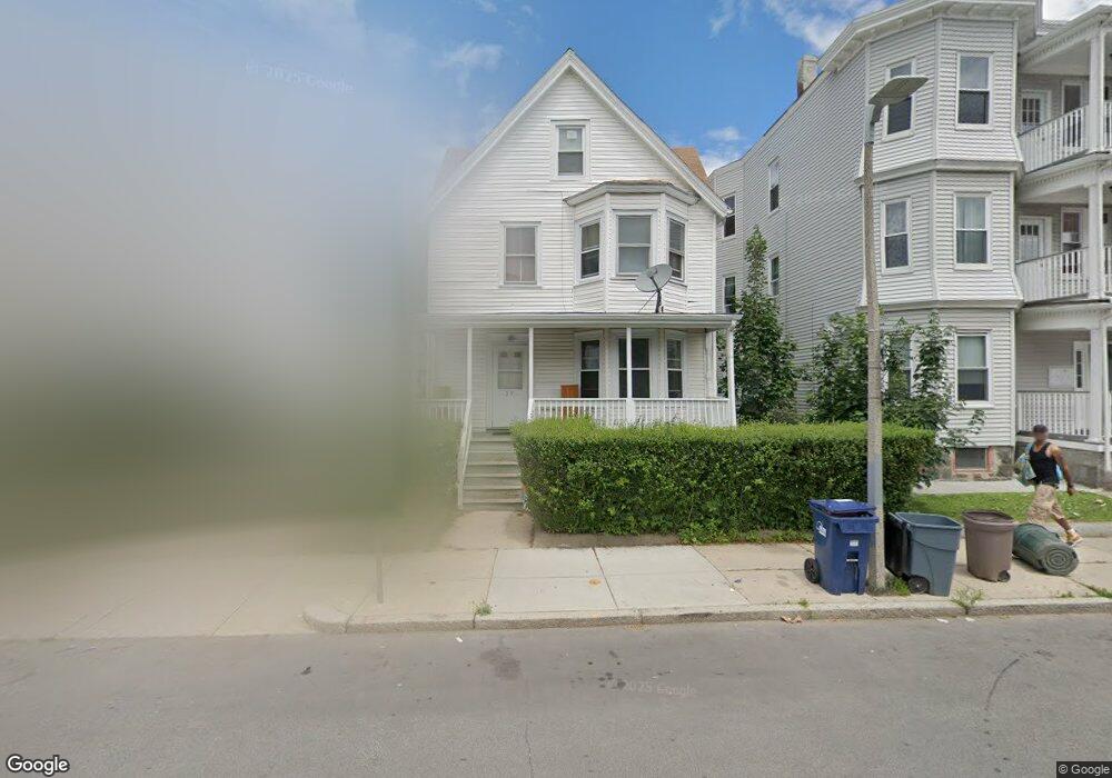
This home is located at 59 Olney St, Dorchester, MA 02121 and is currently estimated at $665,446, approximately $368 per square foot. 59 Olney St is a home located in Suffolk County with nearby schools including UP Academy Charter School of Dorchester and Uncommon Schools Roxbury Prep Dorchester Campus.
Ownership History
Date
Name
Owned For
Owner Type
Purchase Details
Closed on
May 18, 1988
Sold by
Govan Noreen A
Bought by
Lawson Jeremiah
Current Estimated Value
Home Financials for this Owner
Home Financials are based on the most recent Mortgage that was taken out on this home.
Original Mortgage
$130,500
Interest Rate
10.13%
Mortgage Type
Purchase Money Mortgage
Create a Home Valuation Report for This Property
The Home Valuation Report is an in-depth analysis detailing your home's value as well as a comparison with similar homes in the area
Home Values in the Area
Average Home Value in this Area
Purchase History
| Date | Buyer | Sale Price | Title Company |
|---|---|---|---|
| Lawson Jeremiah | $145,000 | -- |
Source: Public Records
Mortgage History
| Date | Status | Borrower | Loan Amount |
|---|---|---|---|
| Open | Lawson Jeremiah | $235,900 | |
| Closed | Lawson Jeremiah | $173,600 | |
| Closed | Lawson Jeremiah | $150,000 | |
| Closed | Lawson Jeremiah | $130,500 |
Source: Public Records
Tax History Compared to Growth
Tax History
| Year | Tax Paid | Tax Assessment Tax Assessment Total Assessment is a certain percentage of the fair market value that is determined by local assessors to be the total taxable value of land and additions on the property. | Land | Improvement |
|---|---|---|---|---|
| 2025 | $4,418 | $381,500 | $176,100 | $205,400 |
| 2024 | $4,146 | $380,400 | $191,600 | $188,800 |
| 2023 | $4,085 | $380,400 | $191,600 | $188,800 |
| 2022 | $3,833 | $352,300 | $177,500 | $174,800 |
| 2021 | $3,533 | $331,100 | $172,300 | $158,800 |
| 2020 | $3,167 | $299,900 | $159,300 | $140,600 |
| 2019 | $2,982 | $282,900 | $131,200 | $151,700 |
| 2018 | $2,770 | $264,300 | $131,200 | $133,100 |
| 2017 | $2,617 | $247,100 | $131,200 | $115,900 |
| 2016 | $2,718 | $247,100 | $131,200 | $115,900 |
| 2015 | $2,128 | $175,700 | $89,200 | $86,500 |
| 2014 | $2,116 | $168,200 | $89,200 | $79,000 |
Source: Public Records
Map
Nearby Homes
- 1 Rock Terrace Unit 1
- 1 Rock Terrace Unit 3
- 1 Dever St
- 139 Bowdoin St
- 51 Hamilton St Unit 3
- 70 Hamilton St
- 76 Bellevue St
- 70-72 Clarkson St
- 20 Rosseter St
- 41 Holiday St
- 60 Stanley St Unit 301
- 60 Stanley St Unit 302
- 60 Stanley St
- 60 Stanley St Unit 101
- 52 Bellevue St Unit 1
- 52 Bellevue St Unit 3
- 52 Bellevue St Unit 2
- 15 Ellington St
- 154 Stanwood St
- 19 Mount Ida Rd
- 61 Olney St
- 57 Olney St
- 57 Olney St Unit 1
- 57 Olney St Unit 3
- 63 Olney St
- 55 Olney St
- 1 Rock Terrace Unit 2
- 53 Olney St
- 53 Olney St Unit 2
- 58 Olney St
- 49 Olney St
- 49 Olney St Unit 1
- 49 Olney St Unit First Floor Apartmen
- 68 Olney St
- 68 Olney St Unit 3
- 5 Rock Terrace
- 2 Rock Terrace
- 60 Olney St Unit 62
- 72 Olney St
- 72 Olney St Unit 1