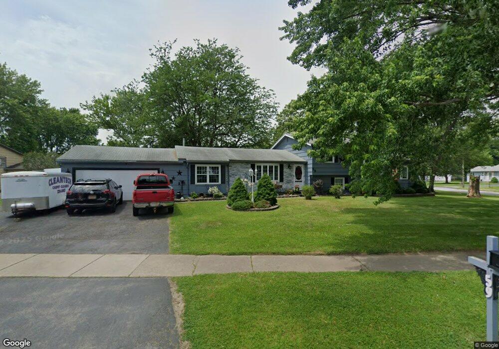
59 Rusty Ln Rochester, NY 14626
Estimated Value: $278,000 - $351,000
4
Beds
2
Baths
2,502
Sq Ft
$124/Sq Ft
Est. Value
About This Home
This home is located at 59 Rusty Ln, Rochester, NY 14626 and is currently estimated at $309,164, approximately $123 per square foot. 59 Rusty Ln is a home located in Monroe County with nearby schools including Autumn Lane Elementary School, Greece Community Early Learning Center, and Craig Hill Elementary School.
Ownership History
Date
Name
Owned For
Owner Type
Purchase Details
Closed on
Mar 13, 1997
Current Estimated Value
Purchase Details
Closed on
Jan 9, 1996
Sold by
Simeone Anthony
Bought by
Martin James and Martin Ann Marie
Purchase Details
Closed on
Oct 12, 1994
Sold by
First Union Home Equity C
Bought by
Simeone Anthony
Purchase Details
Closed on
Aug 5, 1994
Sold by
Palmeri Virginia L
Bought by
First Union Home Equity C
Create a Home Valuation Report for This Property
The Home Valuation Report is an in-depth analysis detailing your home's value as well as a comparison with similar homes in the area
Home Values in the Area
Average Home Value in this Area
Purchase History
| Date | Buyer | Sale Price | Title Company |
|---|---|---|---|
| -- | -- | -- | |
| Martin James | $114,900 | -- | |
| Simeone Anthony | $79,000 | -- | |
| First Union Home Equity C | $80,687 | -- |
Source: Public Records
Tax History Compared to Growth
Tax History
| Year | Tax Paid | Tax Assessment Tax Assessment Total Assessment is a certain percentage of the fair market value that is determined by local assessors to be the total taxable value of land and additions on the property. | Land | Improvement |
|---|---|---|---|---|
| 2024 | $8,339 | $184,600 | $25,700 | $158,900 |
| 2023 | $7,695 | $184,600 | $25,700 | $158,900 |
| 2022 | $6,792 | $152,000 | $28,500 | $123,500 |
| 2021 | $6,770 | $152,000 | $28,500 | $123,500 |
| 2020 | $6,056 | $152,000 | $28,500 | $123,500 |
| 2019 | $1,787 | $152,000 | $28,500 | $123,500 |
| 2018 | $5,332 | $135,500 | $28,500 | $107,000 |
| 2017 | $2,557 | $135,500 | $28,500 | $107,000 |
| 2016 | $5,240 | $135,500 | $28,500 | $107,000 |
| 2015 | -- | $135,500 | $28,500 | $107,000 |
| 2014 | -- | $135,500 | $28,500 | $107,000 |
Source: Public Records
Map
Nearby Homes
- 60 Cindy Ln
- 573 Harvest Dr
- 80 Alecia Dr
- 513 Harvest Dr
- 113 Cindy Ln
- 50 Ballad Ave
- 49 Mathew Ln
- 67 Mill Run Dr
- 159 Charit Way
- 31 Holly Sue Ln
- 275 Barmont Dr
- 125 Barmont Dr
- 76 Creekwood Dr
- 135 Pepperidge Dr
- 16 Flower Dale Dr
- 108 Running Brook Ln
- 41 Running Brook Ln
- 118 Letchworth Ave
- 31 Blue Grass Ln
- 361 Guinevere Dr