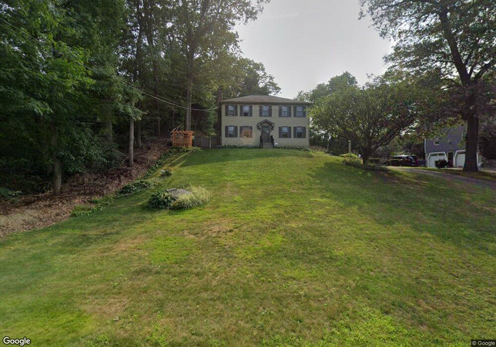
59 Spring St Millis, MA 02054
Estimated Value: $659,895 - $788,000
4
Beds
2
Baths
1,926
Sq Ft
$367/Sq Ft
Est. Value
About This Home
This home is located at 59 Spring St, Millis, MA 02054 and is currently estimated at $707,474, approximately $367 per square foot. 59 Spring St is a home located in Norfolk County with nearby schools including Clyde F Brown, Millis Middle School, and Millis High School.
Ownership History
Date
Name
Owned For
Owner Type
Purchase Details
Closed on
Jun 25, 1999
Sold by
Scire Michael X and Scire Patricia A
Bought by
Maines Ii Donald J and Maines Kathleen
Current Estimated Value
Home Financials for this Owner
Home Financials are based on the most recent Mortgage that was taken out on this home.
Original Mortgage
$219,900
Outstanding Balance
$58,186
Interest Rate
7.09%
Mortgage Type
Purchase Money Mortgage
Estimated Equity
$649,288
Create a Home Valuation Report for This Property
The Home Valuation Report is an in-depth analysis detailing your home's value as well as a comparison with similar homes in the area
Home Values in the Area
Average Home Value in this Area
Purchase History
| Date | Buyer | Sale Price | Title Company |
|---|---|---|---|
| Maines Ii Donald J | $239,900 | -- |
Source: Public Records
Mortgage History
| Date | Status | Borrower | Loan Amount |
|---|---|---|---|
| Open | Maines Ii Donald J | $45,000 | |
| Closed | Maines Ii Donald J | $45,000 | |
| Open | Maines Ii Donald J | $219,900 |
Source: Public Records
Tax History
| Year | Tax Paid | Tax Assessment Tax Assessment Total Assessment is a certain percentage of the fair market value that is determined by local assessors to be the total taxable value of land and additions on the property. | Land | Improvement |
|---|---|---|---|---|
| 2025 | $8,751 | $533,600 | $234,600 | $299,000 |
| 2024 | $8,172 | $497,700 | $216,500 | $281,200 |
| 2023 | $7,848 | $448,700 | $172,600 | $276,100 |
| 2022 | $7,990 | $423,200 | $185,200 | $238,000 |
| 2021 | $7,436 | $379,000 | $160,100 | $218,900 |
| 2020 | $7,262 | $360,600 | $149,600 | $211,000 |
| 2019 | $6,495 | $347,300 | $136,600 | $210,700 |
| 2018 | $6,258 | $347,300 | $136,600 | $210,700 |
| 2017 | $5,681 | $308,400 | $117,300 | $191,100 |
| 2016 | $5,378 | $308,400 | $117,300 | $191,100 |
| 2015 | $5,243 | $308,400 | $117,300 | $191,100 |
Source: Public Records
Map
Nearby Homes
- 57 Spring St
- 75 Spring St
- 68 Spring St Unit 68
- 4 Greenwood Dr
- 72 Spring St
- 77 Spring St
- 6 Greenwood Dr
- 80 Spring St Unit 82
- 45 Spring St
- 1 Greenwood Dr
- 8 Greenwood Dr
- 84 Spring St Unit 86
- 35 Spring St
- 38 Spring St
- 5 Lot 5 Greenwood Dr
- 3 Greenwood Dr
- 10 Greenwood Dr
- 101 Spring St
- 100 Spring St
- 17 Spring St
Your Personal Tour Guide
Ask me questions while you tour the home.