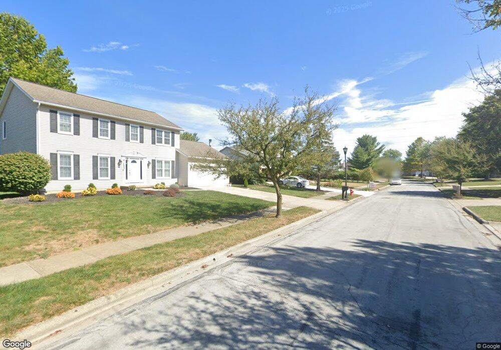
590 Apple St Westerville, OH 43082
Estimated Value: $456,000 - $488,000
4
Beds
3
Baths
2,571
Sq Ft
$183/Sq Ft
Est. Value
About This Home
This home is located at 590 Apple St, Westerville, OH 43082 and is currently estimated at $470,426, approximately $182 per square foot. 590 Apple St is a home located in Delaware County with nearby schools including Robert Frost Elementary School, Heritage Middle School, and Westerville-North High School.
Ownership History
Date
Name
Owned For
Owner Type
Purchase Details
Closed on
Jan 28, 2021
Sold by
Dong Jimmy and Dong Candice H
Bought by
Dupee Steven and Irelan Monica
Current Estimated Value
Home Financials for this Owner
Home Financials are based on the most recent Mortgage that was taken out on this home.
Original Mortgage
$333,450
Outstanding Balance
$296,870
Interest Rate
2.7%
Mortgage Type
New Conventional
Estimated Equity
$173,556
Purchase Details
Closed on
Oct 9, 2000
Sold by
Meyer Rickie D
Bought by
Dong Jimmy
Home Financials for this Owner
Home Financials are based on the most recent Mortgage that was taken out on this home.
Original Mortgage
$189,776
Interest Rate
7.99%
Mortgage Type
FHA
Create a Home Valuation Report for This Property
The Home Valuation Report is an in-depth analysis detailing your home's value as well as a comparison with similar homes in the area
Home Values in the Area
Average Home Value in this Area
Purchase History
| Date | Buyer | Sale Price | Title Company |
|---|---|---|---|
| Dupee Steven | $351,000 | Amerititle | |
| Dupee Steven | $351,000 | Amerititle | |
| Dong Jimmy | $189,900 | -- |
Source: Public Records
Mortgage History
| Date | Status | Borrower | Loan Amount |
|---|---|---|---|
| Open | Dupee Steven | $333,450 | |
| Closed | Dupee Steven | $333,450 | |
| Previous Owner | Dong Jimmy | $189,776 |
Source: Public Records
Tax History
| Year | Tax Paid | Tax Assessment Tax Assessment Total Assessment is a certain percentage of the fair market value that is determined by local assessors to be the total taxable value of land and additions on the property. | Land | Improvement |
|---|---|---|---|---|
| 2024 | $7,053 | $138,430 | $29,400 | $109,030 |
| 2023 | $6,972 | $138,430 | $29,400 | $109,030 |
| 2022 | $6,294 | $96,680 | $20,130 | $76,550 |
| 2021 | $6,348 | $96,680 | $20,130 | $76,550 |
| 2020 | $6,390 | $96,680 | $20,130 | $76,550 |
| 2019 | $5,516 | $79,730 | $17,500 | $62,230 |
| 2018 | $5,423 | $79,730 | $17,500 | $62,230 |
| 2017 | $5,422 | $76,970 | $12,740 | $64,230 |
| 2016 | $5,712 | $76,970 | $12,740 | $64,230 |
| 2015 | $5,464 | $76,970 | $12,740 | $64,230 |
| 2014 | $5,518 | $76,970 | $12,740 | $64,230 |
| 2013 | $5,260 | $73,330 | $12,740 | $60,590 |
Source: Public Records
Map
Nearby Homes
- 478 Burns Dr N
- 222 Juniper Ave
- 660 Albion Place Unit 8660
- 393 Canterbury Ct
- 373 Wyndham Park S
- 192 Sassafras Way
- 570 Susan Ave
- 629 Andrew Ave
- 787 Centerpark Dr
- 339 Aylesbury Dr S
- 403 Windemere Cir Unit 403
- 852 Karen Ct
- 303 Pointe Place
- 266 Black Walnut Dr
- 329 Hampton Park
- 687 E College Ave
- 62 College Place
- 328 Myrtle Dr Unit Lot 5
- 348 Myrtle Dr Unit Lot 10
- 337 Myrtle Dr Unit Lot 2
Your Personal Tour Guide
Ask me questions while you tour the home.