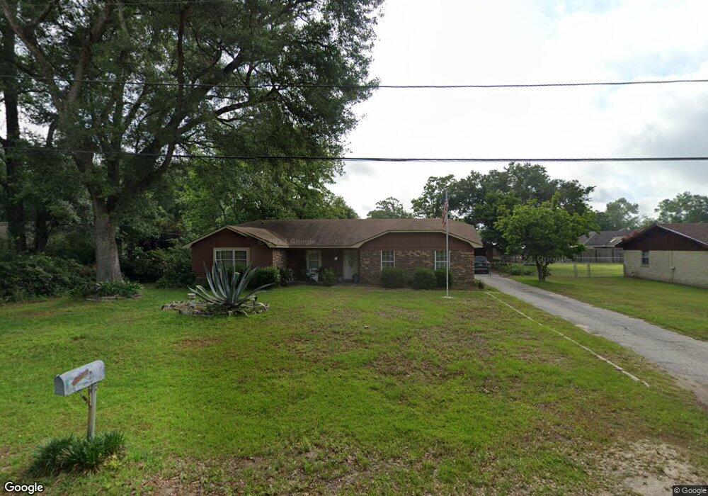
5900 Twin Branch Dr E Satsuma, AL 36572
Estimated Value: $233,670 - $294,000
3
Beds
2
Baths
1,876
Sq Ft
$143/Sq Ft
Est. Value
About This Home
This home is located at 5900 Twin Branch Dr E, Satsuma, AL 36572 and is currently estimated at $267,918, approximately $142 per square foot. 5900 Twin Branch Dr E is a home located in Mobile County with nearby schools including Robert E. Lee Elementary School, Satsuma High School, and Satsuma Christian School.
Ownership History
Date
Name
Owned For
Owner Type
Purchase Details
Closed on
May 22, 2015
Sold by
Hensarling James S
Bought by
Hensarling James S and Hensarling Charlotte D
Current Estimated Value
Purchase Details
Closed on
May 26, 2010
Sold by
West Niccole
Bought by
Hensarling James S
Purchase Details
Closed on
Apr 20, 2010
Sold by
Hensarling Peggy C
Bought by
Hensarling James S
Purchase Details
Closed on
Nov 13, 2000
Sold by
Hensarling James M
Bought by
Hensarling James S
Create a Home Valuation Report for This Property
The Home Valuation Report is an in-depth analysis detailing your home's value as well as a comparison with similar homes in the area
Home Values in the Area
Average Home Value in this Area
Purchase History
| Date | Buyer | Sale Price | Title Company |
|---|---|---|---|
| Hensarling James S | -- | None Available | |
| Hensarling James S | -- | None Available | |
| Hensarling James S | -- | None Available | |
| Hensarling James S | -- | -- |
Source: Public Records
Tax History Compared to Growth
Tax History
| Year | Tax Paid | Tax Assessment Tax Assessment Total Assessment is a certain percentage of the fair market value that is determined by local assessors to be the total taxable value of land and additions on the property. | Land | Improvement |
|---|---|---|---|---|
| 2024 | -- | $18,310 | $3,500 | $14,810 |
| 2023 | $0 | $16,990 | $3,500 | $13,490 |
| 2022 | $0 | $15,670 | $3,500 | $12,170 |
| 2021 | $1,619 | $13,610 | $3,500 | $10,110 |
| 2020 | $1,619 | $13,510 | $2,700 | $10,810 |
| 2019 | $1,619 | $26,540 | $0 | $0 |
| 2018 | $1,516 | $24,860 | $0 | $0 |
| 2017 | $1,560 | $25,580 | $0 | $0 |
| 2016 | $1,590 | $26,060 | $0 | $0 |
| 2013 | $621 | $11,060 | $0 | $0 |
Source: Public Records
Map
Nearby Homes
- 5901 Vaughn Dr W
- 459 Daphne V St
- 550 Vaughn Dr S
- 567 Vaughn Dr S
- 6158 Granada Ave
- 571 Margiana Dr
- 211 Magnolia Ave
- 6453 Gilbert Dr W
- 0 Baldwin Rd Unit 2 374664
- 0 Baldwin Rd
- 5859 Northgate Dr W
- 0 Travelers Ct Unit 34 315632
- 207 Maple Ave E
- 150 Orange Ave E
- 0 Kalifield Blvd Unit 25 384900
- 0 Kalifield Blvd Unit 7646196
- 5303 U S 43
- 5454 3rd St
- 0 I-65 Service Rd S
- 5509 Darring St
- 5904 Twin Branch Dr E
- 5862 Twin Branch Dr E
- 5858 Twin Branch Dr E
- 5905 Vaughn Dr W
- 5908 Twin Branch Dr E
- 5901 Twin Branch Dr E
- 450 Vaughn Dr S
- 5859 Vaughn Dr W
- 5909 Twin Branch Dr E
- 404 Teakwood Dr
- 5854 Twin Branch Dr E
- 452 Vaughn Dr S
- 401 Teakwood Dr
- 400 Vaughn Dr S
- 5851 Vaughn Dr W
- 5951 Harrison Dr
- 400 Teakwood Dr
- 451 Charles V St
- 5850 Twin Branch Dr E
- 409 Vaughn Dr S