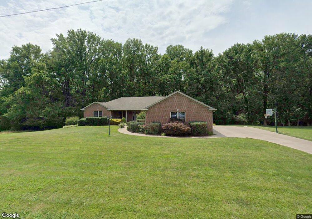
5901 Hausman Rd Mount Vernon, IN 47620
Estimated Value: $416,000 - $513,387
4
Beds
4
Baths
2,018
Sq Ft
$225/Sq Ft
Est. Value
About This Home
This home is located at 5901 Hausman Rd, Mount Vernon, IN 47620 and is currently estimated at $454,597, approximately $225 per square foot. 5901 Hausman Rd is a home located in Posey County with nearby schools including Mount Vernon Junior High School, Mount Vernon High School, and St. Philip School.
Ownership History
Date
Name
Owned For
Owner Type
Purchase Details
Closed on
Jun 29, 2006
Sold by
C & M Greenwell Contracting Llc
Bought by
Gray Morris and Gray Mary K
Current Estimated Value
Home Financials for this Owner
Home Financials are based on the most recent Mortgage that was taken out on this home.
Original Mortgage
$207,000
Outstanding Balance
$126,531
Interest Rate
6.72%
Mortgage Type
New Conventional
Estimated Equity
$328,066
Create a Home Valuation Report for This Property
The Home Valuation Report is an in-depth analysis detailing your home's value as well as a comparison with similar homes in the area
Home Values in the Area
Average Home Value in this Area
Purchase History
| Date | Buyer | Sale Price | Title Company |
|---|---|---|---|
| Gray Morris | -- | None Available |
Source: Public Records
Mortgage History
| Date | Status | Borrower | Loan Amount |
|---|---|---|---|
| Open | Gray Morris | $207,000 |
Source: Public Records
Tax History Compared to Growth
Tax History
| Year | Tax Paid | Tax Assessment Tax Assessment Total Assessment is a certain percentage of the fair market value that is determined by local assessors to be the total taxable value of land and additions on the property. | Land | Improvement |
|---|---|---|---|---|
| 2024 | $3,823 | $432,900 | $41,700 | $391,200 |
| 2023 | $3,387 | $397,900 | $38,600 | $359,300 |
| 2022 | $2,802 | $324,800 | $27,300 | $297,500 |
| 2021 | $2,424 | $281,300 | $29,900 | $251,400 |
| 2020 | $2,404 | $275,200 | $29,300 | $245,900 |
| 2019 | $2,296 | $267,300 | $28,200 | $239,100 |
| 2018 | $2,213 | $264,600 | $27,700 | $236,900 |
| 2017 | $2,040 | $259,500 | $27,700 | $231,800 |
| 2016 | $1,931 | $257,100 | $27,700 | $229,400 |
| 2014 | $1,987 | $272,300 | $32,400 | $239,900 |
| 2013 | $1,987 | $270,600 | $31,000 | $239,600 |
Source: Public Records
Map
Nearby Homes
- 5225 Star Dr
- 10900 Woodside Dr S
- 10311 Eastgate Dr S
- 0 Fox Ridge Rd
- 5015 Alysia St
- 11314 Vixen Dr
- 6855 Lakeside Ln
- 5900 Serenity Dr
- 9205 Amber Ln
- 4031 Saint Phillips Rd S
- 9051 Middle Mount Vernon Rd
- 2646 Marycrest Dr
- 2734 Marycrest Dr
- Little Rock Craftsman Plan at Westridge Commons
- Revolution Craftsman Plan at Westridge Commons
- Revolution Farmhouse Plan at Westridge Commons
- Walnut Craftsman Plan at Westridge Commons
- Patriot Modern Plan at Westridge Commons
- National Farmhouse Plan at Westridge Commons
- Cumberland Farmhouse 3-Car Plan at Westridge Commons
- 5825 Hausman Rd
- 10500 Wolfinger Rd Unit 7
- 10500 Wolfinger Rd
- 5900 Hausman Rd
- 5820 Hausman Rd
- 10420 Wolfinger Rd
- 5815 Hausman Rd
- 10425 Wolfinger Rd
- 5810 Hausman Rd
- 10511 Wolfinger Rd
- 10410 Wolfinger Rd
- 5801 Hausman Rd
- 10539 Wolfinger Rd
- 10540 Wolfinger Rd
- 10400 Wolfinger Rd
- 10415 Wolfinger Rd
- 5900 Saint Charles Dr
- 5749 Hausmann Rd
- 5800 Saint Charles Dr
- 10601 Wolfinger Rd