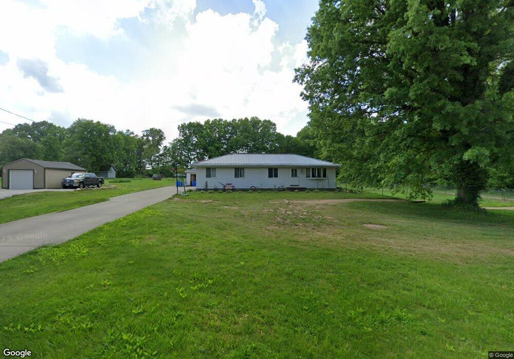
5902 Weaver Rd Clinton, OH 44216
Estimated Value: $227,000 - $240,399
4
Beds
2
Baths
1,352
Sq Ft
$172/Sq Ft
Est. Value
About This Home
This home is located at 5902 Weaver Rd, Clinton, OH 44216 and is currently estimated at $232,600, approximately $172 per square foot. 5902 Weaver Rd is a home located in Summit County with nearby schools including Nolley Elementary School, Manchester Middle School, and Manchester High School.
Ownership History
Date
Name
Owned For
Owner Type
Purchase Details
Closed on
Nov 30, 2013
Sold by
Miller Donald William and Miller Wilma Eva
Bought by
Crabtree James R and Crabtree Amanda N
Current Estimated Value
Purchase Details
Closed on
Mar 15, 1999
Sold by
Miller Donald William and Miller Wilma Eva
Bought by
Miller Donald William and Miller Wilma Eva
Create a Home Valuation Report for This Property
The Home Valuation Report is an in-depth analysis detailing your home's value as well as a comparison with similar homes in the area
Home Values in the Area
Average Home Value in this Area
Purchase History
| Date | Buyer | Sale Price | Title Company |
|---|---|---|---|
| Crabtree James R | $118,000 | None Available | |
| Miller Donald William | -- | -- |
Source: Public Records
Tax History
| Year | Tax Paid | Tax Assessment Tax Assessment Total Assessment is a certain percentage of the fair market value that is determined by local assessors to be the total taxable value of land and additions on the property. | Land | Improvement |
|---|---|---|---|---|
| 2024 | $3,367 | $67,438 | $16,828 | $50,610 |
| 2023 | $3,367 | $67,438 | $16,828 | $50,610 |
| 2022 | $3,115 | $48,594 | $11,935 | $36,659 |
| 2021 | $3,126 | $48,594 | $11,935 | $36,659 |
| 2020 | $3,072 | $48,600 | $11,940 | $36,660 |
| 2019 | $3,377 | $47,880 | $9,770 | $38,110 |
| 2018 | $2,914 | $47,880 | $9,770 | $38,110 |
| 2017 | $2,834 | $47,880 | $9,770 | $38,110 |
| 2016 | $2,801 | $42,210 | $9,770 | $32,440 |
| 2015 | $2,834 | $42,210 | $9,770 | $32,440 |
| 2014 | $2,813 | $42,210 | $9,770 | $32,440 |
| 2013 | $2,234 | $42,430 | $9,770 | $32,660 |
Source: Public Records
Map
Nearby Homes
- 5766 Weaver Rd
- 6407 Southview Dr
- 6235 Manchester Rd
- 6090 Manchester Rd Unit 6096
- 771 Leeman Dr
- 715 Highland Park Dr
- 0 W Comet Rd Unit 5079117
- 477 Deborah Dr
- 5743 Brookwood Dr
- 5042 Laddie Dr
- 427 Catalina Dr
- 0 Babst Ave NW
- 6 Shrakes Hotel Dr
- 4 Shrakes Hotel Dr
- 8499 Sherri Ave NW
- 7 Shrakes Hotel Dr
- 5 Shrakes Hotel Dr
- 3 Shrakes Hotel Dr
- 8690 Elmfield St NW
- 8257 Akron Ave NW
- v/l Weaver Rd
- 5920 Weaver Rd
- 5912 Weaver Rd
- 5913 Weaver Rd
- 5923 Weaver Rd
- 5930 Weaver Rd
- 5869 Weaver Rd
- 5872 Weaver Rd
- 5943 Weaver Rd
- 5940 Weaver Rd
- 442 S Messner Rd
- 452 S Messner Rd
- 424 S Messner Rd
- 412 S Messner Rd
- 462 S Messner Rd
- 5967 Weaver Rd
- 5967 S Myers Rd
- 402 S Messner Rd
- 5970 Weaver Rd
- 5820 Myers Rd
Your Personal Tour Guide
Ask me questions while you tour the home.