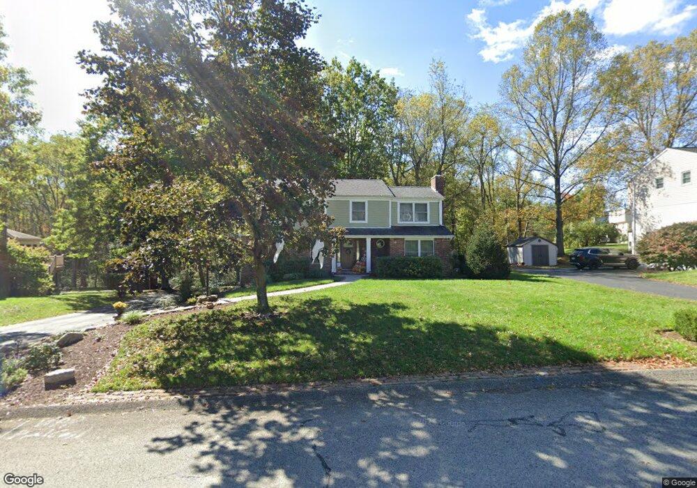
5903 Graybrook Dr Export, PA 15632
Estimated Value: $188,976 - $498,000
4
Beds
3
Baths
--
Sq Ft
18,818
Sq Ft
About This Home
This home is located at 5903 Graybrook Dr, Export, PA 15632 and is currently estimated at $401,744. 5903 Graybrook Dr is a home located in Westmoreland County with nearby schools including Franklin Regional Senior High School and Mother of Sorrows School.
Ownership History
Date
Name
Owned For
Owner Type
Purchase Details
Closed on
Jul 25, 2009
Sold by
Reedy Richard Dale
Bought by
Liston Beth A and Liston Richard A
Current Estimated Value
Home Financials for this Owner
Home Financials are based on the most recent Mortgage that was taken out on this home.
Original Mortgage
$196,700
Interest Rate
5.12%
Mortgage Type
New Conventional
Purchase Details
Closed on
Dec 21, 2007
Sold by
Sabol Lawrence A and Sabol Lisa A
Bought by
Reedy Richard Dale
Home Financials for this Owner
Home Financials are based on the most recent Mortgage that was taken out on this home.
Original Mortgage
$253,170
Interest Rate
6.27%
Mortgage Type
Purchase Money Mortgage
Create a Home Valuation Report for This Property
The Home Valuation Report is an in-depth analysis detailing your home's value as well as a comparison with similar homes in the area
Home Values in the Area
Average Home Value in this Area
Purchase History
| Date | Buyer | Sale Price | Title Company |
|---|---|---|---|
| Liston Beth A | $245,900 | None Available | |
| Reedy Richard Dale | $261,000 | None Available |
Source: Public Records
Mortgage History
| Date | Status | Borrower | Loan Amount |
|---|---|---|---|
| Previous Owner | Liston Beth A | $196,700 | |
| Previous Owner | Reedy Richard Dale | $253,170 |
Source: Public Records
Tax History
| Year | Tax Paid | Tax Assessment Tax Assessment Total Assessment is a certain percentage of the fair market value that is determined by local assessors to be the total taxable value of land and additions on the property. | Land | Improvement |
|---|---|---|---|---|
| 2025 | $6,330 | $41,540 | $6,430 | $35,110 |
| 2024 | $6,185 | $41,540 | $6,430 | $35,110 |
| 2023 | $5,811 | $41,540 | $6,430 | $35,110 |
| 2022 | $5,697 | $41,540 | $6,430 | $35,110 |
| 2021 | $5,572 | $41,540 | $6,430 | $35,110 |
| 2020 | $5,467 | $41,540 | $6,430 | $35,110 |
| 2019 | $5,355 | $41,540 | $6,430 | $35,110 |
| 2018 | $5,261 | $41,540 | $6,430 | $35,110 |
| 2017 | $5,152 | $41,540 | $6,430 | $35,110 |
| 2016 | $5,049 | $41,540 | $6,430 | $35,110 |
| 2015 | $5,049 | $41,540 | $6,430 | $35,110 |
| 2014 | $5,015 | $41,540 | $6,430 | $35,110 |
Source: Public Records
Map
Nearby Homes
- 5934 Graybrook Dr
- 5812 Torrance Dr
- 37 Hones Rd
- 1044 Hillstone Village Dr
- 1316 S Valley Dr
- 1213 Harrison Ct
- 309 Jefferson St
- 1022 Lexington Dr
- 2667 Puckety Dr
- 5816 Madison Ave
- 1001 Black Sands Dr
- 1002 Black Sands Dr
- 5801 Lincoln Ave
- 5816 Tyler Ave
- 6004 Augusta Ln
- 2001 Blackthorne Dr
- 0 William Penn Hwy Unit 1740233
- 2903 Italy Rd
- 1049 Black Sands Dr
- 5648 Monroe Cir
- 5905 Graybrook Dr
- 5901 Graybrook Dr
- 2209 Woodmont Dr
- 5906 Graybrook Dr
- 2207 Woodmont Dr
- 5904 Graybrook Dr
- 5902 Graybrook Dr
- 2205 Woodmont Dr
- 5911 Graybrook Dr
- 2203 Woodmont Dr
- 2210 Woodmont Dr
- 2208 Woodmont Dr
- 2212 Woodmont Dr
- 2206 Woodmont Dr
- 2215 Woodmont Dr
- 5912 Graybrook Dr
- 2214 Woodmont Dr
- 5913 Graybrook Dr
- 5864 Claridge Rd
- 3 Pheasant Ln
Your Personal Tour Guide
Ask me questions while you tour the home.