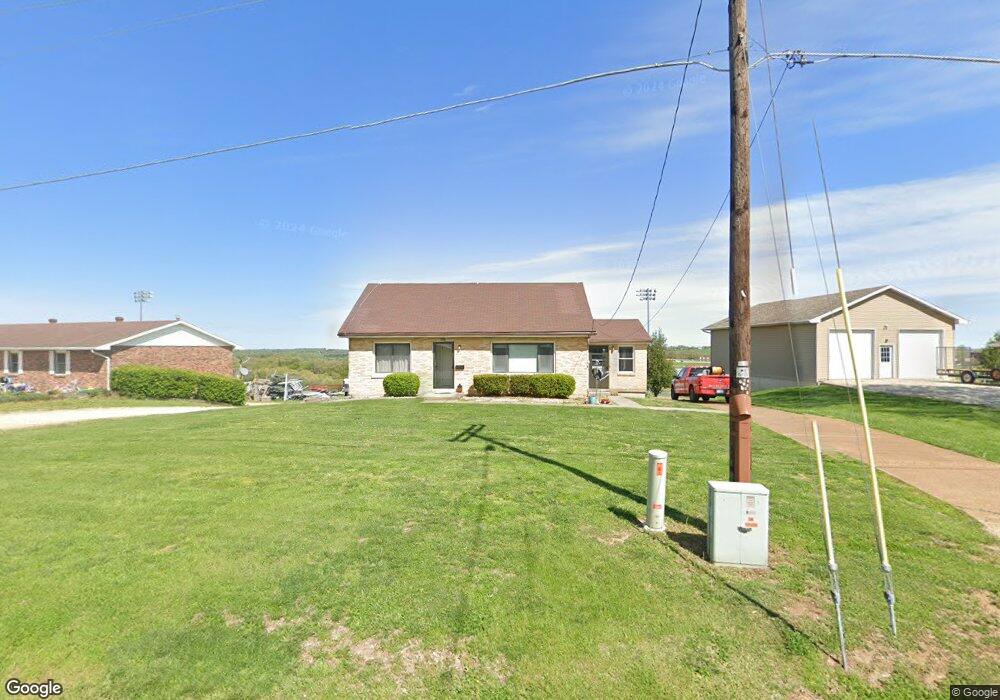
5907 Route B Jefferson City, MO 65101
Estimated Value: $221,092 - $283,000
2
Beds
1
Bath
1,372
Sq Ft
$185/Sq Ft
Est. Value
About This Home
This home is located at 5907 Route B, Jefferson City, MO 65101 and is currently estimated at $253,273, approximately $184 per square foot. 5907 Route B is a home located in Cole County with nearby schools including Blair Oaks Elementary School, Blair Oaks Middle School, and Blair Oaks High School.
Ownership History
Date
Name
Owned For
Owner Type
Purchase Details
Closed on
Aug 26, 2025
Sold by
Shipman James B and Shipman Kacey E
Bought by
Struemph Mark J
Current Estimated Value
Home Financials for this Owner
Home Financials are based on the most recent Mortgage that was taken out on this home.
Original Mortgage
$50,000
Outstanding Balance
$50,000
Interest Rate
5.87%
Mortgage Type
New Conventional
Estimated Equity
$203,273
Purchase Details
Closed on
Jun 19, 2020
Sold by
Struemph Clara M
Bought by
Shipman James B and Shipman Kacey E
Create a Home Valuation Report for This Property
The Home Valuation Report is an in-depth analysis detailing your home's value as well as a comparison with similar homes in the area
Purchase History
| Date | Buyer | Sale Price | Title Company |
|---|---|---|---|
| Struemph Mark J | -- | Midwest Title | |
| Shipman James B | -- | None Available |
Source: Public Records
Mortgage History
| Date | Status | Borrower | Loan Amount |
|---|---|---|---|
| Open | Struemph Mark J | $50,000 |
Source: Public Records
Tax History
| Year | Tax Paid | Tax Assessment Tax Assessment Total Assessment is a certain percentage of the fair market value that is determined by local assessors to be the total taxable value of land and additions on the property. | Land | Improvement |
|---|---|---|---|---|
| 2025 | $1,027 | $20,670 | $3,040 | $17,630 |
| 2024 | $10 | $18,640 | $0 | $18,640 |
| 2023 | $971 | $18,640 | $0 | $18,640 |
| 2022 | $974 | $18,640 | $0 | $18,640 |
| 2021 | $973 | $18,640 | $0 | $18,640 |
| 2020 | $974 | $24,624 | $3,040 | $21,584 |
| 2019 | $975 | $22,154 | $3,040 | $19,114 |
| 2018 | $918 | $20,748 | $3,040 | $17,708 |
| 2017 | $864 | $18,639 | $3,040 | $15,599 |
| 2016 | -- | $18,639 | $3,040 | $15,599 |
| 2015 | $869 | $0 | $0 | $0 |
| 2014 | $869 | $18,639 | $3,040 | $15,599 |
Source: Public Records
Map
Nearby Homes
- 1217 Ashbury Way
- 922 Hickory Ct
- 905 Hickory Ct
- 5605 Dogwood Trail
- 1512 Grandvalley Dr
- 5109 Wardsville Rd
- 5710 Tanner Bridge Rd
- 121 Highland Waye
- 5413 Aberdeen Waye
- 5216 Edinburgh Waye
- 1211 Tara Rd
- 2328 Green Meadow Dr
- 3814 Pear Tree Ct
- 517 Whispering Cedars Ln
- 510 Whispering Cedars Ln
- 504 Whispering Cedars Ln
- 601 Whispering Cedars Ln
- 605 Whispering Cedars Ln
- 609 Whispering Cedars Ln
- 613 Whispering Cedars Ln
- 5915 Route B
- 5906 Route B
- 6001 Route B
- 5814 Route B
- 5902 Route B
- 5910 Route B
- 5916 Route B
- 5805 Wardsville Rd
- 6006 Route B
- 5727 Wardsville Rd
- 6100 Route B
- 1516 Friendship Rd
- 5817 Cobblestone Ct
- 6014 Route B
- 5825 Cobblestone Ct
- 5719 Wardsville Rd
- 5905 Cobblestone Ct
- 5812 Cobblestone Ct
- 6113 Route B
- 5816 Cobblestone Ct
Your Personal Tour Guide
Ask me questions while you tour the home.