Estimated Value: $264,570 - $304,000
3
Beds
2
Baths
1,120
Sq Ft
$252/Sq Ft
Est. Value
About This Home
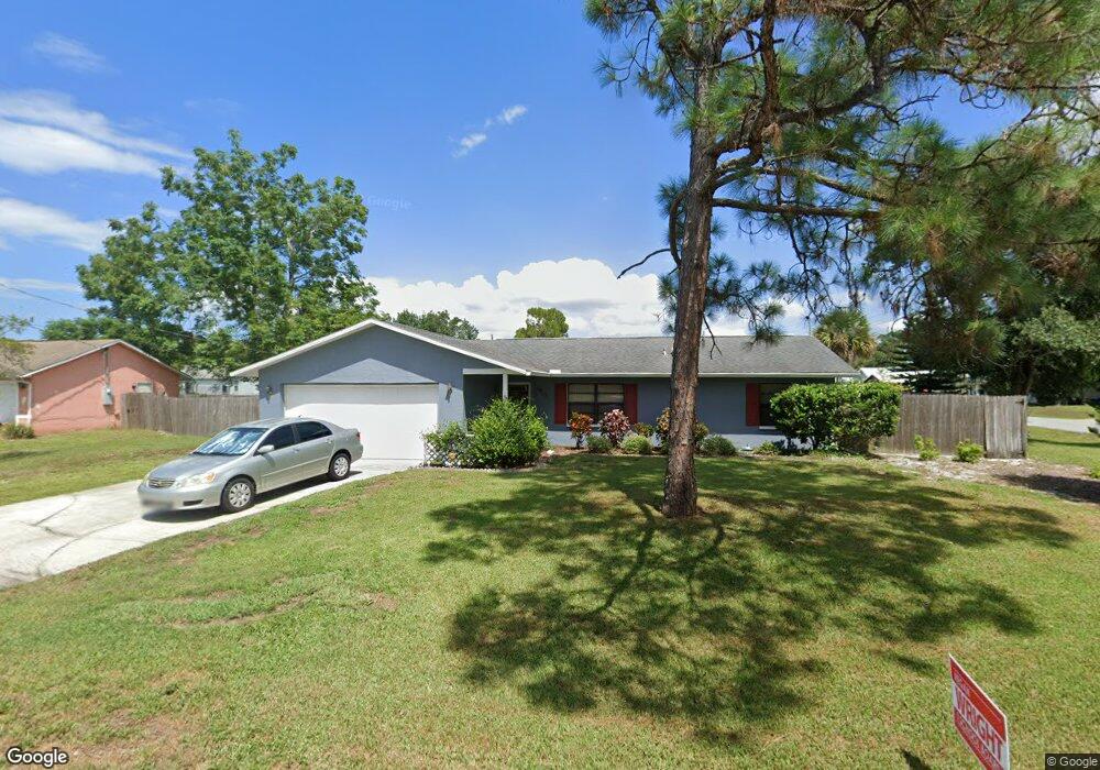
This home is located at 5913 Ackard Ave, Cocoa, FL 32927 and is currently estimated at $281,893, approximately $251 per square foot. 5913 Ackard Ave is a home located in Brevard County with nearby schools including Challenger 7 Elementary School, Space Coast Junior/Senior High School, and Sculptor Charter School.
Ownership History
Date
Name
Owned For
Owner Type
Purchase Details
Closed on
May 11, 2004
Sold by
Corr Roddy M and Corr Colleen B
Bought by
Creecy Darrell and Laventure Dana
Current Estimated Value
Home Financials for this Owner
Home Financials are based on the most recent Mortgage that was taken out on this home.
Original Mortgage
$96,800
Outstanding Balance
$46,912
Interest Rate
5.98%
Estimated Equity
$234,981
Purchase Details
Closed on
Sep 18, 2003
Sold by
Kennedy Robert L and Kennedy Patricia M
Bought by
Corr Roddy M and Corr Colleen B
Create a Home Valuation Report for This Property
The Home Valuation Report is an in-depth analysis detailing your home's value as well as a comparison with similar homes in the area
Home Values in the Area
Average Home Value in this Area
Purchase History
| Date | Buyer | Sale Price | Title Company |
|---|---|---|---|
| Creecy Darrell | $121,000 | Glow Title & Escrow | |
| Corr Roddy M | $91,000 | Gulfatlantic Title |
Source: Public Records
Mortgage History
| Date | Status | Borrower | Loan Amount |
|---|---|---|---|
| Open | Creecy Darrell | $96,800 |
Source: Public Records
Tax History
| Year | Tax Paid | Tax Assessment Tax Assessment Total Assessment is a certain percentage of the fair market value that is determined by local assessors to be the total taxable value of land and additions on the property. | Land | Improvement |
|---|---|---|---|---|
| 2025 | $1,034 | $76,350 | -- | -- |
| 2024 | $1,014 | $74,200 | -- | -- |
| 2023 | $1,014 | $72,040 | $0 | $0 |
| 2022 | $957 | $69,950 | $0 | $0 |
| 2021 | $959 | $67,920 | $0 | $0 |
| 2020 | $914 | $66,990 | $0 | $0 |
| 2019 | $861 | $65,490 | $0 | $0 |
| 2018 | $862 | $64,270 | $0 | $0 |
| 2017 | $863 | $62,950 | $0 | $0 |
| 2016 | $871 | $61,660 | $18,000 | $43,660 |
| 2015 | $877 | $61,240 | $15,000 | $46,240 |
| 2014 | $882 | $60,760 | $11,000 | $49,760 |
Source: Public Records
Map
Nearby Homes
- 5950 Ackard Ave
- 6020 Cannon Ave
- 6094 Cardiff Ave
- 5221 Carrick Rd
- 5914 Stillwater Ave
- 5945 Coker Ave
- 5215 Holden Rd
- 4905 Bridge Rd
- 5946 Deer Ln
- 5220 Holden Rd
- 4975 Fay Blvd
- 6210 Stillwater Ave
- 5265 Fay Blvd
- 6375 Cable Ave
- 6310 Depot Ave
- 4545 Rosebud St
- 6450 Ember Ave
- 6438 Hudson Rd
- 00 Unknown
- 0000 Grissom Pkwy
- 5923 Ackard Ave
- 0 Bridge Rd
- 5912 Banbury Ave
- 5134 Bridge Rd
- 5922 Banbury Ave
- 5109 Bridge Rd
- 5920 Ackard Ave
- 5933 Ackard Ave
- 5121 Bridge Rd
- 5097 Bridge Rd
- 5146 Bridge Rd
- 5932 Banbury Ave
- 5085 Bridge Rd
- 5943 Ackard Ave
- 5145 Bridge Rd
- 5925 Cannon Ave
- 5060 Bridge Rd
- 5915 Cannon Ave
- 5942 Banbury Ave
- 5940 Ackard Ave
Your Personal Tour Guide
Ask me questions while you tour the home.