Estimated Value: $232,647 - $491,000
3
Beds
1
Bath
1,768
Sq Ft
$200/Sq Ft
Est. Value
About This Home
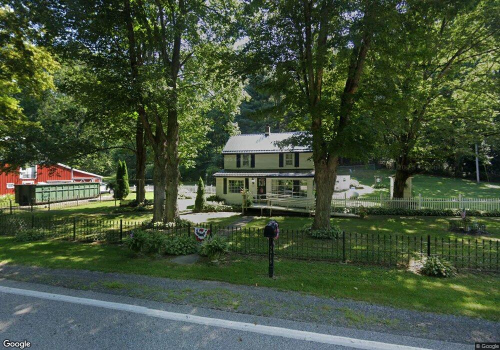
This home is located at 5918 State Route 312, Logan, OH 43138 and is currently estimated at $353,912, approximately $200 per square foot. 5918 State Route 312 is a home located in Perry County with nearby schools including Green Elementary School.
Ownership History
Date
Name
Owned For
Owner Type
Purchase Details
Closed on
Feb 3, 2020
Sold by
Donofrio James A and Donofrio Barbara J
Bought by
Donofrio Jason A and Donofrio Tammy R
Current Estimated Value
Home Financials for this Owner
Home Financials are based on the most recent Mortgage that was taken out on this home.
Original Mortgage
$206,000
Outstanding Balance
$182,813
Interest Rate
3.72%
Mortgage Type
VA
Estimated Equity
$171,099
Create a Home Valuation Report for This Property
The Home Valuation Report is an in-depth analysis detailing your home's value as well as a comparison with similar homes in the area
Home Values in the Area
Average Home Value in this Area
Purchase History
| Date | Buyer | Sale Price | Title Company |
|---|---|---|---|
| Donofrio Jason A | $206,000 | Elite Land Title |
Source: Public Records
Mortgage History
| Date | Status | Borrower | Loan Amount |
|---|---|---|---|
| Open | Donofrio Jason A | $206,000 |
Source: Public Records
Tax History Compared to Growth
Tax History
| Year | Tax Paid | Tax Assessment Tax Assessment Total Assessment is a certain percentage of the fair market value that is determined by local assessors to be the total taxable value of land and additions on the property. | Land | Improvement |
|---|---|---|---|---|
| 2024 | $921 | $34,690 | $11,550 | $23,140 |
| 2023 | $921 | $34,690 | $11,550 | $23,140 |
| 2022 | $723 | $27,050 | $6,380 | $20,670 |
| 2021 | $725 | $27,050 | $6,380 | $20,670 |
| 2020 | $725 | $27,050 | $6,380 | $20,670 |
| 2019 | $712 | $26,830 | $8,500 | $18,330 |
| 2018 | $700 | $33,720 | $15,390 | $18,330 |
| 2017 | $837 | $33,720 | $15,390 | $18,330 |
| 2016 | $978 | $33,550 | $11,950 | $21,600 |
| 2015 | $996 | $33,550 | $11,950 | $21,600 |
| 2014 | $1,266 | $33,550 | $11,950 | $21,600 |
| 2013 | $812 | $32,430 | $10,830 | $21,600 |
| 2012 | -- | $30,040 | $8,440 | $21,600 |
Source: Public Records
Map
Nearby Homes
- 5840 Township Road 248
- 5400 Saunders Rd
- 4181 Van Horn Rd SW
- 0 Ohio 668
- 0 Schmeltzer Rd
- 0 Bethel Rd SE Unit 225039271
- 2910 Township Road 185 SW
- 9168 Bremen Rd
- 5618 Ohio 664
- 3675 County Rd 11
- 3385 Marietta Rd SW
- 8931 Sacred Heart Rd SE
- 4658 State Route 668 S
- 35041 Hunter Rd
- 10132 Bremen Rd
- 314 Chinook Ln
- 8941 State Route 664 N
- 12151 State Route 93 N
- 8215 Pleasantview Rd SE
- 9600 Larimer Rd
- 5881 Ohio 312
- 6130 State Route 312
- 6161 State Route 312
- 5708 State Route 312
- 5706 State Route 312
- 6215 State Route 312
- 5487 Township Road 430
- 5510 State Route 312
- 5730 Township Road 430
- 6330 State Route 312
- 5485 Township Road 430
- 5845 Township Road 430
- 5845 Township Road 430
- 5832 Township Road 430
- 5758 Township Road 430
- 0 Twp Rd 248 Unit 9920513
- 0 Twp Rd 248 Unit 217001349
- 5875 Township Road 430
- 5870 Township Road 430
- 5756 Township Road 430