Estimated Value: $988,000 - $2,135,000
3
Beds
3
Baths
3,804
Sq Ft
$366/Sq Ft
Est. Value
About This Home
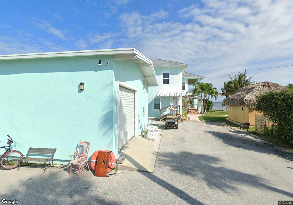
This home is located at 5925 S Us Highway 1, Grant, FL 32949 and is currently estimated at $1,393,828, approximately $366 per square foot. 5925 S Us Highway 1 is a home located in Brevard County with nearby schools including Sunrise Elementary School, Stone Magnet Middle School, and Bayside High School.
Ownership History
Date
Name
Owned For
Owner Type
Purchase Details
Closed on
Dec 4, 2008
Sold by
Quatraro Dorothy N and Quatraro Michael J
Bought by
Quatraro Michael J
Current Estimated Value
Purchase Details
Closed on
Feb 16, 1996
Sold by
Geil John J
Bought by
Quatraro Michael J and Quatraro Dorothy N
Home Financials for this Owner
Home Financials are based on the most recent Mortgage that was taken out on this home.
Original Mortgage
$120,000
Outstanding Balance
$3,934
Interest Rate
7.03%
Mortgage Type
Purchase Money Mortgage
Estimated Equity
$1,389,894
Create a Home Valuation Report for This Property
The Home Valuation Report is an in-depth analysis detailing your home's value as well as a comparison with similar homes in the area
Home Values in the Area
Average Home Value in this Area
Purchase History
| Date | Buyer | Sale Price | Title Company |
|---|---|---|---|
| Quatraro Michael J | -- | Paradise Title | |
| Quatraro Michael J | $135,000 | -- | |
| Quatraro Michael J | -- | -- |
Source: Public Records
Mortgage History
| Date | Status | Borrower | Loan Amount |
|---|---|---|---|
| Open | Quatraro Michael J | $120,000 | |
| Closed | Quatraro Michael J | $120,000 |
Source: Public Records
Tax History Compared to Growth
Tax History
| Year | Tax Paid | Tax Assessment Tax Assessment Total Assessment is a certain percentage of the fair market value that is determined by local assessors to be the total taxable value of land and additions on the property. | Land | Improvement |
|---|---|---|---|---|
| 2025 | $11,409 | $826,500 | -- | -- |
| 2024 | $11,228 | $787,260 | -- | -- |
| 2023 | $11,228 | $765,570 | $0 | $0 |
| 2022 | $9,478 | $663,800 | $0 | $0 |
| 2021 | $9,659 | $627,010 | $0 | $0 |
| 2020 | $9,580 | $634,620 | $0 | $0 |
| 2019 | $9,587 | $612,760 | $0 | $0 |
| 2018 | $9,554 | $597,230 | $0 | $0 |
| 2017 | $9,660 | $585,930 | $0 | $0 |
| 2016 | $9,869 | $575,800 | $320,130 | $255,670 |
| 2015 | $10,046 | $571,910 | $277,630 | $294,280 |
| 2014 | $9,514 | $533,410 | $277,630 | $255,780 |
Source: Public Records
Map
Nearby Homes
- 25 Vip Island
- 25 Vip Island Unit A
- 36 Vip Island Unit A
- 35 Vip Island B
- 50 Vip Island
- 42 Vip Island
- 4660 Mount Pleasant Ave
- 48 Vip Island Unit A
- 8 Vip Island Unit B
- 51 Vip Island Unit B
- 4495 Sand Point Rd
- 6570 Whispering Pines Ln
- 4540 Hunters Run Cir
- 5900 Brabrook Ave
- 6110 Brabrook Ave
- 000e Berry St
- 000d Berry St
- 000c Berry St
- 000b Berry St
- 000a Berry St
- 5905 U S 1
- 5905 S Us Highway 1
- 5935 S Us Highway 1
- 5955 S Us Highway 1
- 5965 U S 1
- 5965 S Us Highway 1
- 000 Mount Pleasant Ave
- 5975 S Us Highway 1
- 6005 U S 1
- 4940 Cooke Ave
- 6010 Us Highway 1
- 6015 S Us Highway 1
- 6015 U S 1
- 6010 U S 1
- 0000 Cooke Ave
- 6025 S Us Highway 1
- 4935 Cooke Ave
- 000 Us Highway 1 Lot 769
- 000 Us Highway 1 Lot 22
- 000 S Us Hwy 1