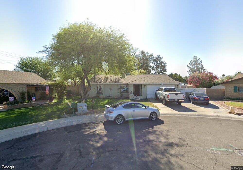
5927 W Pershing Ave Glendale, AZ 85304
Estimated Value: $395,618 - $506,000
Studio
2
Baths
1,920
Sq Ft
$239/Sq Ft
Est. Value
About This Home
This home is located at 5927 W Pershing Ave, Glendale, AZ 85304 and is currently estimated at $459,155, approximately $239 per square foot. 5927 W Pershing Ave is a home located in Maricopa County with nearby schools including Desert Valley Elementary School, Ironwood High School, and Legacy Traditional School - Glendale.
Ownership History
Date
Name
Owned For
Owner Type
Purchase Details
Closed on
Mar 20, 1998
Sold by
Larrabee Bruce E
Bought by
Larson David R and Larson Julie A
Current Estimated Value
Home Financials for this Owner
Home Financials are based on the most recent Mortgage that was taken out on this home.
Original Mortgage
$92,000
Outstanding Balance
$16,830
Interest Rate
7.02%
Mortgage Type
New Conventional
Estimated Equity
$442,325
Create a Home Valuation Report for This Property
The Home Valuation Report is an in-depth analysis detailing your home's value as well as a comparison with similar homes in the area
Home Values in the Area
Average Home Value in this Area
Purchase History
| Date | Buyer | Sale Price | Title Company |
|---|---|---|---|
| Larson David R | $115,000 | Capital Title Agency |
Source: Public Records
Mortgage History
| Date | Status | Borrower | Loan Amount |
|---|---|---|---|
| Open | Larson David R | $92,000 |
Source: Public Records
Tax History
| Year | Tax Paid | Tax Assessment Tax Assessment Total Assessment is a certain percentage of the fair market value that is determined by local assessors to be the total taxable value of land and additions on the property. | Land | Improvement |
|---|---|---|---|---|
| 2025 | $1,732 | $22,210 | -- | -- |
| 2024 | $1,728 | $21,152 | -- | -- |
| 2023 | $1,728 | $34,860 | $6,970 | $27,890 |
| 2022 | $1,712 | $27,110 | $5,420 | $21,690 |
| 2021 | $1,837 | $24,880 | $4,970 | $19,910 |
| 2020 | $1,865 | $24,420 | $4,880 | $19,540 |
| 2019 | $1,813 | $23,130 | $4,620 | $18,510 |
| 2018 | $1,771 | $21,330 | $4,260 | $17,070 |
| 2017 | $1,392 | $15,600 | $3,120 | $12,480 |
| 2016 | $1,383 | $15,160 | $3,030 | $12,130 |
| 2015 | $1,297 | $14,810 | $2,960 | $11,850 |
Source: Public Records
Map
Nearby Homes
- 5757 W Eugie Ave Unit 1102
- 5757 W Eugie Ave Unit 1110
- 5757 W Eugie Ave Unit 2049
- 5757 W Eugie Ave Unit 2114
- 5757 W Eugie Ave Unit 2062
- 6107 W Windrose Dr
- 5702 W Windrose Dr
- 6316 W Sweetwater Ave
- 13203 N 56th Ave
- 5622 W Aster Dr
- 13201 N 64th Dr
- 12223 N 60th Ln
- 6428 W Eugie Ave
- 13217 N 65th Dr
- 14408 N 57th Dr
- 5529 W Aster Dr
- 6504 W Corrine Dr
- 14461 N 58th Ave
- 5541 W Crocus Dr
- 14474 N 57th Ave
- 13216 N 59th Dr
- 5928 W Pershing Ave
- 5935 W Pershing Ave
- 13210 N 59th Dr
- 5934 W Pershing Ave
- 13219 N 60th Ave
- 13215 N 59th Dr
- 5940 W Pershing Ave
- 13213 N 60th Ave
- 13204 N 59th Dr
- 13239 N 60th Ave
- 5930 W Surrey Ave
- 13209 N 59th Dr
- 5938 W Surrey Ave
- 13203 N 59th Dr
- 13245 N 60th Ave
- 13226 N 60th Ave
- 13220 N 60th Ave
- 13232 N 60th Ave
- 13214 N 60th Ave
Your Personal Tour Guide
Ask me questions while you tour the home.