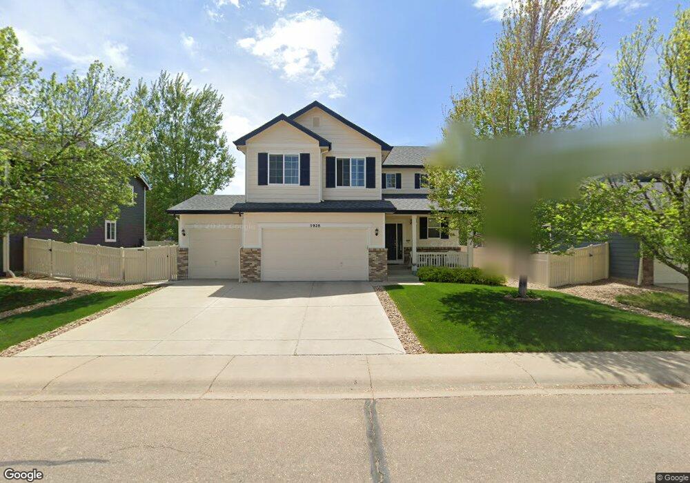
5928 Oak Meadows Blvd Firestone, CO 80504
Estimated Value: $494,000 - $560,000
4
Beds
3
Baths
1,764
Sq Ft
$299/Sq Ft
Est. Value
About This Home
This home is located at 5928 Oak Meadows Blvd, Firestone, CO 80504 and is currently estimated at $528,257, approximately $299 per square foot. 5928 Oak Meadows Blvd is a home located in Weld County with nearby schools including Centennial Elementary School, Coal Ridge Middle School, and Mead High School.
Ownership History
Date
Name
Owned For
Owner Type
Purchase Details
Closed on
Jul 28, 2010
Sold by
Richmond American Homes Of Colorado Inc
Bought by
Bond Christopher and Bond Elizabeth A
Current Estimated Value
Home Financials for this Owner
Home Financials are based on the most recent Mortgage that was taken out on this home.
Original Mortgage
$210,610
Outstanding Balance
$139,233
Interest Rate
4.54%
Mortgage Type
New Conventional
Estimated Equity
$389,024
Create a Home Valuation Report for This Property
The Home Valuation Report is an in-depth analysis detailing your home's value as well as a comparison with similar homes in the area
Home Values in the Area
Average Home Value in this Area
Purchase History
| Date | Buyer | Sale Price | Title Company |
|---|---|---|---|
| Bond Christopher | $235,600 | American Home Title & Escrow |
Source: Public Records
Mortgage History
| Date | Status | Borrower | Loan Amount |
|---|---|---|---|
| Open | Bond Christopher | $210,610 |
Source: Public Records
Tax History
| Year | Tax Paid | Tax Assessment Tax Assessment Total Assessment is a certain percentage of the fair market value that is determined by local assessors to be the total taxable value of land and additions on the property. | Land | Improvement |
|---|---|---|---|---|
| 2025 | $3,169 | $31,870 | $7,380 | $24,490 |
| 2024 | $3,169 | $31,870 | $7,380 | $24,490 |
| 2023 | $3,040 | $34,370 | $7,980 | $26,390 |
| 2022 | $2,789 | $26,660 | $5,630 | $21,030 |
| 2021 | $2,815 | $27,420 | $5,790 | $21,630 |
| 2020 | $2,639 | $25,910 | $4,290 | $21,620 |
| 2019 | $2,678 | $25,910 | $4,290 | $21,620 |
| 2018 | $2,343 | $23,530 | $4,320 | $19,210 |
| 2017 | $2,395 | $23,530 | $4,320 | $19,210 |
| 2016 | $2,192 | $21,190 | $4,460 | $16,730 |
| 2015 | $2,125 | $21,190 | $4,460 | $16,730 |
| 2014 | $1,768 | $17,650 | $3,260 | $14,390 |
Source: Public Records
Map
Nearby Homes
- 5950 Twilight Ave
- 6188 Twilight Ave
- 10818 Cimarron St Unit 1006
- 6348 Union Ave
- 5965 Thistle Ridge Ave
- 6911 Utica Ave
- 11392 Ebony St
- 10516 Sunburst Ave
- 6744 Utica Ave
- 6749 Utica Ave
- 6757 Utica Ave
- 6765 Utica Cir
- 10548 Sunburst Ave
- 6773 Utica Cir
- 6781 Utica Cir
- 6785 Utica Cir
- 10510 Dresden St
- 6793 Utica Cir
- 6801 Utica Cir
- 6200 Sparrow Ave
- 5942 Oak Meadows Blvd
- 5914 Oak Meadows Blvd
- 11215 Columbine St
- 11214 Coal Ridge St
- 5927 Oak Meadows Blvd
- 5913 Oak Meadows Blvd
- 11205 Columbine St
- 11198 Coal Ridge St
- 5888 Oak Meadows Blvd
- 11232 Columbine St
- 11220 Columbine St
- 11217 Coal Ridge St
- 11191 Columbine St
- 11186 Coal Ridge St
- 11276 Coal Ridge St
- 5887 Oak Meadows Blvd
- 11208 Columbine St
- 11260 Columbine St
- 5874 Oak Meadows Blvd
- 11196 Columbine St
Your Personal Tour Guide
Ask me questions while you tour the home.