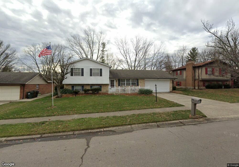
593 Preston Dr Waynesville, OH 45068
Wayne Township NeighborhoodEstimated Value: $275,429 - $302,000
3
Beds
3
Baths
1,088
Sq Ft
$262/Sq Ft
Est. Value
About This Home
This home is located at 593 Preston Dr, Waynesville, OH 45068 and is currently estimated at $284,607, approximately $261 per square foot. 593 Preston Dr is a home located in Warren County with nearby schools including Waynesville Elementary School, Waynesville Middle School, and Waynesville High School.
Ownership History
Date
Name
Owned For
Owner Type
Purchase Details
Closed on
Apr 9, 1991
Sold by
Henderson Doris A and Henderson Doris A
Bought by
Henderson and Henderson Brent L
Current Estimated Value
Purchase Details
Closed on
May 11, 1989
Sold by
Henderson Alfred L and Henderson Do
Bought by
Henderson and Henderson Doris A
Purchase Details
Closed on
Sep 16, 1981
Sold by
Balata Balata and Balata Barbara M
Purchase Details
Closed on
Feb 2, 1979
Sold by
Bel Oak Realty Co
Purchase Details
Closed on
Aug 23, 1978
Sold by
Gem City Lumber Co
Purchase Details
Closed on
May 12, 1978
Sold by
Gem City Lumber Company
Create a Home Valuation Report for This Property
The Home Valuation Report is an in-depth analysis detailing your home's value as well as a comparison with similar homes in the area
Home Values in the Area
Average Home Value in this Area
Purchase History
| Date | Buyer | Sale Price | Title Company |
|---|---|---|---|
| Henderson | $75,000 | -- | |
| Henderson | -- | -- | |
| -- | $60,500 | -- | |
| -- | $55,800 | -- | |
| -- | $11,000 | -- | |
| -- | -- | -- |
Source: Public Records
Tax History Compared to Growth
Tax History
| Year | Tax Paid | Tax Assessment Tax Assessment Total Assessment is a certain percentage of the fair market value that is determined by local assessors to be the total taxable value of land and additions on the property. | Land | Improvement |
|---|---|---|---|---|
| 2024 | $3,263 | $74,630 | $21,000 | $53,630 |
| 2023 | $2,826 | $56,084 | $12,915 | $43,169 |
| 2022 | $2,771 | $56,084 | $12,915 | $43,169 |
| 2021 | $2,669 | $56,084 | $12,915 | $43,169 |
| 2020 | $2,527 | $45,598 | $10,500 | $35,098 |
| 2019 | $2,528 | $45,598 | $10,500 | $35,098 |
| 2018 | $2,529 | $45,598 | $10,500 | $35,098 |
| 2017 | $2,713 | $45,651 | $10,675 | $34,976 |
| 2016 | $2,551 | $45,651 | $10,675 | $34,976 |
| 2015 | $2,555 | $45,651 | $10,675 | $34,976 |
| 2014 | $2,527 | $42,660 | $9,980 | $32,690 |
| 2013 | $2,522 | $44,910 | $10,500 | $34,410 |
Source: Public Records
Map
Nearby Homes
- 363 Victoria Place
- 1106 Lytle Rd
- 1198 Lytle Rd
- 437 N Main St
- 60 E Ellis Dr
- 1036 Bayberry Dr
- 7219 N Route 42
- 53 S 4th St
- 7219 U S 42
- 460 Miami St
- 1106 Brookfield Dr Unit 1106
- 7219 N Us Rt 42
- 1 Cumberland Ct
- 155 S Main St
- 196 S 3rd St
- 0 Ohio 73 Unit 944080
- 127 New Burlington Rd
- 401 Wilkerson Ln
- 4 Corwin Rd
- 8519 Old Stage Rd