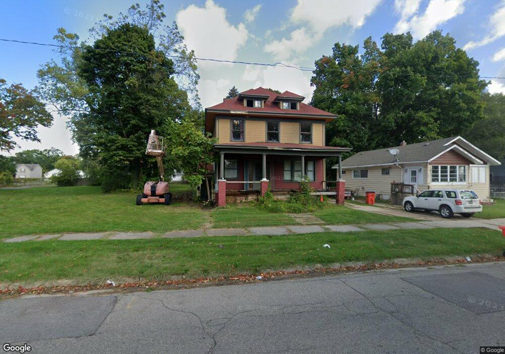
593 Territorial Rd Benton Harbor, MI 49022
Estimated Value: $136,000 - $413,000
7
Beds
3
Baths
2,780
Sq Ft
$87/Sq Ft
Est. Value
About This Home
This home is located at 593 Territorial Rd, Benton Harbor, MI 49022 and is currently estimated at $242,424, approximately $87 per square foot. 593 Territorial Rd is a home located in Berrien County with nearby schools including Fair Plain Middle School, Benton Harbor High School, and Mildred C. Wells Preparatory Academy.
Ownership History
Date
Name
Owned For
Owner Type
Purchase Details
Closed on
Jul 31, 2003
Sold by
Johnson Andrew W and Johnson Joan G
Bought by
Fairbanks Capital Corp and Tcif Reo 2 Llc
Current Estimated Value
Purchase Details
Closed on
Jun 10, 1999
Purchase Details
Closed on
Dec 26, 1996
Purchase Details
Closed on
Oct 16, 1996
Purchase Details
Closed on
May 24, 1996
Purchase Details
Closed on
Jul 1, 1994
Purchase Details
Closed on
Apr 13, 1987
Create a Home Valuation Report for This Property
The Home Valuation Report is an in-depth analysis detailing your home's value as well as a comparison with similar homes in the area
Home Values in the Area
Average Home Value in this Area
Purchase History
| Date | Buyer | Sale Price | Title Company |
|---|---|---|---|
| Fairbanks Capital Corp | $35,762 | -- | |
| -- | $45,900 | -- | |
| -- | -- | -- | |
| -- | $100 | -- | |
| -- | $1,300 | -- | |
| -- | $100 | -- | |
| -- | $100 | -- |
Source: Public Records
Tax History
| Year | Tax Paid | Tax Assessment Tax Assessment Total Assessment is a certain percentage of the fair market value that is determined by local assessors to be the total taxable value of land and additions on the property. | Land | Improvement |
|---|---|---|---|---|
| 2025 | $1,062 | $48,700 | $0 | $0 |
| 2024 | $1,005 | $47,500 | $0 | $0 |
| 2023 | $738 | $33,700 | $0 | $0 |
| 2022 | $913 | $28,400 | $0 | $0 |
| 2021 | $934 | $28,800 | $900 | $27,900 |
| 2020 | $922 | $28,500 | $0 | $0 |
| 2019 | $906 | $21,000 | $0 | $0 |
| 2018 | $899 | $19,800 | $0 | $0 |
| 2017 | $1,140 | $25,900 | $0 | $0 |
| 2016 | $1,118 | $26,200 | $0 | $0 |
| 2015 | $1,115 | $25,200 | $0 | $0 |
| 2014 | $1,156 | $30,500 | $0 | $0 |
Source: Public Records
Map
Nearby Homes
- 575 Cass St
- 490 Territorial Rd
- 770 Territorial Rd
- 696 Highland Ave
- 470 N Mccord St
- 710 Buss Ave
- 363 Brunson Ave
- 309 High St
- 137 Cornelia St
- 255 High St
- 992 Highland Ave
- 378 Pipestone St
- 561 Heck Ct
- 394 Linden St
- VL Eighth Ninth Boughton St
- 520 Broadway
- 596 Superior St
- 210 Market Place
- 468 Colfax Ave
- 614 Pavone St
- 635 Territorial Rd
- 651 Territorial Rd
- 601 Territorial Rd
- 579 Territorial Rd
- 607 Territorial Rd
- 615 Territorial Rd
- 608 Green Ave
- 578 Green Ave
- 586 Territorial Rd
- 600 Territorial Rd
- 614 Green Ave
- 580 Territorial Rd
- 621 Territorial Rd
- 572 Territorial Rd
- 620 Green Ave
- 612 Territorial Rd
- 566 Territorial Rd
- 620 Territorial Rd
- 593 Green Ave
- 577 Green Ave
Your Personal Tour Guide
Ask me questions while you tour the home.