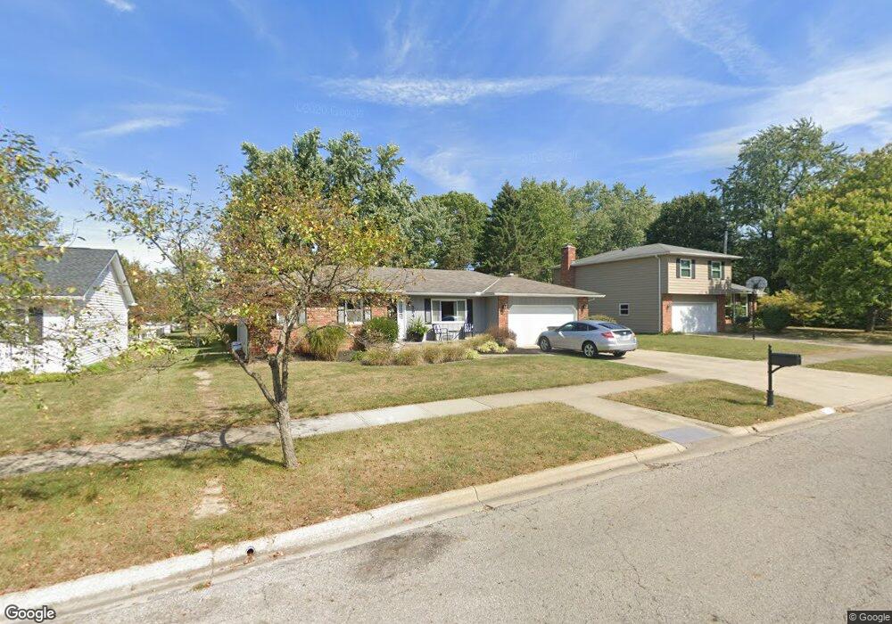
594 Michael Ave Westerville, OH 43081
Estimated Value: $363,907 - $392,000
3
Beds
2
Baths
1,500
Sq Ft
$252/Sq Ft
Est. Value
About This Home
This home is located at 594 Michael Ave, Westerville, OH 43081 and is currently estimated at $377,477, approximately $251 per square foot. 594 Michael Ave is a home located in Franklin County with nearby schools including Robert Frost Elementary School, Heritage Middle School, and Westerville-North High School.
Ownership History
Date
Name
Owned For
Owner Type
Purchase Details
Closed on
Jun 29, 2022
Sold by
Hale Howard Wayne and Hale Patty L
Bought by
Hale Family Trust and Hale
Current Estimated Value
Purchase Details
Closed on
Jun 4, 1985
Bought by
Hale H Wayne
Create a Home Valuation Report for This Property
The Home Valuation Report is an in-depth analysis detailing your home's value as well as a comparison with similar homes in the area
Home Values in the Area
Average Home Value in this Area
Purchase History
| Date | Buyer | Sale Price | Title Company |
|---|---|---|---|
| Hale Family Trust | -- | Hendrix Robert S | |
| Hale H Wayne | $73,500 | -- |
Source: Public Records
Tax History
| Year | Tax Paid | Tax Assessment Tax Assessment Total Assessment is a certain percentage of the fair market value that is determined by local assessors to be the total taxable value of land and additions on the property. | Land | Improvement |
|---|---|---|---|---|
| 2025 | $9,616 | $112,250 | $29,750 | $82,500 |
| 2024 | $9,616 | $112,250 | $29,750 | $82,500 |
| 2023 | $6,244 | $112,245 | $29,750 | $82,495 |
| 2022 | $5,118 | $70,250 | $17,150 | $53,100 |
| 2021 | $5,161 | $70,250 | $17,150 | $53,100 |
| 2020 | $5,146 | $70,250 | $17,150 | $53,100 |
| 2019 | $4,294 | $55,340 | $17,150 | $38,190 |
| 2018 | $4,306 | $55,340 | $17,150 | $38,190 |
| 2017 | $4,385 | $55,340 | $17,150 | $38,190 |
| 2016 | $4,546 | $54,220 | $17,710 | $36,510 |
| 2015 | $4,403 | $54,220 | $17,710 | $36,510 |
| 2014 | $4,406 | $54,220 | $17,710 | $36,510 |
| 2013 | $2,095 | $51,625 | $16,870 | $34,755 |
Source: Public Records
Map
Nearby Homes
- 629 Andrew Ave
- 138 Wood St
- 687 E College Ave
- 393 Canterbury Ct
- 852 Karen Ct
- 339 Aylesbury Dr S
- 328 Myrtle Dr Unit Lot 5
- 348 Myrtle Dr Unit Lot 10
- 337 Myrtle Dr Unit Lot 2
- 334 Myrtle Dr Unit Lot 7
- 342 Myrtle Dr Unit Lot 8
- 344 Myrtle Dr Unit Lot 9
- 373 Wyndham Park S
- 303 Pointe Place
- 291 Pointe Place
- 960 Lakeland Dr
- 266 Black Walnut Dr
- 660 Albion Place Unit 8660
- 961 E College Ave
- 448 Crossings Dr Unit 448
- 602 Michael Ave
- 586 Michael Ave
- 578 Michael Ave
- 601 Michael Ave
- 585 County Line Rd
- 583 Michael Ave
- 577 County Line Rd
- 570 Michael Ave
- 215 Murnane St
- 612 Michael Ave
- 304 Matthew Ave
- 303 Matthew Ave
- 567 Michael Ave
- 605 County Line Rd
- 207 Murnane St
- 296 Matthew Ave
- 564 Michael Ave
- 622 Michael Ave
- 295 Matthew Ave
- 536 Michael Ave
Your Personal Tour Guide
Ask me questions while you tour the home.