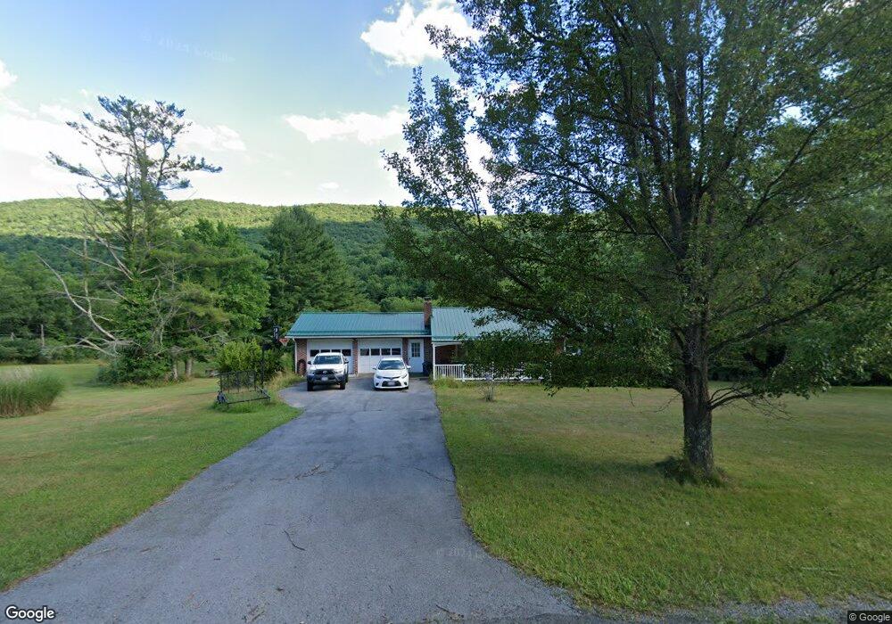
5940 Laurel Fork Rd Rocky Gap, VA 24366
Estimated Value: $193,000 - $285,000
5
Beds
2
Baths
2,420
Sq Ft
$92/Sq Ft
Est. Value
About This Home
This home is located at 5940 Laurel Fork Rd, Rocky Gap, VA 24366 and is currently estimated at $222,004, approximately $91 per square foot. 5940 Laurel Fork Rd is a home located in Bland County with nearby schools including Bland County Elementary School and Bland County High School.
Ownership History
Date
Name
Owned For
Owner Type
Purchase Details
Closed on
Aug 12, 2014
Sold by
Stowers James D and Stowers Darlene M
Bought by
Stowers James D
Current Estimated Value
Purchase Details
Closed on
Nov 23, 2010
Sold by
Federal Home Loan Mortgage Corporation
Bought by
Stowers James D
Home Financials for this Owner
Home Financials are based on the most recent Mortgage that was taken out on this home.
Original Mortgage
$80,325
Interest Rate
4.3%
Purchase Details
Closed on
Jul 19, 2010
Sold by
Stanley William and Bac Home Loans Servicing Lp
Bought by
Federal Home Loan Mortgage Corporation
Purchase Details
Closed on
Jan 4, 2007
Sold by
Gills Virginia R
Bought by
Stanley William
Home Financials for this Owner
Home Financials are based on the most recent Mortgage that was taken out on this home.
Original Mortgage
$193,500
Interest Rate
6.24%
Create a Home Valuation Report for This Property
The Home Valuation Report is an in-depth analysis detailing your home's value as well as a comparison with similar homes in the area
Purchase History
| Date | Buyer | Sale Price | Title Company |
|---|---|---|---|
| Stowers James D | -- | -- | |
| Stowers James D | $94,500 | -- | |
| Federal Home Loan Mortgage Corporation | $174,600 | -- | |
| Stanley William | $215,000 | -- |
Source: Public Records
Mortgage History
| Date | Status | Borrower | Loan Amount |
|---|---|---|---|
| Previous Owner | Stanley William | $80,325 | |
| Previous Owner | Stanley William | $193,500 |
Source: Public Records
Tax History
| Year | Tax Paid | Tax Assessment Tax Assessment Total Assessment is a certain percentage of the fair market value that is determined by local assessors to be the total taxable value of land and additions on the property. | Land | Improvement |
|---|---|---|---|---|
| 2025 | $807 | $134,500 | $26,100 | $108,400 |
| 2024 | $807 | $134,500 | $26,100 | $108,400 |
| 2023 | $807 | $134,500 | $26,100 | $108,400 |
| 2022 | $807 | $134,500 | $26,100 | $108,400 |
| 2021 | $807 | $134,500 | $26,100 | $108,400 |
| 2020 | $807 | $134,500 | $26,100 | $108,400 |
| 2019 | $816 | $136,000 | $26,100 | $109,900 |
| 2018 | $816 | $136,000 | $26,100 | $109,900 |
| 2017 | $816 | $136,000 | $26,100 | $109,900 |
| 2016 | $816 | $136,000 | $26,100 | $109,900 |
| 2015 | -- | $0 | $0 | $0 |
| 2014 | -- | $0 | $0 | $0 |
| 2013 | -- | $0 | $0 | $0 |
Source: Public Records
Map
Nearby Homes
- TBD Laurel Fork Rd
- 5380 Laurel Fork Rd
- 5380 Laurel Fork Rd
- 92 Acres Laurel Fork Rd
- 4694 Laurel Fork Rd
- 4431 E Cumberland Rd
- 59 Chaucer Rd
- 2804 Grassy Branch Rd
- 1405 Heatherwood Rd
- 1231 Sunrise Dr
- 2424 Fairfield Ave
- 28 Fernwood Dr
- 2732 Longview Terrace
- 116 Atomic Ct
- 727 Heatherwood Rd
- 83 Sparrow Ln
- 2917 Bland St
- 2616 Clovis St
- 2815 Bland Rd
- 1000 Union St
- 21 Poplar Ln
- 5974 Laurel Fork Rd
- 5895 Laurel Fork Rd
- 5992 Laurel Fork Rd
- 5852 Laurel Fork Rd
- 6023 Laurel Fork Rd
- 37 Cedar Ln
- 211 Honeysuckle Ln
- 105 Poplar Ln
- 5801 Laurel Fork Rd
- 77 Poplar Ln
- 5788 Laurel Fork Rd
- 32 Cedar Ln
- 153 Honeysuckle Ln
- 151 Poplar Ln
- 6165 Laurel Fork Rd
- 5753 Laurel Fork Rd
- HWY 613 Laurel Fork Rd
- 000 Laurel Fork Rd
- 00 Laurel Fork Rd
Your Personal Tour Guide
Ask me questions while you tour the home.