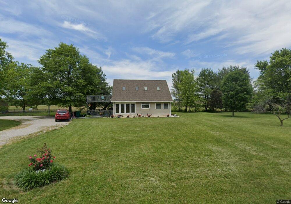
5941 Rolling Hills Ln Belleville, IL 62223
Estimated Value: $251,000 - $325,000
Studio
--
Bath
612
Sq Ft
$445/Sq Ft
Est. Value
About This Home
This home is located at 5941 Rolling Hills Ln, Belleville, IL 62223 and is currently estimated at $272,181, approximately $444 per square foot. 5941 Rolling Hills Ln is a home located in St. Clair County with nearby schools including Millstadt Consolidated School, Millstadt Primary Center, and Our Lady Queen Of Peace Catholic School.
Ownership History
Date
Name
Owned For
Owner Type
Purchase Details
Closed on
Apr 18, 2024
Sold by
Simpson Julie and Hodkinson Tasha N
Bought by
Simpson Julie
Current Estimated Value
Purchase Details
Closed on
Sep 28, 2005
Sold by
Hodgkinson James T and Hodgkinson Suzanne
Bought by
County Of St Clair
Purchase Details
Closed on
Mar 1, 1997
Bought by
Hodgkinson James T and Hodgkinson Suzanne
Create a Home Valuation Report for This Property
The Home Valuation Report is an in-depth analysis detailing your home's value as well as a comparison with similar homes in the area
Home Values in the Area
Average Home Value in this Area
Purchase History
| Date | Buyer | Sale Price | Title Company |
|---|---|---|---|
| Simpson Julie | -- | None Available | |
| County Of St Clair | $2,750 | -- | |
| Hodgkinson James T | $27,000 | -- |
Source: Public Records
Tax History
| Year | Tax Paid | Tax Assessment Tax Assessment Total Assessment is a certain percentage of the fair market value that is determined by local assessors to be the total taxable value of land and additions on the property. | Land | Improvement |
|---|---|---|---|---|
| 2024 | $4,909 | $79,833 | $8,572 | $71,261 |
| 2023 | $4,536 | $71,631 | $7,691 | $63,940 |
| 2022 | $4,224 | $65,001 | $6,979 | $58,022 |
| 2021 | $3,341 | $60,348 | $6,479 | $53,869 |
| 2020 | $3,362 | $59,127 | $6,304 | $52,823 |
| 2019 | $3,390 | $59,127 | $6,304 | $52,823 |
| 2018 | $3,433 | $56,500 | $6,024 | $50,476 |
| 2017 | $3,523 | $52,619 | $5,610 | $47,009 |
| 2016 | $3,382 | $52,045 | $4,919 | $47,126 |
| 2014 | $3,537 | $52,343 | $4,947 | $47,396 |
| 2013 | $3,652 | $55,844 | $5,278 | $50,566 |
Source: Public Records
Map
Nearby Homes
- 6009 Rolling Hills Ln
- 4411 Maple Brook Dr
- 2177 Southern Oak Cir
- 130 Dianne Dr
- 1374 Rocky Creek Ct
- 49 Dianne Dr
- 1366 Radden Ct
- 1800 Roosevelt Ave
- 1801 Roosevelt Ave
- 539 S 21st St
- 2704 Hibank Ct
- 109 Pecan Ln
- 178 Wyndrose Estates Dr
- 516 S 16th St
- 503 S 16th St
- 421 S 20th St
- 1309 Veile Dr
- 245 Summers Trace
- 1210 3rd Ave
- 408 S 15th St
- 5962 Rolling Hills Ln
- 4649 Frank Scott Pkwy W
- 4585 Frank Scott Pkwy W
- 4616 Frank Scott Pkwy W
- 4561 Frank Scott Pkwy W
- 5990 Rolling Hills Ln
- 4710 Frank Scott Pkwy W
- 6010 Rolling Hills Ln
- 4734 Frank Scott Pkwy W
- 6001 Concordia Rd
- 4700 Frank Scott Pkwy W
- 4526 Frank Scott Pkwy W
- 4534 Frank Scott Pkwy W
- 4530 Frank Scott Pkwy W
- 0 Concordia Church Rd Unit 16052544
- 0 Concordia Church Rd Unit 16052541
- 0 Concordia Church Rd Unit 17008184
- 5801 Concordia Rd
- 4696 Frank Scott Pkwy W
- 4704 Frank Scott Pkwy W
Your Personal Tour Guide
Ask me questions while you tour the home.