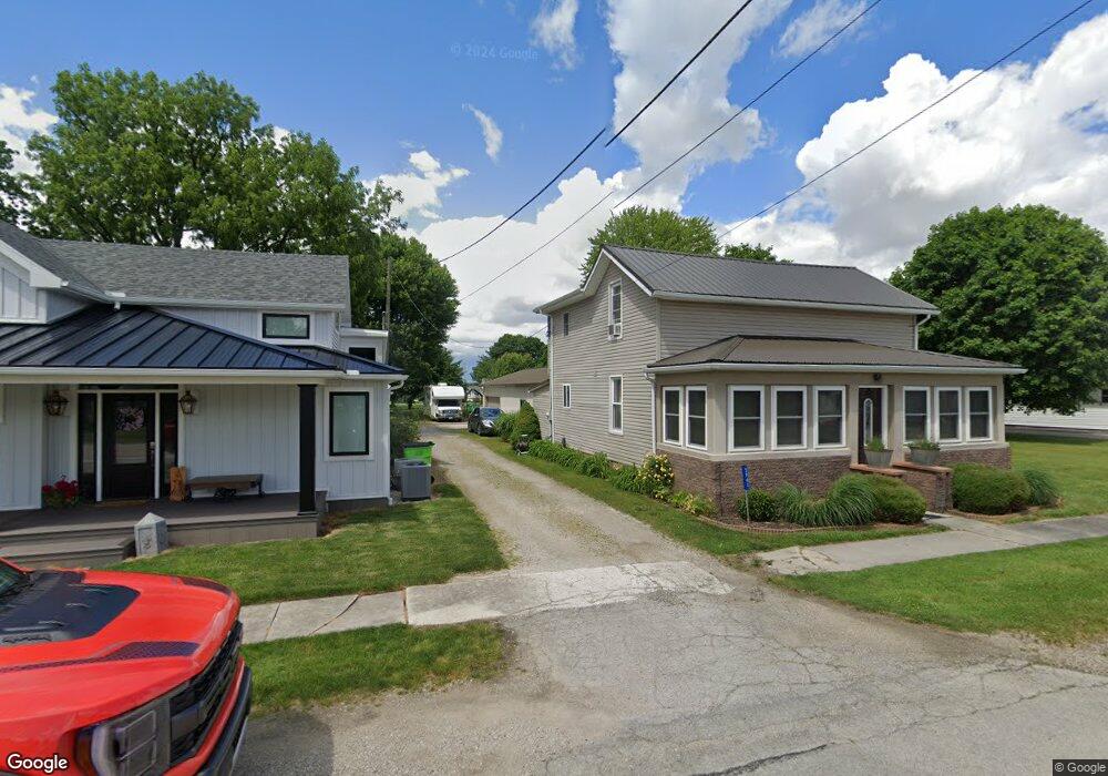
5941 W State Route 635 Kansas, OH 44841
Estimated Value: $131,000 - $177,000
3
Beds
1
Bath
1,344
Sq Ft
$119/Sq Ft
Est. Value
About This Home
This home is located at 5941 W State Route 635, Kansas, OH 44841 and is currently estimated at $159,833, approximately $118 per square foot. 5941 W State Route 635 is a home located in Seneca County with nearby schools including Lakota Elementary School, Lakota Middle School, and Lakota High School.
Ownership History
Date
Name
Owned For
Owner Type
Purchase Details
Closed on
Oct 18, 2024
Sold by
Johnson Steven D and Johnson Kimberly A
Bought by
Paxton Jeffrey L and Paxton Jennifer A
Current Estimated Value
Purchase Details
Closed on
Jun 17, 1997
Sold by
Mcelhaney Loren A
Bought by
Johnson Steven D
Purchase Details
Closed on
Jan 29, 1997
Sold by
Mcelhaney Loren A
Bought by
Mcelhaney Loren A
Purchase Details
Closed on
Oct 17, 1996
Sold by
Mcelhaney Loren A
Bought by
Mcelhaney Loren A
Create a Home Valuation Report for This Property
The Home Valuation Report is an in-depth analysis detailing your home's value as well as a comparison with similar homes in the area
Home Values in the Area
Average Home Value in this Area
Purchase History
| Date | Buyer | Sale Price | Title Company |
|---|---|---|---|
| Paxton Jeffrey L | $170,000 | Assured Title | |
| Paxton Jeffrey L | $170,000 | Assured Title | |
| Johnson Steven D | $24,000 | -- | |
| Mcelhaney Loren A | -- | -- | |
| Mcelhaney Loren A | -- | -- |
Source: Public Records
Tax History Compared to Growth
Tax History
| Year | Tax Paid | Tax Assessment Tax Assessment Total Assessment is a certain percentage of the fair market value that is determined by local assessors to be the total taxable value of land and additions on the property. | Land | Improvement |
|---|---|---|---|---|
| 2024 | $1,221 | $33,600 | $2,810 | $30,790 |
| 2023 | $1,206 | $33,600 | $2,810 | $30,790 |
| 2022 | $1,057 | $25,290 | $2,410 | $22,880 |
| 2021 | $1,024 | $25,290 | $2,410 | $22,880 |
| 2020 | $995 | $25,288 | $2,408 | $22,880 |
| 2019 | $859 | $21,991 | $2,097 | $19,894 |
| 2018 | $859 | $21,991 | $2,097 | $19,894 |
| 2017 | $845 | $21,991 | $2,097 | $19,894 |
| 2016 | $794 | $21,291 | $2,097 | $19,194 |
| 2015 | $845 | $21,291 | $2,097 | $19,194 |
| 2014 | $771 | $21,291 | $2,097 | $19,194 |
| 2013 | $781 | $21,291 | $2,097 | $19,194 |
Source: Public Records
Map
Nearby Homes
- 0 State Route 224 Unit 20240095
- 230 State St
- 203 Washington St
- 8399 N County Road 31
- 0 State Route 590 Unit 6136844
- 2595 County Road 13
- 4885 N Township Road 101
- 2231 County Road 23
- N Township Rd 45
- 6610 County Road 1
- 132 E Township Road 152
- 5479 N State Route 53
- 227 Main St
- 2821 N County Road 11
- 000 Weaver Rd
- 0000 Weaver Rd
- 0 Girton Rd
- 855 Rambo Ln
- 17 Adams Dr
- 8763 N Fostoria Rd
- 5953 W State Route 635
- 5925 W State Route 635
- 5925 Ohio 635
- 5965 Ohio 635
- 5905 Ohio 635
- 5905 W State Route 635
- 5895 W State Route 635
- 3 N State Route 635
- 5934 W State Route 635
- 5968 W State Route 635
- 5906 Ash St
- 5958 W State Route 635
- 5946 W State Route 635
- 5885 W State Route 635
- 5884 N Tr 1016 St
- 5885 Ohio 635
- 5980 W State Route 635
- 5982 N State Route 635
- 5894 Ash St
- 5929 N Tr 1016 St