Estimated Value: $322,331 - $349,000
4
Beds
2
Baths
1,696
Sq Ft
$201/Sq Ft
Est. Value
About This Home
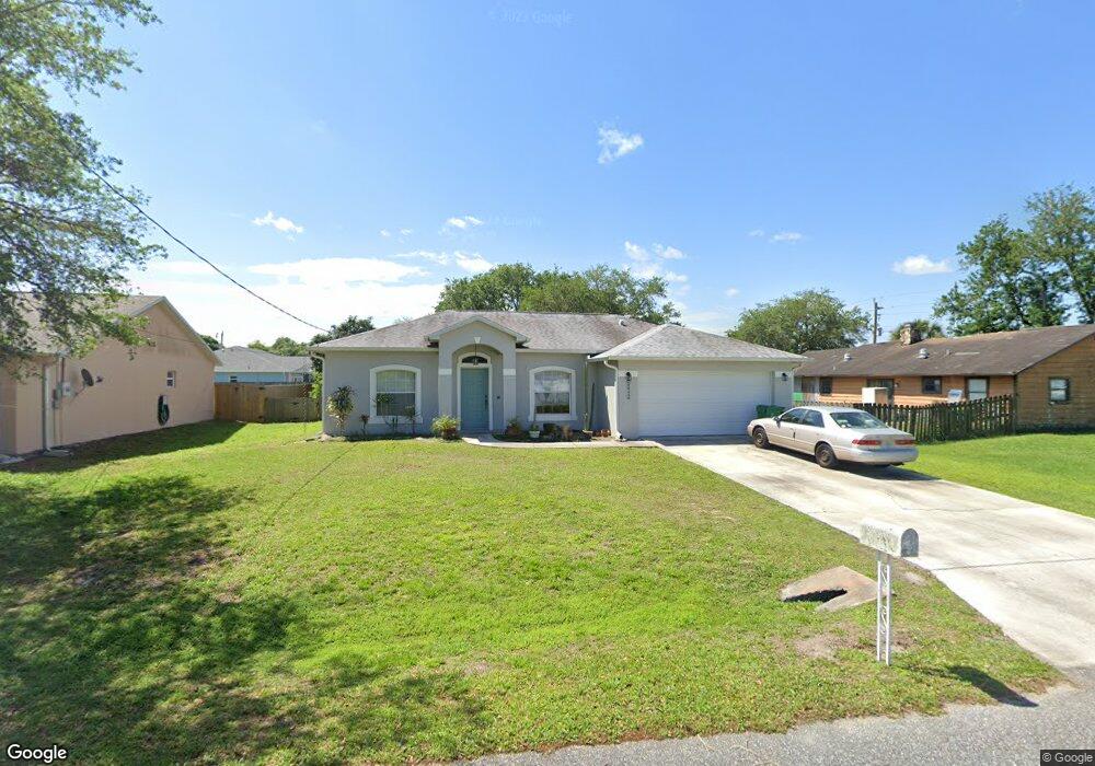
This home is located at 5945 Aruin St, Cocoa, FL 32927 and is currently estimated at $340,333, approximately $200 per square foot. 5945 Aruin St is a home located in Brevard County with nearby schools including Enterprise Elementary School, Space Coast Junior/Senior High School, and East Atlantic Prep of Brevard County.
Ownership History
Date
Name
Owned For
Owner Type
Purchase Details
Closed on
Dec 4, 1997
Sold by
Holiday Bldr Inc
Bought by
Bell Kevin L and Bell Mercedes G
Current Estimated Value
Home Financials for this Owner
Home Financials are based on the most recent Mortgage that was taken out on this home.
Original Mortgage
$79,400
Outstanding Balance
$13,611
Interest Rate
7.38%
Estimated Equity
$326,722
Purchase Details
Closed on
Aug 14, 1997
Sold by
Fleming Daniel M
Bought by
Holiday Bldr Inc
Create a Home Valuation Report for This Property
The Home Valuation Report is an in-depth analysis detailing your home's value as well as a comparison with similar homes in the area
Home Values in the Area
Average Home Value in this Area
Purchase History
| Date | Buyer | Sale Price | Title Company |
|---|---|---|---|
| Bell Kevin L | $84,000 | -- | |
| Holiday Bldr Inc | $8,000 | -- |
Source: Public Records
Mortgage History
| Date | Status | Borrower | Loan Amount |
|---|---|---|---|
| Open | Bell Kevin L | $79,400 |
Source: Public Records
Tax History Compared to Growth
Tax History
| Year | Tax Paid | Tax Assessment Tax Assessment Total Assessment is a certain percentage of the fair market value that is determined by local assessors to be the total taxable value of land and additions on the property. | Land | Improvement |
|---|---|---|---|---|
| 2025 | $1,364 | $98,800 | -- | -- |
| 2024 | $1,327 | $96,020 | -- | -- |
| 2023 | $1,327 | $93,230 | $0 | $0 |
| 2022 | $1,236 | $90,520 | $0 | $0 |
| 2021 | $1,229 | $87,890 | $0 | $0 |
| 2020 | $1,165 | $86,680 | $0 | $0 |
| 2019 | $1,100 | $84,740 | $0 | $0 |
| 2018 | $1,091 | $83,160 | $0 | $0 |
| 2017 | $1,081 | $81,450 | $0 | $0 |
| 2016 | $1,079 | $79,780 | $18,000 | $61,780 |
| 2015 | $1,088 | $79,230 | $15,000 | $64,230 |
| 2014 | $1,087 | $78,610 | $11,000 | $67,610 |
Source: Public Records
Map
Nearby Homes
- 6365 Homestead Ave
- 23-35-21-JX-B-2 Aruin St
- 6545 Addie Ave
- 6309 Alleghany Ave
- 6010 Fay Blvd
- 5715 Fairbridge St
- 6665 Addie Ave
- 4650 N Highway 1 Hwy
- 6105 Banyan St
- 6198 Dees Rd
- 5575 Curtis Blvd
- 6115 Allmont St
- 6643 Emil Ave
- 6003 Gilson
- 6581 Bancroft Ave
- 6118 Dees Rd
- 5955 Keystone Ave
- 6295 Banyan St
- 5940 Flamingo Ave
- 6017 Flamingo Ave
- 5935 Aruin St
- 6368 Bamboo Ave
- 6345 Homestead Ave
- 6422 Bamboo Ave
- 5905 Aruin St
- 6415 Homestead Ave
- 6356 Bamboo Ave
- 6325 Homestead Ave
- 5925 Aruin St
- 6434 Bamboo Ave
- 6425 Homestead Ave
- 6369 Bamboo Ave
- 5975 Aruin St
- 6344 Bamboo Ave
- 6305 Homestead Ave
- 6423 Bamboo Ave
- 6357 Bamboo Ave
- 5915 Aruin St
- 0 Aruin Homestead
- 6410 Homestead Ave