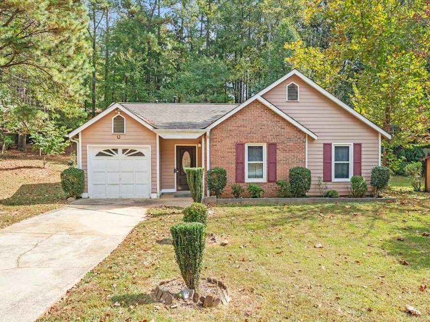
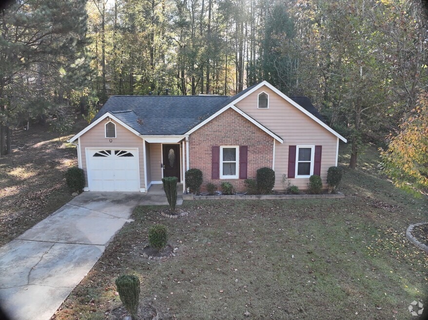

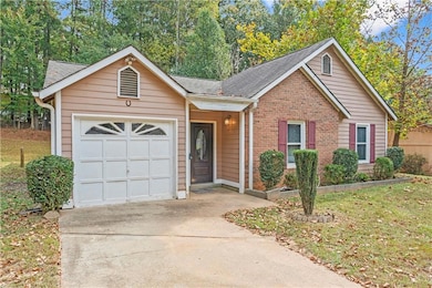
5947 Rock Rd Union City, GA 30291
Estimated payment $1,361/month
Highlights
- Hot Property
- Vaulted Ceiling
- Solid Surface Countertops
- Open-Concept Dining Room
- Ranch Style House
- Neighborhood Views
About This Home
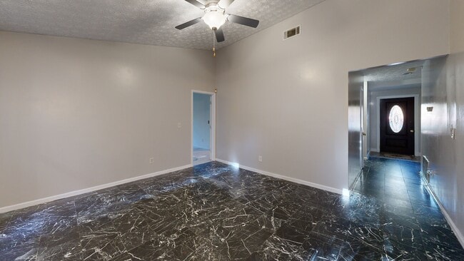
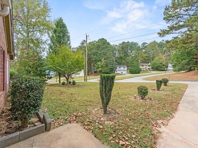
Welcome to this inviting ranch-style home featuring 3 bedrooms and 2 full baths. Conveniently located just minutes from Hartsfield-Jackson Airport, major highways, and in a community with no HOA — a perfect opportunity for first-time homebuyers or anyone looking to add their personal touch. The home features vaulted ceilings in both the living room and primary bedroom, enhancing the open and spacious layout. Enjoy the outdoors with an open front and back yard, along with a rear covered patio, perfect for family gatherings or relaxing. Property also offers a garage with a driveway that fits two additional vehicles. While the property requires some TLC, it presents outstanding potential for the right buyer to make it their own. SOLD AS-IS.
Home Details
Home Type
- Single Family
Est. Annual Taxes
- $2,106
Year Built
- Built in 1987
Lot Details
- 0.36 Acre Lot
- Level Lot
- Open Lot
- Cleared Lot
- Back and Front Yard
Parking
- 1 Car Garage
- Driveway Level
- On-Street Parking
Home Design
- Ranch Style House
- Traditional Architecture
- Brick Exterior Construction
- Frame Construction
- Shingle Roof
- Asbestos Shingle Roof
- Shingle Siding
- Concrete Perimeter Foundation
Interior Spaces
- 1,240 Sq Ft Home
- Vaulted Ceiling
- Shutters
- Family Room with Fireplace
- Living Room with Fireplace
- Open-Concept Dining Room
- Neighborhood Views
- Fire and Smoke Detector
Kitchen
- Breakfast Bar
- Gas Range
- Microwave
- Solid Surface Countertops
- White Kitchen Cabinets
Flooring
- Tile
- Vinyl
Bedrooms and Bathrooms
- 3 Main Level Bedrooms
- 2 Full Bathrooms
- Vaulted Bathroom Ceilings
- Bathtub and Shower Combination in Primary Bathroom
Laundry
- Laundry Room
- Laundry in Hall
- Laundry on main level
Outdoor Features
- Covered Patio or Porch
- Shed
- Rain Gutters
Schools
- Liberty Point Elementary School
- Camp Creek Middle School
- Langston Hughes High School
Utilities
- Forced Air Heating and Cooling System
- 110 Volts
- Cable TV Available
Community Details
- Wellington Estates Subdivision
Listing and Financial Details
- Legal Lot and Block 53 / B
- Assessor Parcel Number 09F210300980315
3D Interior and Exterior Tours
Floorplan
Map
Home Values in the Area
Average Home Value in this Area
Tax History
| Year | Tax Paid | Tax Assessment Tax Assessment Total Assessment is a certain percentage of the fair market value that is determined by local assessors to be the total taxable value of land and additions on the property. | Land | Improvement |
|---|---|---|---|---|
| 2025 | $977 | $62,840 | $18,240 | $44,600 |
| 2023 | $977 | $67,920 | $21,320 | $46,600 |
| 2022 | $1,238 | $47,040 | $13,760 | $33,280 |
| 2021 | $960 | $35,400 | $8,560 | $26,840 |
| 2020 | $973 | $35,000 | $8,480 | $26,520 |
| 2019 | $1,105 | $26,160 | $6,040 | $20,120 |
| 2018 | $581 | $20,600 | $3,280 | $17,320 |
| 2017 | $601 | $20,600 | $3,280 | $17,320 |
| 2016 | $703 | $24,080 | $5,280 | $18,800 |
| 2015 | $1,083 | $24,080 | $5,280 | $18,800 |
| 2014 | $443 | $14,440 | $2,160 | $12,280 |
Property History
| Date | Event | Price | List to Sale | Price per Sq Ft |
|---|---|---|---|---|
| 10/22/2025 10/22/25 | For Sale | $225,000 | -- | $181 / Sq Ft |
Purchase History
| Date | Type | Sale Price | Title Company |
|---|---|---|---|
| Warranty Deed | -- | -- | |
| Warranty Deed | $15,000 | -- | |
| Deed | -- | -- | |
| Deed | -- | -- | |
| Foreclosure Deed | $87,933 | -- | |
| Deed | $69,500 | -- |
Mortgage History
| Date | Status | Loan Amount | Loan Type |
|---|---|---|---|
| Closed | $0 | FHA |
About the Listing Agent

Carina Figueroa | Metro Atlanta Realtor Serving Henry, Spalding, and Clayton Counties
Carina Figueroa is a dedicated real estate agent proudly serving Henry, Spalding, and Clayton counties, along with the greater Metro Atlanta area. Since 2021, she has built a strong reputation for hard work, adaptability, and personalized service, guiding both buyers and sellers through every step of their real estate journey.
As a bilingual agent, Carina is especially passionate about supporting
Source: First Multiple Listing Service (FMLS)
MLS Number: 7669259
APN: 09F-2103-0098-031-5
Disclaimer: Certain information contained herein is derived from information provided by parties other than Homes.com. All information provided is deemed reliable, but is not guaranteed to be accurate and should be independently verified.
![]() Listings identified with the FMLS IDX logo come from FMLS and are held by brokerage firms other than the owner of this website. The listing brokerage is identified in any listing details. Information is deemed reliable but is not guaranteed. If you believe any FMLS listing contains material that infringes your copyrighted work please visit www.fmls.com/dmca to review our DMCA policy and learn how to submit a takedown request. © 2025 First Multiple Listing Service, Inc.
Listings identified with the FMLS IDX logo come from FMLS and are held by brokerage firms other than the owner of this website. The listing brokerage is identified in any listing details. Information is deemed reliable but is not guaranteed. If you believe any FMLS listing contains material that infringes your copyrighted work please visit www.fmls.com/dmca to review our DMCA policy and learn how to submit a takedown request. © 2025 First Multiple Listing Service, Inc.
- 5910 Rock Rd
- 5856 Rock Rd
- 3227 Diamond Bluff
- 4485 Ravenwood Dr
- 6000 Diamond Ln
- 6024 Diamond Ln
- 0 Lower Dixie Lake Rd Unit 22475153
- 0 Lower Dixie Lake Rd Unit 7515143
- 0 Lakeside Dr Unit 22475152
- 0 Lakeside Dr Unit 7515650
- 5848 Union Walk Dr
- 000 Highpoint Rd
- 99 Highpoint Rd
- 4611 Ravenwood Loop
- 0 Highpoint Rd Unit 10553938
- 5642 Union Pointe Dr
- 4615 Ravenwood Loop
- 5552 Lakeside Dr
- 5545 Union Pointe Place
- 4443 Manor Hill Dr
- 5729 Rock Rd
- 3250 Diamond Bluff
- 5556 Liberty Rd
- 3408 Newgold Trace
- 3408 Newgold Terrace
- 3424 Newgold Terrace
- 4614 Raven Wood Loop
- 4614 Ravenwood Loop
- 3120 Far Emerald Land
- 3129 Far Emerald Land
- 4520 Ravenwood Place
- 5787 Blacktop Ct
- 4136 Ravenwood Ct
- 5952 Stonewall Dr
- 9555 Lakeview Cir
- 6064 Redtop Loop
- 5736 Lakeside Dr
- 9448 Lakeview Rd
- 5853 Black Top Way
- 10320 Deep Creek Cove