R
Seller's Agent in 2025
Robert Davis
West Investment Group LLC
(248) 762-9133
2 in this area
3 Total Sales
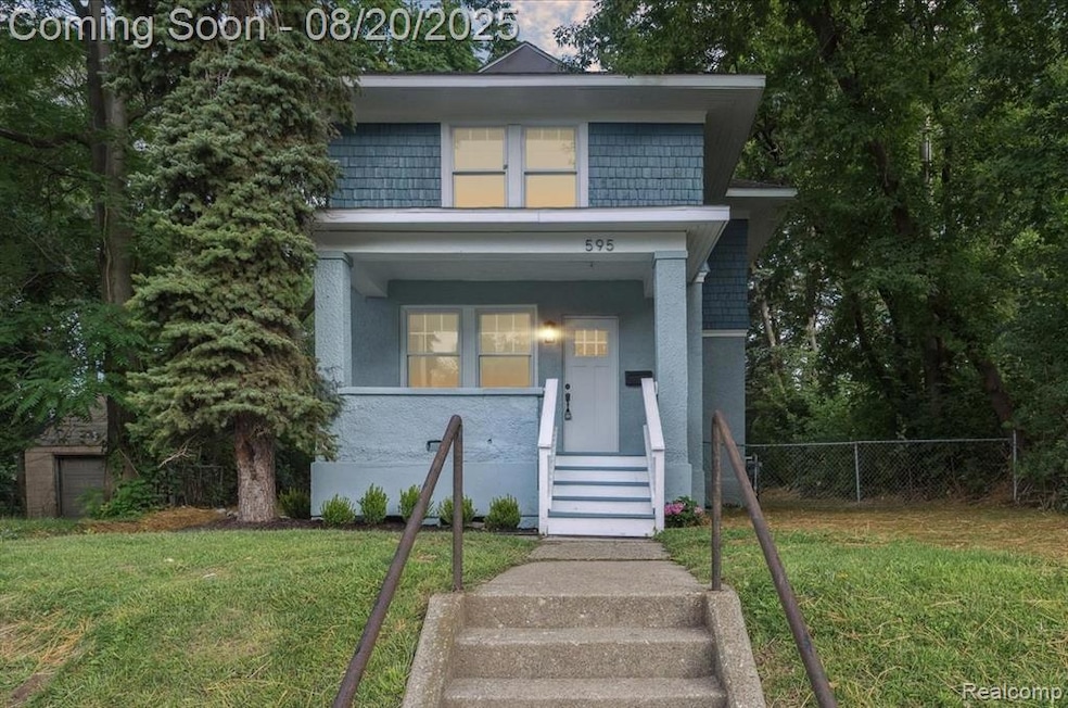
Completely renovated colonial in the GM Modern Housing Historic District—like a brand-new home! This turnkey property features all new windows, roof, doors, paint, flooring, light fixtures, kitchen cabinets, granite countertops, appliances, updated bathrooms, and refinished original hardwood upstairs. Major system upgrades include new plumbing, electrical, hot water tank, furnace and A/C. Huge back yard that’s perfect for a fenced yard, future garage or garden space. Located minutes from Woodward Loop, M-59, and I-75. Ideal for first time home buyers or anyone looking for a move-in ready home with space to grow!
Last Agent to Sell the Property
West Investment Group LLC License #6502433501 Listed on: 08/20/2025
| Date | Type | Sale Price | Title Company |
|---|---|---|---|
| Contract Of Sale | -- | None Listed On Document | |
| Warranty Deed | $160,000 | None Listed On Document | |
| Warranty Deed | $160,000 | None Listed On Document | |
| Quit Claim Deed | -- | None Listed On Document | |
| Quit Claim Deed | -- | None Listed On Document | |
| Quit Claim Deed | -- | None Listed On Document | |
| Deed | $60,000 | -- | |
| Deed | $53,000 | -- | |
| Deed | $24,000 | -- |
| Date | Status | Loan Amount | Loan Type |
|---|---|---|---|
| Previous Owner | $51,000 | No Value Available | |
| Closed | -- | No Value Available |
| Date | Event | Price | List to Sale | Price per Sq Ft |
|---|---|---|---|---|
| 09/09/2025 09/09/25 | Sold | $160,000 | -10.9% | $150 / Sq Ft |
| 08/28/2025 08/28/25 | Pending | -- | -- | -- |
| 08/20/2025 08/20/25 | For Sale | $179,500 | -- | $168 / Sq Ft |
| Year | Tax Paid | Tax Assessment Tax Assessment Total Assessment is a certain percentage of the fair market value that is determined by local assessors to be the total taxable value of land and additions on the property. | Land | Improvement |
|---|---|---|---|---|
| 2025 | -- | $43,050 | $0 | $0 |
| 2024 | -- | $0 | $0 | $0 |
| 2023 | -- | $0 | $0 | $0 |
| 2022 | $0 | $0 | $0 | $0 |
| 2021 | $247 | $0 | $0 | $0 |
| 2020 | $247 | $0 | $0 | $0 |
| 2019 | $247 | $0 | $0 | $0 |
| 2018 | $0 | $0 | $0 | $0 |
| 2017 | $247 | $0 | $0 | $0 |
| 2016 | $247 | $0 | $0 | $0 |
| 2015 | -- | $12,360 | $0 | $0 |
| 2014 | -- | $10,880 | $0 | $0 |
| 2011 | -- | $17,300 | $0 | $0 |
R
Seller's Agent in 2025
Robert Davis
West Investment Group LLC
(248) 762-9133
2 in this area
3 Total Sales

Buyer's Agent in 2025
Eric Martin
Max Broock, REALTORS®-Birmingham
(248) 818-4184
2 in this area
33 Total Sales
Source: Realcomp
MLS Number: 20251027264
APN: 14-21-376-031
Disclaimer: Certain information contained herein is derived from information provided by parties other than Homes.com. All information provided is deemed reliable, but is not guaranteed to be accurate and should be independently verified.
![]() IDX provided courtesy of Realcomp II Ltd. via Ten-X and MLS
IDX provided courtesy of Realcomp II Ltd. via Ten-X and MLS
Copyright 2026 Realcomp II Ltd. Shareholders
IDX information is provided exclusively for consumers' personal, noncommercial use and may not be used for any purpose other than to identify prospective properties consumers may be interested in purchasing. The accuracy of all information, regardless of source, is not guaranteed or warranted. All information should be independently verified.
Listing Information presented by local MLS brokerage: Ten-X, local REALTOR®- Arlene Richardson - (888)-952-6393
Ask me questions while you tour the home.