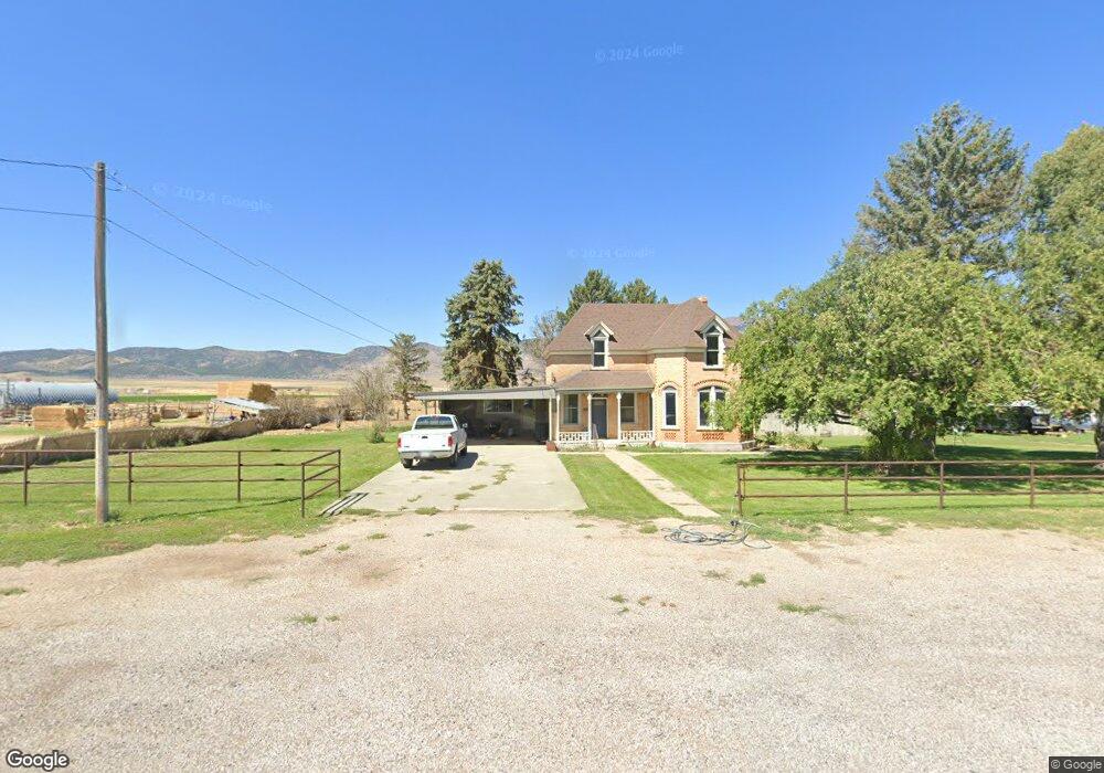
595 N State St Scipio, UT 84656
Estimated Value: $361,000 - $463,000
5
Beds
1
Bath
2,522
Sq Ft
$164/Sq Ft
Est. Value
About This Home
This home is located at 595 N State St, Scipio, UT 84656 and is currently estimated at $414,237, approximately $164 per square foot. 595 N State St is a home located in Millard County.
Ownership History
Date
Name
Owned For
Owner Type
Purchase Details
Closed on
Jun 8, 2018
Sold by
Shupe Lori J
Bought by
Shupe Lori J and Shupe Jerry Dean
Current Estimated Value
Purchase Details
Closed on
Apr 17, 2017
Sold by
Monroe Michael J and Monroe Jamie L
Bought by
Monroe Michael
Home Financials for this Owner
Home Financials are based on the most recent Mortgage that was taken out on this home.
Original Mortgage
$150,215
Interest Rate
4.3%
Mortgage Type
New Conventional
Purchase Details
Closed on
Feb 2, 2011
Sold by
Monroe Michael J
Bought by
Monroe Michaal J and Monroe Jamie L
Home Financials for this Owner
Home Financials are based on the most recent Mortgage that was taken out on this home.
Original Mortgage
$158,549
Interest Rate
4.74%
Mortgage Type
New Conventional
Create a Home Valuation Report for This Property
The Home Valuation Report is an in-depth analysis detailing your home's value as well as a comparison with similar homes in the area
Purchase History
| Date | Buyer | Sale Price | Title Company |
|---|---|---|---|
| Shupe Lori J | -- | Inwest Title | |
| Shupe Lori J | -- | -- | |
| Monroe Michael | -- | First American Title | |
| Monroe Michaal J | -- | -- | |
| Monroe Michael J | -- | -- |
Source: Public Records
Mortgage History
| Date | Status | Borrower | Loan Amount |
|---|---|---|---|
| Previous Owner | Monroe Michael | $150,215 | |
| Previous Owner | Monroe Michael J | $158,549 |
Source: Public Records
Tax History
| Year | Tax Paid | Tax Assessment Tax Assessment Total Assessment is a certain percentage of the fair market value that is determined by local assessors to be the total taxable value of land and additions on the property. | Land | Improvement |
|---|---|---|---|---|
| 2025 | $1,710 | $218,130 | $38,875 | $179,255 |
| 2024 | $1,710 | $212,221 | $41,142 | $171,079 |
| 2023 | $1,963 | $212,221 | $41,142 | $171,079 |
| 2022 | $1,655 | $151,901 | $41,141 | $110,760 |
| 2021 | $1,449 | $127,482 | $30,475 | $97,007 |
| 2020 | $1,332 | $118,074 | $26,500 | $91,574 |
| 2019 | $1,222 | $108,762 | $26,500 | $82,262 |
| 2018 | $1,032 | $93,969 | $26,500 | $67,469 |
| 2017 | $786 | $68,474 | $1,005 | $67,469 |
| 2016 | $596 | $53,958 | $1,005 | $52,953 |
| 2015 | $596 | $53,958 | $0 | $53,958 |
| 2014 | -- | $54,011 | $0 | $54,011 |
| 2013 | -- | $54,075 | $0 | $54,075 |
Source: Public Records
Map
Nearby Homes
- 240 W 300 North Rd
- 85 E 200 Rd N
- 7 N 200 W
- 40 S State St
- 2000 N 500 W
- 13051 Red Canyon Rd Unit 3
- Mecham Rd
- 575 N Deer Meadow Dr
- 445 S Main St
- 405 S 100 East St Unit 4
- 400 S 100 East St Unit 5
- Parcel 4609 4609x1 4609x2
- 66 W 100 S
- 41 N 450 W
- 117 E 300 S
- 36 W 100 S
- 21 N 450 W
- 80 N 400 W
- 340 E 300 S
- 155 S 200 W
- 575 N State St
- 600 N State St Unit 7
- 600 N State St Unit 8
- 600 N State St Unit 2
- 600 N State St Unit 4
- 600 N State St Unit 1
- 600 N State St Unit 6
- 600 N State St Unit 3
- 600 N State St Unit 5
- 600 N State St
- 545 N State St
- 500 N State St
- 710 N 100 E
- 540 N State St
- 525 N State St
- 506 N State St
- 65 E 500 N
- 70 W 500 N
- 85 E 500 Rd N
- 330-200e 200 E
Your Personal Tour Guide
Ask me questions while you tour the home.