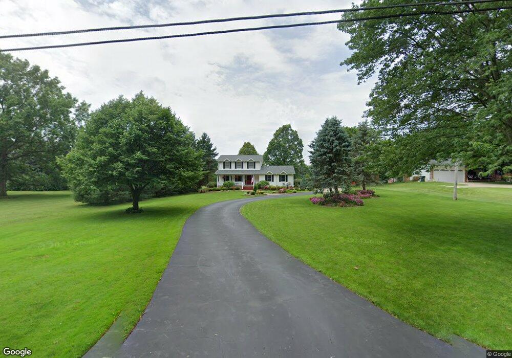
5950 Taylor Rd Doylestown, OH 44230
Estimated Value: $201,000 - $322,000
3
Beds
2
Baths
1,765
Sq Ft
$158/Sq Ft
Est. Value
About This Home
This home is located at 5950 Taylor Rd, Doylestown, OH 44230 and is currently estimated at $278,717, approximately $157 per square foot. 5950 Taylor Rd is a home located in Wayne County with nearby schools including Hazel Harvey Elementary School, Chippewa Intermediate School, and Chippewa Jr./Sr. High School.
Ownership History
Date
Name
Owned For
Owner Type
Purchase Details
Closed on
Oct 22, 1993
Sold by
Steiner Bruce E
Bought by
Steiner Bruce E and Steiner Robin M
Current Estimated Value
Purchase Details
Closed on
Oct 21, 1991
Sold by
Lucas Paul W
Bought by
Steiner Bruce E
Purchase Details
Closed on
Sep 13, 1990
Sold by
Anello Anthony and Anello Belinda
Bought by
Lucas Paul W
Purchase Details
Closed on
Jun 14, 1988
Sold by
Penko John and Penko Josephine T
Bought by
Anello Anthony and Anello Belinda
Create a Home Valuation Report for This Property
The Home Valuation Report is an in-depth analysis detailing your home's value as well as a comparison with similar homes in the area
Home Values in the Area
Average Home Value in this Area
Purchase History
We collect this data history from publicly available records. To have your information removed, we recommend requesting removal directly through your county’s website.
| Date | Buyer | Sale Price | Title Company |
|---|---|---|---|
| Steiner Bruce E | -- | -- | |
| Steiner Bruce E | $117,000 | -- | |
| Lucas Paul W | $14,000 | -- | |
| Anello Anthony | $8,200 | -- |
Source: Public Records
Tax History
| Year | Tax Paid | Tax Assessment Tax Assessment Total Assessment is a certain percentage of the fair market value that is determined by local assessors to be the total taxable value of land and additions on the property. | Land | Improvement |
|---|---|---|---|---|
| 2025 | $3,109 | $90,330 | $17,980 | $72,350 |
| 2024 | $3,109 | $90,330 | $17,980 | $72,350 |
| 2023 | $3,124 | $90,330 | $17,980 | $72,350 |
| 2022 | $2,336 | $61,870 | $12,310 | $49,560 |
| 2021 | $2,341 | $61,870 | $12,310 | $49,560 |
| 2020 | $2,357 | $61,870 | $12,310 | $49,560 |
| 2019 | $2,161 | $54,760 | $10,980 | $43,780 |
| 2018 | $2,182 | $54,760 | $10,980 | $43,780 |
| 2017 | $2,164 | $54,760 | $10,980 | $43,780 |
| 2016 | $2,108 | $52,650 | $10,560 | $42,090 |
| 2015 | $2,113 | $52,650 | $10,560 | $42,090 |
| 2014 | $1,855 | $52,650 | $10,560 | $42,090 |
| 2013 | $1,887 | $51,970 | $9,930 | $42,040 |
Source: Public Records
Map
Nearby Homes
- 6382 Kungle Rd
- 3097 Baughman Rd
- 14172 & 14174 Hametown Rd
- 568 Breiton Cir
- 15562 Portage St
- 407 31st St SW
- 2750 Himelrigh Blvd
- 2672 Lyman Dr
- 5263 Frederick St
- 5259 Frederick St
- 2721 Krska Place
- 5309 Miller St
- 2670 Himelrigh Blvd
- 000 Haynes Ave
- 1545 Ries St
- V/L Monroe Square
- 5245 Monroe Square E
- V/L Bishop Oval
- 14831 Calaboone Rd
- 669 Summit St
- 5942 Taylor Rd
- 5932 Taylor Rd
- 19120 Grill Rd
- 19092 Grill Rd
- 5952 Taylor Rd
- 5918 Taylor Rd
- 5906 Taylor Rd
- 6000 Taylor Rd
- 19046 Grill Rd
- 5919 Taylor Rd
- 5981 Taylor Rd
- 5954 Taylor Rd
- 3402 Lullaby Ln
- 3392 Lullaby Ln
- 5880 Taylor Rd
- 19009 Grill Rd
- 3376 Lullaby Ln
- 3377 Grill Rd
- 6033 Taylor Rd
- 6033 Taylor Rd
Your Personal Tour Guide
Ask me questions while you tour the home.