Estimated Value: $383,000 - $539,649
4
Beds
3
Baths
2,270
Sq Ft
$216/Sq Ft
Est. Value
About This Home
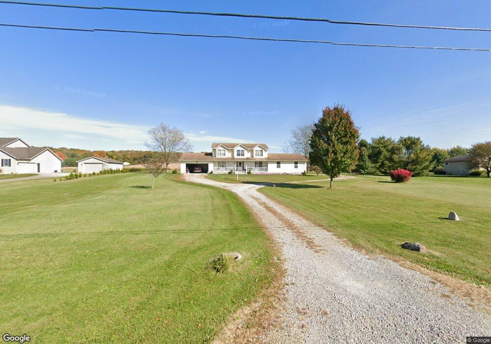
This home is located at 5951 S Fork Rd, Heath, OH 43056 and is currently estimated at $490,912, approximately $216 per square foot. 5951 S Fork Rd is a home located in Licking County with nearby schools including Jackson Intermediate School, Lakewood Middle School, and Lakewood High School.
Ownership History
Date
Name
Owned For
Owner Type
Purchase Details
Closed on
May 6, 2011
Sold by
Worth Lester D and Worth Isabelle June
Bought by
Ellinger Kelvin J and Ellinger Ginny R
Current Estimated Value
Home Financials for this Owner
Home Financials are based on the most recent Mortgage that was taken out on this home.
Original Mortgage
$196,000
Outstanding Balance
$136,085
Interest Rate
4.86%
Mortgage Type
New Conventional
Estimated Equity
$354,827
Create a Home Valuation Report for This Property
The Home Valuation Report is an in-depth analysis detailing your home's value as well as a comparison with similar homes in the area
Purchase History
| Date | Buyer | Sale Price | Title Company |
|---|---|---|---|
| Ellinger Kelvin J | $245,000 | Arrow Title |
Source: Public Records
Mortgage History
| Date | Status | Borrower | Loan Amount |
|---|---|---|---|
| Open | Ellinger Kelvin J | $196,000 |
Source: Public Records
Tax History
| Year | Tax Paid | Tax Assessment Tax Assessment Total Assessment is a certain percentage of the fair market value that is determined by local assessors to be the total taxable value of land and additions on the property. | Land | Improvement |
|---|---|---|---|---|
| 2024 | $5,076 | $134,860 | $27,130 | $107,730 |
| 2023 | $5,090 | $134,860 | $27,130 | $107,730 |
| 2022 | $7,549 | $106,960 | $17,360 | $89,600 |
| 2021 | $4,829 | $106,960 | $17,360 | $89,600 |
| 2020 | $4,838 | $106,960 | $17,360 | $89,600 |
| 2019 | $4,148 | $86,140 | $14,460 | $71,680 |
| 2018 | $4,193 | $0 | $0 | $0 |
| 2017 | $4,191 | $0 | $0 | $0 |
| 2016 | $3,852 | $0 | $0 | $0 |
| 2015 | $3,617 | $0 | $0 | $0 |
| 2014 | $5,584 | $0 | $0 | $0 |
| 2013 | $3,572 | $0 | $0 | $0 |
Source: Public Records
Map
Nearby Homes
- 307 Nicholas Dr Unit 46
- 92 Jonathan Dr
- 1285 Bluejack Ln
- 1265 Green Valley Dr
- 381 Laurel Oaks Ln
- 105 Clark Ave
- 602 Deanna Stroll Rd
- 399 Laurel Oaks Ln Unit Lot 131
- 403 Laurel Oaks Ln Unit Lot 132
- 6281 Davis Dr
- 625 Fulla Ln SE
- 14 Wesley Ave
- 164 Licking View Dr
- 2453 Ryan Rd
- 1094 Aldine Dr
- 944 Fieldson Dr
- 225 Pleasant Lee Dr
- 780 Fieldson Dr
- 233 Wildwood Ct Unit 233C
- 1230 Vista Dr
- 5887 S Fork Rd
- 5975 S Fork Rd
- 5960 S Fork Rd
- 5896 S Fork Rd
- 5247 White Chapel Rd
- 5247 White Chapel Rd SE
- 5211 White Chapel Rd
- 5269 White Chapel Rd
- 5240 White Chapel Rd SE
- 5240 White Chapel Rd
- 5766 S Fork Rd
- 5173 White Chapel Rd
- 5383 White Chapel Rd
- 5383 White Chapel Rd
- 5252 White Chapel Rd
- 5787 S Fork Rd
- 5775 S Fork Rd
- 5200 White Chapel Rd
- 5380 White Chapel Rd
- 5750 S Fork Rd
Your Personal Tour Guide
Ask me questions while you tour the home.