Estimated Value: $363,000 - $475,000
3
Beds
2
Baths
1,841
Sq Ft
$230/Sq Ft
Est. Value
About This Home
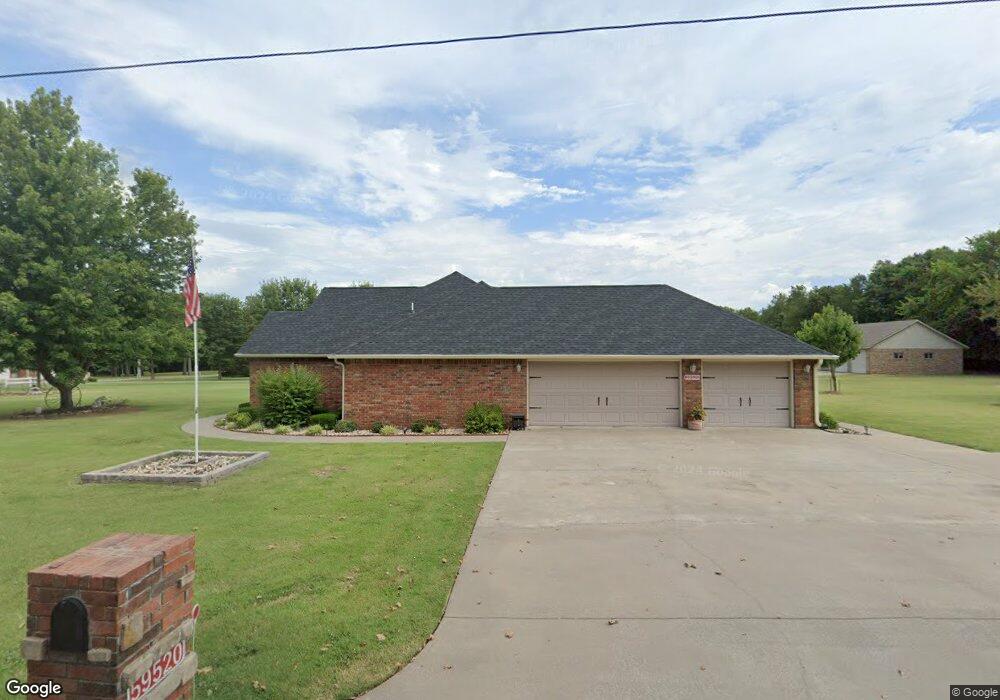
This home is located at 59520 E 290 Rd, Grove, OK 74344 and is currently estimated at $423,394, approximately $229 per square foot. 59520 E 290 Rd is a home located in Delaware County with nearby schools including Grove Lower Elementary School, Grove Upper Elementary School, and Grove Middle School.
Ownership History
Date
Name
Owned For
Owner Type
Purchase Details
Closed on
Aug 17, 2022
Sold by
Harper Kay E
Bought by
Housing Authority Of The Peoria Tribe Of Indi
Current Estimated Value
Purchase Details
Closed on
Jun 4, 2009
Sold by
Springston Mary E
Bought by
Harper Robert E and Harper Kay E
Purchase Details
Closed on
Aug 29, 2006
Sold by
Barnhart Phillip and Barnhart Catherine
Bought by
Springston Herman Jack and Springston Mary E
Create a Home Valuation Report for This Property
The Home Valuation Report is an in-depth analysis detailing your home's value as well as a comparison with similar homes in the area
Home Values in the Area
Average Home Value in this Area
Purchase History
| Date | Buyer | Sale Price | Title Company |
|---|---|---|---|
| Housing Authority Of The Peoria Tribe Of Indi | $24,984 | -- | |
| Harper Robert E | $215,000 | -- | |
| Springston Herman Jack | $206,000 | -- |
Source: Public Records
Tax History
| Year | Tax Paid | Tax Assessment Tax Assessment Total Assessment is a certain percentage of the fair market value that is determined by local assessors to be the total taxable value of land and additions on the property. | Land | Improvement |
|---|---|---|---|---|
| 2025 | $2,527 | $31,212 | $2,247 | $28,965 |
| 2024 | $2,407 | $29,726 | $2,140 | $27,586 |
| 2023 | $2,407 | $28,310 | $2,037 | $26,273 |
| 2022 | $2,168 | $27,771 | $2,013 | $25,758 |
| 2021 | $2,097 | $26,962 | $2,013 | $24,949 |
| 2020 | $2,068 | $25,415 | $2,013 | $23,402 |
| 2019 | $2,092 | $25,598 | $2,013 | $23,585 |
| 2018 | $2,024 | $24,852 | $2,013 | $22,839 |
| 2017 | $1,996 | $24,915 | $2,013 | $22,902 |
| 2016 | $1,935 | $23,737 | $2,013 | $21,724 |
| 2015 | $1,963 | $23,737 | $1,323 | $22,414 |
| 2014 | $1,972 | $23,737 | $1,323 | $22,414 |
Source: Public Records
Map
Nearby Homes
- TBD S 595 Cir
- 59399 E 288 Ct
- 59386 E 288 Ct
- 59396 E 288 Ct
- 4926 Lost Cove Rd
- 4967 Lighthouse Springs Dr
- 1513 Carey Dr
- 4971 Lighthouse Springs Dr
- 5013 Lake Breeze Rd
- 29880 S 592 Ln
- 29900 S 592 Place
- 1515 St Joseph Dr
- 622 Alpine Dr
- TBD S 592 Place
- 6026 Lake Breeze Rd
- 822 Chatsworth Dr
- TBD S 592 Lot 25 Place
- 827 Chatsworth Dr
- 1002 Poplar Ln
- TBD S 592 Lot 26
- 28842 S 595 Cir
- 28980 S 594 Ln
- 28960 S 594 Ln
- E E 290 Rd
- 59150 E 290 Rd
- 59160 E 290 Rd
- 28950 S 594 Ln
- 28961 S 594 Ln
- 28940 S 594 Ln
- 59341 E 289 Ct
- 59400 E 290 Rd
- 29068 S 595 Rd
- 0 S 594 Ln
- 0 E 290 Rd Unit 20-1016
- 0 E 290 Rd Unit 21-532
- 0 E 290 Rd Unit 1011359
- 59601 E 290 Rd
- 28920 S 594 Ln
- 28875 S 595 Cir
- 28910 S 594 Ln
Your Personal Tour Guide
Ask me questions while you tour the home.