Estimated Value: $1,620,000 - $2,222,000
4
Beds
5
Baths
6,431
Sq Ft
$305/Sq Ft
Est. Value
About This Home
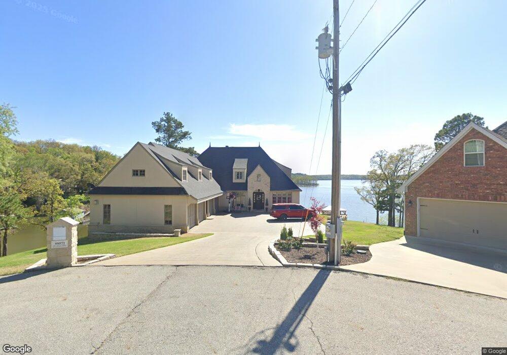
This home is located at 59571 E 317 Ln, Grove, OK 74344 and is currently estimated at $1,961,449, approximately $304 per square foot. 59571 E 317 Ln is a home located in Delaware County with nearby schools including Grove Lower Elementary School, Grove Upper Elementary School, and Grove Middle School.
Ownership History
Date
Name
Owned For
Owner Type
Purchase Details
Closed on
Sep 10, 2020
Sold by
Sanders Charles F and Sanders Joyce E
Bought by
Medlin Tyson R and Medlin Kari
Current Estimated Value
Home Financials for this Owner
Home Financials are based on the most recent Mortgage that was taken out on this home.
Original Mortgage
$1,190,000
Interest Rate
2.8%
Mortgage Type
Commercial
Purchase Details
Closed on
Apr 6, 2004
Sold by
Towry Gayle E
Create a Home Valuation Report for This Property
The Home Valuation Report is an in-depth analysis detailing your home's value as well as a comparison with similar homes in the area
Home Values in the Area
Average Home Value in this Area
Purchase History
| Date | Buyer | Sale Price | Title Company |
|---|---|---|---|
| Medlin Tyson R | $1,400,000 | Apex Title Northeast Ok Llc | |
| -- | $215,000 | -- |
Source: Public Records
Mortgage History
| Date | Status | Borrower | Loan Amount |
|---|---|---|---|
| Previous Owner | Medlin Tyson R | $1,190,000 |
Source: Public Records
Tax History Compared to Growth
Tax History
| Year | Tax Paid | Tax Assessment Tax Assessment Total Assessment is a certain percentage of the fair market value that is determined by local assessors to be the total taxable value of land and additions on the property. | Land | Improvement |
|---|---|---|---|---|
| 2025 | $14,817 | $183,615 | $31,809 | $151,806 |
| 2024 | $14,817 | $180,986 | $31,809 | $149,177 |
| 2023 | $13,189 | $161,000 | $31,090 | $129,910 |
| 2022 | $13,444 | $161,000 | $31,090 | $129,910 |
| 2021 | $13,413 | $161,000 | $31,090 | $129,910 |
| 2020 | $5,645 | $72,995 | $31,090 | $41,905 |
| 2019 | $4,771 | $56,105 | $26,542 | $29,563 |
| 2018 | $4,534 | $56,105 | $26,534 | $29,571 |
| 2017 | $4,333 | $53,434 | $25,296 | $28,138 |
| 2016 | $4,124 | $50,889 | $24,091 | $26,798 |
| 2015 | $3,984 | $46,158 | $21,139 | $25,019 |
| 2014 | $4,004 | $46,158 | $21,139 | $25,019 |
Source: Public Records
Map
Nearby Homes
- 0 E Ln Unit 24-2337
- TBD S 598 Ridge
- 32366 596 Loop
- 59510 E 324 Rd
- 31101 S 595 Trail
- 32106 S 603 Ln
- TBD S 303 Ln
- Parcel 3 E 325 Ln
- Parcel 2 E 325 Ln
- Parcel 1 E 325 Ln
- 3112 Shore Dr
- 0 Tbd Melody Point Cir
- 0 Upper Waterfall Dr
- 60677 E 323 Ln
- 57425 E Highway 125
- 57425 E Highway 125 Unit 2043 & 2024A
- 57425 E Highway 125
- 3101 Shore Dr Unit 5
- 3456 Scenic Dr
- 0 Scenic Dr
- 59601 E 317 Rd
- 59671 E 317 Rd
- 59581 E 317 Ln
- 59580 E 317 Ln
- Lot 8 Pointe West 317 Ln
- 59600 E 317 Ln
- 317 E Lane Pointe West Lot 8
- 31780 S 595 Rd
- 31770 S 595 Rd
- 31760 S 595 Rd
- 0 E 317 Lane Pointe West Lot 8 Unit 21-210
- 0 E 317 Ln
- 595990 E 317 Ln
- 59630 E 317 Rd
- Lot 8 E 317 Rd
- 31810 S 595 Rd
- TBD S595
- 59680 E 317 Rd
- 59690 E 317 Rd
- 59782 E 318 Ln