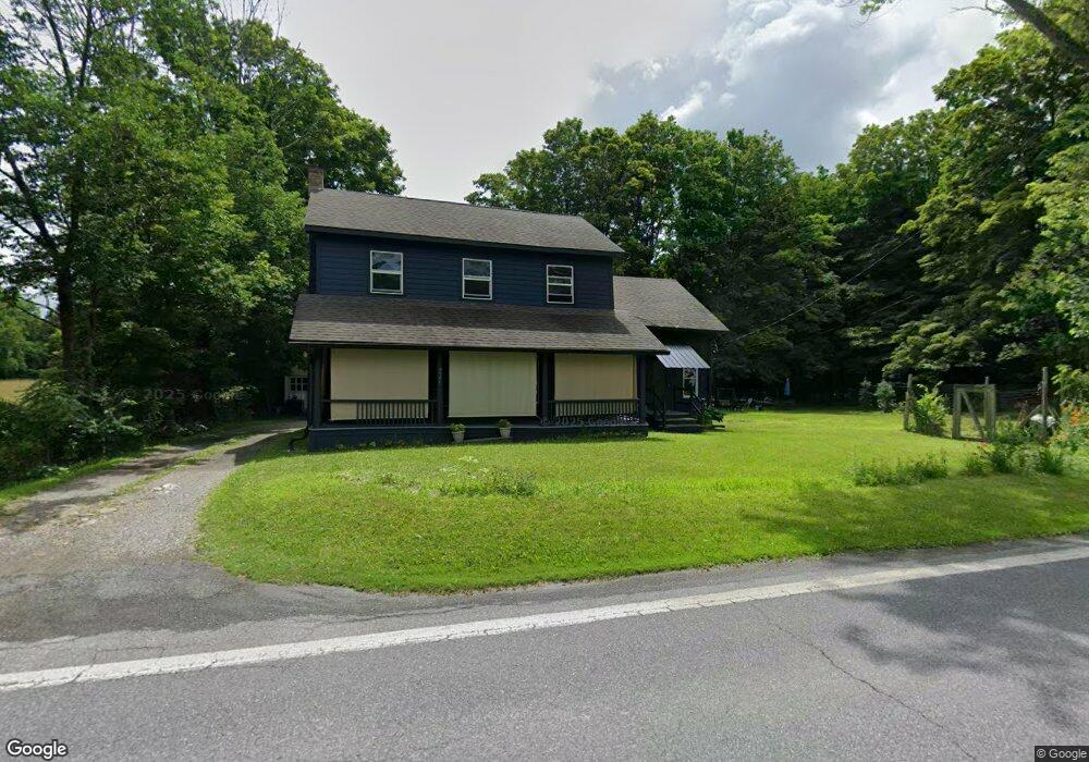
5960 Route 82 Stanfordville, NY 12581
Stanford NeighborhoodEstimated Value: $320,000 - $519,000
3
Beds
2
Baths
2,640
Sq Ft
$163/Sq Ft
Est. Value
About This Home
This home is located at 5960 Route 82, Stanfordville, NY 12581 and is currently estimated at $430,417, approximately $163 per square foot. 5960 Route 82 is a home located in Dutchess County with nearby schools including Stissing Mountain High School.
Ownership History
Date
Name
Owned For
Owner Type
Purchase Details
Closed on
Mar 5, 2010
Sold by
Mason Sari
Bought by
Schmidt Lacie
Current Estimated Value
Purchase Details
Closed on
Nov 26, 2002
Sold by
Kamen Blossom
Bought by
Mason Sari
Purchase Details
Closed on
Dec 7, 2001
Sold by
Miner Henry C
Bought by
Kammen Blossom
Purchase Details
Closed on
Mar 9, 2001
Purchase Details
Closed on
Jan 30, 2001
Sold by
Guardian Brooks Janet E
Bought by
Miner Iii Henry C Cathalin P
Create a Home Valuation Report for This Property
The Home Valuation Report is an in-depth analysis detailing your home's value as well as a comparison with similar homes in the area
Home Values in the Area
Average Home Value in this Area
Purchase History
| Date | Buyer | Sale Price | Title Company |
|---|---|---|---|
| Schmidt Lacie | $183,000 | -- | |
| Mason Sari | $192,500 | Albert Roberts | |
| Kammen Blossom | $141,000 | Bradley B Davis | |
| -- | -- | -- | |
| Miner Iii Henry C Cathalin P | $60,000 | Richard Corbally |
Source: Public Records
Tax History Compared to Growth
Tax History
| Year | Tax Paid | Tax Assessment Tax Assessment Total Assessment is a certain percentage of the fair market value that is determined by local assessors to be the total taxable value of land and additions on the property. | Land | Improvement |
|---|---|---|---|---|
| 2024 | $4,953 | $342,200 | $51,300 | $290,900 |
| 2023 | $4,879 | $329,000 | $51,300 | $277,700 |
| 2022 | $4,649 | $292,900 | $47,500 | $245,400 |
| 2021 | $4,462 | $242,600 | $44,000 | $198,600 |
| 2020 | $4,163 | $233,100 | $44,000 | $189,100 |
| 2019 | $4,186 | $233,100 | $44,000 | $189,100 |
| 2018 | $4,520 | $240,300 | $44,000 | $196,300 |
| 2017 | $4,405 | $233,700 | $44,000 | $189,700 |
| 2016 | $4,409 | $136,188 | $16,085 | $120,103 |
| 2015 | -- | $136,188 | $16,085 | $120,103 |
| 2014 | -- | $136,188 | $16,085 | $120,103 |
Source: Public Records
Map
Nearby Homes
- 5-15 Old Depot Way
- 6099 New York 82
- 2 Hunns Lake Rd
- 135 Sisters Hill Rd
- 22 Hunns Lake Rd
- 0 New York 82
- 0 New York 82
- 5760 Route 82
- 966 S Anson Rd
- 62 Ernest Rd
- 36 Market Ln
- 900 S Anson Rd
- 5654 Route 82
- 5646 Route 82
- 151 Ernest Rd
- 62 Hicks Ln
- 129 W Meadow Ln
- 287 Hunns Lake Rd
- 29 Drake Rd
- 65 Patricia Ln
- 5960 New York 82
- 2256 Bulls Head Rd
- 5957 Route 82
- 5951 Route 82
- 1 Church Ln Unit 2D
- 5967 Route 82
- 2252 Bulls Head Rd
- 5 Church Ln
- 2248 Bulls Head Rd
- 2253 Bulls Head Rd
- 2245 Bulls Head Rd
- 5979 Route 82
- 5979 Route 82 Unit 3C
- 5979 Route 82 Unit 2
- 5979 Route 82 Unit 1
- 15 Church Ln Unit COT
- 15 Church Ln Unit 2C
- 15 Church Ln Unit 1B
- 15 Church Ln Unit Cottg
- 17 Church Ln Unit D