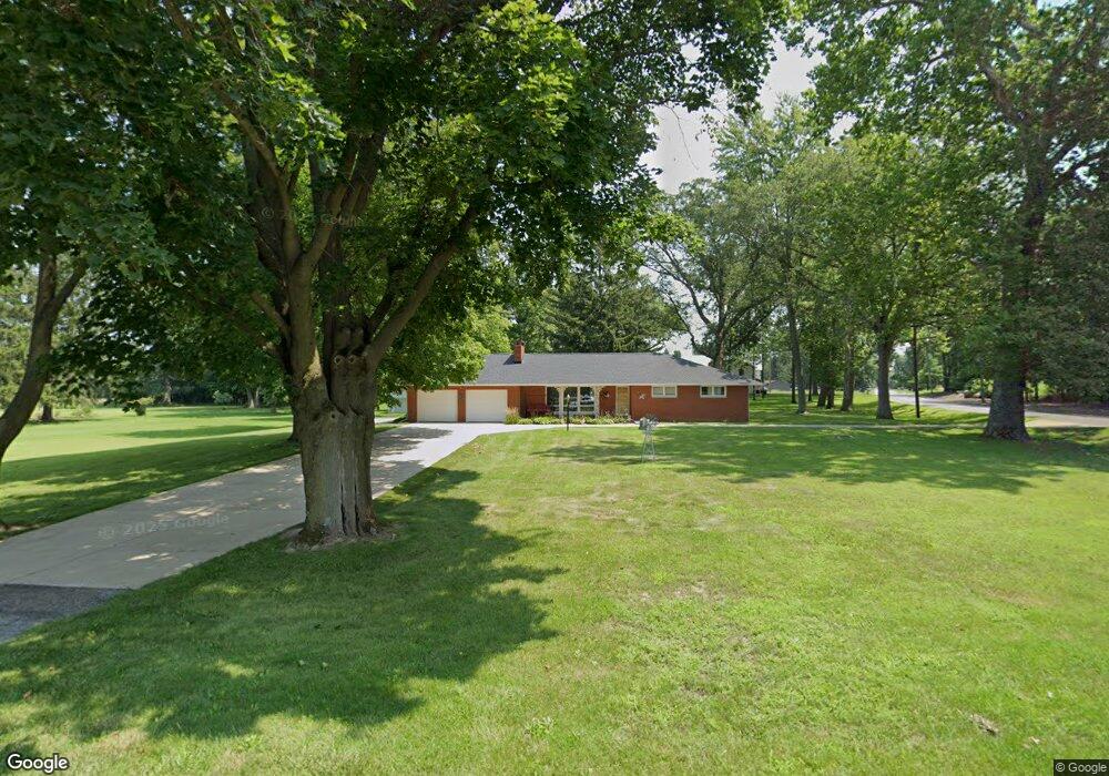
59600 Blackberry Rd Mishawaka, IN 46544
Estimated Value: $220,000 - $375,000
3
Beds
2
Baths
1,800
Sq Ft
$148/Sq Ft
Est. Value
About This Home
This home is located at 59600 Blackberry Rd, Mishawaka, IN 46544 and is currently estimated at $266,417, approximately $148 per square foot. 59600 Blackberry Rd is a home located in St. Joseph County with nearby schools including Elm Road Elementary School, Virgil I. Grissom Middle School, and Penn High School.
Ownership History
Date
Name
Owned For
Owner Type
Purchase Details
Closed on
May 28, 2010
Sold by
Miller James A and Miller Michael D
Bought by
Sherman Dennis R and Sleman Teresa L
Current Estimated Value
Home Financials for this Owner
Home Financials are based on the most recent Mortgage that was taken out on this home.
Original Mortgage
$144,000
Outstanding Balance
$97,264
Interest Rate
5.13%
Mortgage Type
New Conventional
Estimated Equity
$169,153
Purchase Details
Closed on
Jun 7, 2006
Sold by
Miller James A
Bought by
Miller Michael D and Mcbride Marcia A
Create a Home Valuation Report for This Property
The Home Valuation Report is an in-depth analysis detailing your home's value as well as a comparison with similar homes in the area
Home Values in the Area
Average Home Value in this Area
Purchase History
| Date | Buyer | Sale Price | Title Company |
|---|---|---|---|
| Sherman Dennis R | -- | Metropolitan Title In Llc | |
| Miller Michael D | -- | None Available |
Source: Public Records
Mortgage History
| Date | Status | Borrower | Loan Amount |
|---|---|---|---|
| Open | Sherman Dennis R | $144,000 |
Source: Public Records
Tax History Compared to Growth
Tax History
| Year | Tax Paid | Tax Assessment Tax Assessment Total Assessment is a certain percentage of the fair market value that is determined by local assessors to be the total taxable value of land and additions on the property. | Land | Improvement |
|---|---|---|---|---|
| 2024 | $1,194 | $154,100 | $18,600 | $135,500 |
| 2023 | $1,136 | $154,100 | $18,600 | $135,500 |
| 2022 | $1,295 | $154,200 | $18,600 | $135,600 |
| 2021 | $1,249 | $142,500 | $18,600 | $123,900 |
| 2020 | $887 | $111,500 | $18,600 | $92,900 |
| 2019 | $943 | $113,900 | $20,900 | $93,000 |
| 2018 | $920 | $115,000 | $20,900 | $94,100 |
| 2017 | $926 | $113,000 | $20,900 | $92,100 |
| 2016 | $938 | $113,100 | $20,900 | $92,200 |
| 2014 | $944 | $111,000 | $20,900 | $90,100 |
Source: Public Records
Map
Nearby Homes
- 1725 Stoneham
- Lot 619A Stoneham Unit 619
- Lot 683A Stoneham Unit 683
- 1602 Stoneham
- VL Blackberry Rd
- Lot 677A Rosemont Place Unit 677A
- Lot 607A Rosemont Place Unit 607A
- Lot 608A Rosemont Place Unit 608A
- 1568 Blanchard Dr
- 4020 Stonegate Dr
- 3964 Stonegate Dr
- 3811 Dudley Dr
- Lot 682A Stoneham Dr Unit 682A
- Lot 681A Stoneham Dr Unit 681A
- 1556 Conant Ct
- 1529 Hampton Ct
- 3421 Westborough Dr
- 14251 Dragoon Trail
- 1119 Warrington Ct
- 1101 Wellsley Ct
- 59552 Blackberry Rd
- 12768 Dragoon Trail
- 12685 Dragoon Trail
- 12844 Dragoon Trail
- 12674 Dragoon Trail
- 12675 Dragoon Trail
- 12862 Dragoon Trail
- 12633 Dragoon Trail
- 12882 Dragoon Trail
- 12906 Dragoon Trail
- 12599 Dragoon Trail
- 59679 Tyholland Ln
- 59701 Tyholland Ln
- 12960 Dragoon Trail
- 59727 Tyholland Ln
- VL Lot #7 59785 Tyholland Ln Unit 7
- VL Lot #7 Tyholland Ln Unit 7
- 59736 Tyholland Ln
- 59741 Tyholland Ln
- 59777 Tyholland Ln