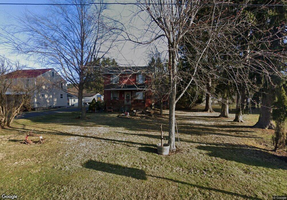
597 Coal Hill Rd Clearfield, PA 16830
Estimated Value: $87,856 - $166,000
--
Bed
--
Bath
--
Sq Ft
8,015
Sq Ft Lot
About This Home
This home is located at 597 Coal Hill Rd, Clearfield, PA 16830 and is currently estimated at $126,464. 597 Coal Hill Rd is a home located in Clearfield County with nearby schools including Clearfield Area Junior-Senior High School and Clearfield Alliance Christian School.
Ownership History
Date
Name
Owned For
Owner Type
Purchase Details
Closed on
May 14, 2013
Sold by
Meyers Jamey Earl and Meyers Tracy Lynn
Bought by
Marsh Lisa L and Oswalt Michael L
Current Estimated Value
Home Financials for this Owner
Home Financials are based on the most recent Mortgage that was taken out on this home.
Original Mortgage
$77,806
Outstanding Balance
$55,060
Interest Rate
3.45%
Mortgage Type
New Conventional
Estimated Equity
$71,404
Purchase Details
Closed on
Jul 3, 2008
Sold by
Benway Randy
Bought by
Meyers Jamey Earl and Meyers Tracy Lynn
Create a Home Valuation Report for This Property
The Home Valuation Report is an in-depth analysis detailing your home's value as well as a comparison with similar homes in the area
Home Values in the Area
Average Home Value in this Area
Purchase History
| Date | Buyer | Sale Price | Title Company |
|---|---|---|---|
| Marsh Lisa L | $76,250 | None Available | |
| Meyers Jamey Earl | $37,950 | None Available |
Source: Public Records
Mortgage History
| Date | Status | Borrower | Loan Amount |
|---|---|---|---|
| Open | Marsh Lisa L | $77,806 |
Source: Public Records
Tax History Compared to Growth
Tax History
| Year | Tax Paid | Tax Assessment Tax Assessment Total Assessment is a certain percentage of the fair market value that is determined by local assessors to be the total taxable value of land and additions on the property. | Land | Improvement |
|---|---|---|---|---|
| 2025 | $1,070 | $13,900 | $3,500 | $10,400 |
| 2024 | $174 | $6,950 | $1,750 | $5,200 |
| 2023 | $1,029 | $6,950 | $1,750 | $5,200 |
| 2022 | $1,030 | $7,150 | $1,750 | $5,400 |
| 2021 | $1,030 | $7,150 | $1,750 | $5,400 |
| 2020 | $1,030 | $7,150 | $1,750 | $5,400 |
| 2019 | $1,008 | $7,150 | $1,750 | $5,400 |
| 2018 | $946 | $7,150 | $1,750 | $5,400 |
| 2017 | $971 | $7,150 | $1,750 | $5,400 |
| 2016 | -- | $7,150 | $1,750 | $5,400 |
| 2015 | -- | $6,600 | $1,750 | $4,850 |
| 2014 | -- | $6,600 | $1,750 | $4,850 |
Source: Public Records
Map
Nearby Homes
- 41 Danvir Rd
- 617 Arrowhead Way
- 1309 Powell Ave
- 5315 Bigler Rd
- 1220 Lawhead St
- 1404 Powell Ave
- 5101 Bigler Rd
- 0 Williams Rd
- 708 Nichols St
- 1126 Sycamore Ln
- 332 W 5th St
- 525 S 3rd St
- 2050 Legion Rd
- 317 Turnpike Ave
- 0 Martin St Extension
- 0 Turnpike Ave
- 525 Martin St
- 514 Turnpike Ave
- 0 Chester and Cumberland St
- 222 Clearfield St
- 585 Coal Hill Rd
- 619 Coal Hill Rd
- 573 Coal Hill Rd
- 559 Coal Hill Rd
- 616 Fletcher Rd
- 617 Armor St
- 614 Fletcher Rd
- 543 Coal Hill Rd
- 628 Armor St
- 535 Coal Hill Rd
- 663 Coal Hill Rd
- 618 Armor St
- 677 Coal Hill Rd
- 619 Fletcher Rd
- 616 Armor St
- 617 Fletcher Rd
- 521 Coal Hill Rd
- 689 Coal Hill Rd
- 614 Armor St
- 615 Fletcher Rd