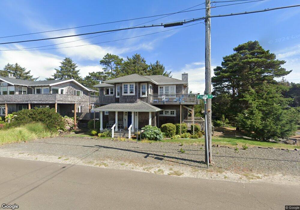
597 N Marion Ave Seaside, OR 97138
Estimated Value: $1,016,672 - $1,423,000
2
Beds
3
Baths
1,874
Sq Ft
$631/Sq Ft
Est. Value
About This Home
This home is located at 597 N Marion Ave, Seaside, OR 97138 and is currently estimated at $1,183,168, approximately $631 per square foot. 597 N Marion Ave is a home located in Clatsop County with nearby schools including Seaside High School.
Ownership History
Date
Name
Owned For
Owner Type
Purchase Details
Closed on
Mar 4, 2021
Sold by
Starr Philip
Bought by
Starr Philip James and Philip James Starr Liv Tr
Current Estimated Value
Purchase Details
Closed on
Jul 28, 2017
Sold by
Moseley David H and Moseley Fennessy J
Bought by
Starr Philip
Home Financials for this Owner
Home Financials are based on the most recent Mortgage that was taken out on this home.
Original Mortgage
$492,000
Outstanding Balance
$262,677
Interest Rate
3.91%
Mortgage Type
Closed End Mortgage
Estimated Equity
$920,491
Create a Home Valuation Report for This Property
The Home Valuation Report is an in-depth analysis detailing your home's value as well as a comparison with similar homes in the area
Home Values in the Area
Average Home Value in this Area
Purchase History
| Date | Buyer | Sale Price | Title Company |
|---|---|---|---|
| Starr Philip James | -- | None Available | |
| Starr Philip | $615,000 | Ticor Title Company Of Or |
Source: Public Records
Mortgage History
| Date | Status | Borrower | Loan Amount |
|---|---|---|---|
| Open | Starr Philip | $492,000 |
Source: Public Records
Tax History Compared to Growth
Tax History
| Year | Tax Paid | Tax Assessment Tax Assessment Total Assessment is a certain percentage of the fair market value that is determined by local assessors to be the total taxable value of land and additions on the property. | Land | Improvement |
|---|---|---|---|---|
| 2024 | $6,600 | $577,048 | -- | -- |
| 2023 | $6,250 | $545,876 | $0 | $0 |
| 2022 | $6,063 | $529,977 | $0 | $0 |
| 2021 | $6,189 | $514,542 | $0 | $0 |
| 2020 | $5,970 | $499,556 | $0 | $0 |
| 2019 | $5,816 | $485,007 | $0 | $0 |
| 2018 | $5,606 | $470,882 | $0 | $0 |
| 2017 | $5,458 | $457,168 | $0 | $0 |
| 2016 | $4,714 | $443,853 | $169,573 | $274,280 |
| 2015 | $4,559 | $430,926 | $164,634 | $266,292 |
| 2014 | $4,334 | $418,375 | $0 | $0 |
| 2013 | -- | $406,190 | $0 | $0 |
Source: Public Records
Map
Nearby Homes
- 1396 N Ocean Ave
- 766 Neacoxie Blvd
- 856 Neacoxie Blvd
- 856 Neacoxie Blvd Unit 311
- 101 13th St Unit 209
- Lots 25-26 5th St
- 714 7th St
- 1238 N Marion Ave Unit 467
- 1238 N Marion Ave Unit 470
- 1238 N Marion Ave
- 1238 N Marion Pacific View Condo Ave Unit 467
- 0 5th St
- 1398 N Ocean Ave
- 1400 N Ocean Ave
- 1054 Picture Place
- 1065 Picture Place
- 196 Dylan Ct
- 645 Meadow Ln
- 1265 D St
- 639 N Marion Ave
- 537 Marion Ave
- 599 S Marion Ave
- 598 S Marion Ave
- 567 Marion Ave
- 674 N Marion Ave Unit 3-674
- 678 N Marion Ave Unit 1
- 647 N Marion Ave
- 538 S Marion Ave
- 657 S Marion Ave
- 507 Marion Ave
- 265 6th Ave
- 666 S Marion Ave
- 266 6th Ave
- 0 N Marion Ave Unit 3-660 181032
- 0 N Marion Ave Unit 506 47460
- 0 N Marion Ave Unit 23-579
- 0 N Marion Ave Unit 23495193
- 0 N Marion Ave Unit 12-928
- 0 N Marion Ave Unit 22085424