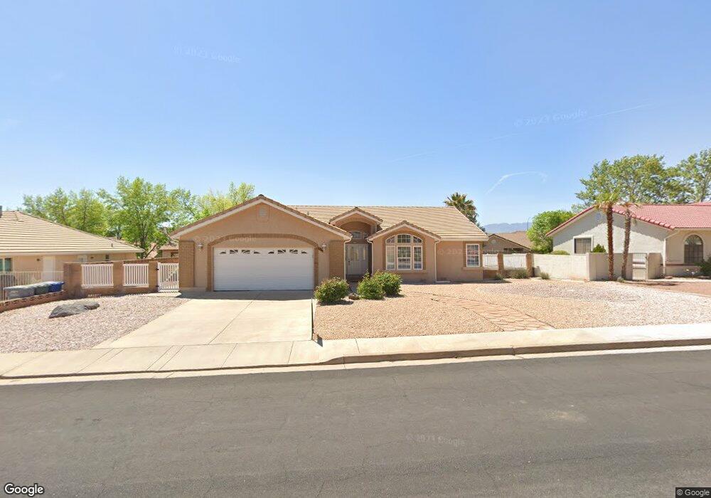
597 N Northstar Saint George, UT 84770
Estimated Value: $449,000 - $484,000
3
Beds
2
Baths
1,800
Sq Ft
$258/Sq Ft
Est. Value
About This Home
This home is located at 597 N Northstar, Saint George, UT 84770 and is currently estimated at $465,117, approximately $258 per square foot. 597 N Northstar is a home located in Washington County with nearby schools including Sunset School, Snow Canyon Middle School, and Lava Ridge Intermediate School.
Ownership History
Date
Name
Owned For
Owner Type
Purchase Details
Closed on
May 15, 2023
Sold by
Sundin David Ray
Bought by
Campbell Hunter Eric and Campbell Abby Alayne
Current Estimated Value
Home Financials for this Owner
Home Financials are based on the most recent Mortgage that was taken out on this home.
Original Mortgage
$366,400
Outstanding Balance
$355,987
Interest Rate
6.27%
Mortgage Type
New Conventional
Estimated Equity
$109,130
Purchase Details
Closed on
Nov 20, 2018
Sold by
Sundin David Ray and Sundin Diann A
Bought by
Sundin David Ray and Sundin Diann
Home Financials for this Owner
Home Financials are based on the most recent Mortgage that was taken out on this home.
Original Mortgage
$265,574
Interest Rate
4.9%
Mortgage Type
VA
Purchase Details
Closed on
Jul 19, 2007
Sold by
Mckasson Hila L
Bought by
Sundin David Ray and Sundin Diann A
Create a Home Valuation Report for This Property
The Home Valuation Report is an in-depth analysis detailing your home's value as well as a comparison with similar homes in the area
Home Values in the Area
Average Home Value in this Area
Purchase History
| Date | Buyer | Sale Price | Title Company |
|---|---|---|---|
| Campbell Hunter Eric | -- | Southern Utah Title Company | |
| Sundin David Ray | -- | Mountain View Title | |
| Sundin David Ray | -- | Terra Title Co |
Source: Public Records
Mortgage History
| Date | Status | Borrower | Loan Amount |
|---|---|---|---|
| Open | Campbell Hunter Eric | $366,400 | |
| Previous Owner | Sundin David Ray | $265,574 |
Source: Public Records
Tax History Compared to Growth
Tax History
| Year | Tax Paid | Tax Assessment Tax Assessment Total Assessment is a certain percentage of the fair market value that is determined by local assessors to be the total taxable value of land and additions on the property. | Land | Improvement |
|---|---|---|---|---|
| 2025 | $1,594 | $237,710 | $74,250 | $163,460 |
| 2023 | $1,596 | $238,425 | $74,250 | $164,175 |
| 2022 | $1,738 | $244,200 | $68,750 | $175,450 |
| 2021 | $1,541 | $322,800 | $75,000 | $247,800 |
| 2020 | $1,334 | $263,300 | $70,000 | $193,300 |
| 2019 | $1,394 | $268,700 | $55,000 | $213,700 |
| 2018 | $1,286 | $124,245 | $0 | $0 |
| 2017 | $1,229 | $118,745 | $0 | $0 |
| 2016 | $1,207 | $107,910 | $0 | $0 |
| 2015 | $1,170 | $100,320 | $0 | $0 |
| 2014 | $1,201 | $103,675 | $0 | $0 |
Source: Public Records
Map
Nearby Homes
- 565 N Moonglow Place
- 1950 W 470 St N
- 414 Northstar Dr
- 1732 W 540 N Unit 13
- 1732 W 540 N Unit 120
- 1732 W 540 N Unit 92
- 1732 W 540 N Unit 161
- 1732 W 540 N Unit 68
- 1732 W 540 N Unit 17
- 765 Country Place Ct
- 340 N Country Ln Unit 66
- 340 N Country Ln Unit 27
- 271 N Country Ln Unit 60
- 271 N Country Ln Unit B14
- 1735 W 540 N Unit 1203
- 1735 W 540 N Unit 1202
- 2394 W Chardonnay
- 2393 W Zinfandel Dr
- 225 N Country Ln Unit 111
- 225 N Country Ln Unit 104
- 597 Northstar Dr
- 611 N Northstar Dr
- 611 Northstar Dr
- 575 Northstar Dr
- 584 N Moonglow Place
- 2042 W Moonglow Place
- 602 N Moonglow Place
- 590 Northstar Dr
- 614 N Northstar Dr
- 614 Northstar Dr
- 2060 W Moonglow Place
- 623 Northstar Dr
- 0 Northstar Dr
- 5143 Northstar Dr
- 115 Northstar Dr Unit 115
- 592 Northstar Dr
- 572 N Northstar Dr
- 618 N Moonglow Place
- 628 Northstar Dr
- 628 N Northstar Dr