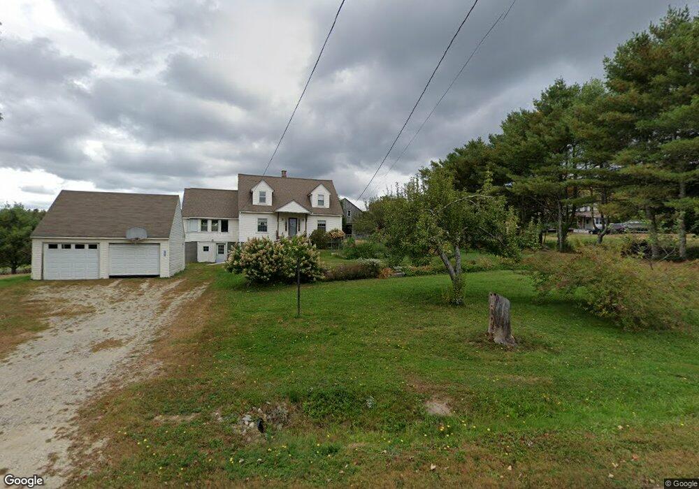
598 W Burrough Rd Bowdoin, ME 04287
Estimated Value: $378,000 - $401,000
5
Beds
2
Baths
1,568
Sq Ft
$251/Sq Ft
Est. Value
About This Home
This home is located at 598 W Burrough Rd, Bowdoin, ME 04287 and is currently estimated at $393,330, approximately $250 per square foot. 598 W Burrough Rd is a home with nearby schools including Mt Ararat High School.
Ownership History
Date
Name
Owned For
Owner Type
Purchase Details
Closed on
Jan 11, 2021
Sold by
Gauthier Stephanie E
Bought by
Gauthier Bethany F and Gauthier Stephanie E
Current Estimated Value
Home Financials for this Owner
Home Financials are based on the most recent Mortgage that was taken out on this home.
Original Mortgage
$117,000
Outstanding Balance
$103,944
Interest Rate
2.71%
Mortgage Type
Purchase Money Mortgage
Estimated Equity
$289,386
Create a Home Valuation Report for This Property
The Home Valuation Report is an in-depth analysis detailing your home's value as well as a comparison with similar homes in the area
Home Values in the Area
Average Home Value in this Area
Purchase History
| Date | Buyer | Sale Price | Title Company |
|---|---|---|---|
| Gauthier Bethany F | -- | None Available | |
| Gauthier Stephanie E | -- | None Available | |
| Gauthier Bethany F | -- | None Available | |
| Gauthier Stephanie E | -- | None Available |
Source: Public Records
Mortgage History
| Date | Status | Borrower | Loan Amount |
|---|---|---|---|
| Open | Gauthier Bethany F | $117,000 | |
| Closed | Gauthier Bethany F | $117,000 |
Source: Public Records
Tax History Compared to Growth
Tax History
| Year | Tax Paid | Tax Assessment Tax Assessment Total Assessment is a certain percentage of the fair market value that is determined by local assessors to be the total taxable value of land and additions on the property. | Land | Improvement |
|---|---|---|---|---|
| 2025 | $4,061 | $381,300 | $92,200 | $289,100 |
| 2024 | $3,699 | $381,300 | $92,200 | $289,100 |
| 2023 | $2,799 | $153,800 | $49,200 | $104,600 |
| 2022 | $2,725 | $161,220 | $49,180 | $112,040 |
| 2021 | $2,800 | $168,670 | $49,180 | $119,490 |
| 2020 | $2,699 | $168,670 | $49,180 | $119,490 |
| 2019 | $2,665 | $168,670 | $49,180 | $119,490 |
| 2018 | $2,547 | $168,670 | $49,180 | $119,490 |
| 2017 | $2,530 | $168,670 | $49,180 | $119,490 |
| 2016 | $2,479 | $168,670 | $49,180 | $119,490 |
| 2015 | $2,463 | $168,670 | $49,180 | $119,490 |
| 2014 | $2,345 | $168,670 | $49,180 | $119,490 |
| 2013 | $2,193 | $168,670 | $49,180 | $119,490 |
Source: Public Records
Map
Nearby Homes
- 608 W Burrough Rd
- 596 W Burrough Rd
- 597 W Burrough Rd
- 595 W Burrough Rd
- 578 W Burrough Rd
- 621 W Burrough Rd
- 631 W Burrough Rd
- 547 W Burrough Rd
- 546 W Burrough Rd
- 0 W Burrough Rd
- 668 W Burrough Rd
- 526 W Burrough Rd
- 645 W Burrough Rd
- 513 W Burrough Rd
- 26 Denham Ln
- 504 W Burrough Rd
- 496 W Burrough Rd
- 479 W Burrough Rd
- 469 W Burrough Rd
- 462 W Burrough Rd