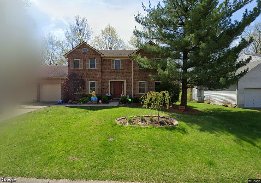
5986 Woods Bend Dr Milford, OH 45150
Estimated Value: $419,940 - $470,000
4
Beds
3
Baths
2,165
Sq Ft
$203/Sq Ft
Est. Value
About This Home
This home is located at 5986 Woods Bend Dr, Milford, OH 45150 and is currently estimated at $440,235, approximately $203 per square foot. 5986 Woods Bend Dr is a home located in Clermont County with nearby schools including Milford Senior High School, St. Andrew - St. Elizabeth Ann Seton School, and St. Mark's Lutheran School.
Ownership History
Date
Name
Owned For
Owner Type
Purchase Details
Closed on
Mar 9, 2000
Sold by
Collins Edward J
Bought by
Moore Steven L and Moore Pamela J
Current Estimated Value
Home Financials for this Owner
Home Financials are based on the most recent Mortgage that was taken out on this home.
Original Mortgage
$163,400
Outstanding Balance
$55,258
Interest Rate
8.26%
Mortgage Type
New Conventional
Estimated Equity
$384,977
Purchase Details
Closed on
Apr 27, 1993
Create a Home Valuation Report for This Property
The Home Valuation Report is an in-depth analysis detailing your home's value as well as a comparison with similar homes in the area
Home Values in the Area
Average Home Value in this Area
Purchase History
| Date | Buyer | Sale Price | Title Company |
|---|---|---|---|
| Moore Steven L | $172,000 | -- | |
| -- | $141,500 | -- |
Source: Public Records
Mortgage History
| Date | Status | Borrower | Loan Amount |
|---|---|---|---|
| Open | Moore Steven L | $163,400 |
Source: Public Records
Tax History Compared to Growth
Tax History
| Year | Tax Paid | Tax Assessment Tax Assessment Total Assessment is a certain percentage of the fair market value that is determined by local assessors to be the total taxable value of land and additions on the property. | Land | Improvement |
|---|---|---|---|---|
| 2024 | $4,624 | $99,510 | $16,310 | $83,200 |
| 2023 | $4,671 | $99,510 | $16,310 | $83,200 |
| 2022 | $4,351 | $70,560 | $11,550 | $59,010 |
| 2021 | $4,348 | $70,560 | $11,550 | $59,010 |
| 2020 | $4,170 | $70,560 | $11,550 | $59,010 |
| 2019 | $4,563 | $73,360 | $11,550 | $61,810 |
| 2018 | $4,564 | $73,360 | $11,550 | $61,810 |
| 2017 | $4,180 | $73,360 | $11,550 | $61,810 |
| 2016 | $4,260 | $62,200 | $9,800 | $52,400 |
| 2015 | $3,899 | $62,200 | $9,800 | $52,400 |
| 2014 | $3,899 | $62,200 | $9,800 | $52,400 |
| 2013 | $3,745 | $57,930 | $10,500 | $47,430 |
Source: Public Records
Map
Nearby Homes
- 957 Tarragon Ln
- 5612 Flagstone Way
- 5884 Stonebridge Cir
- 5897 Cook Rd
- 5880 Stonebridge Cir
- 977 Newberry Ave
- 1010 Newberry Ave
- 772 Price Knoll Ln
- 1706 Cottontail Dr
- 1007 Valley View Dr
- 1093 Broadview Place
- 1139 Willowwood Dr
- 5702 Sherwood Dr
- 2403 Traverse Creek Dr
- 6211 Cook Rd
- 732 St Rt 28
- 1113 Clover Field Dr
- 1124 Clover Field Dr
- 1201 Sorrel Ln
- 6141 Brandywine Ct
- 5988 Woodsbend Dr
- 5988 Woods Bend Dr
- 5984 Woods Bend Dr
- 5990 Woods Bend Dr
- 5982 Woods Bend Dr
- 5989 Woodsbend Dr
- 5991 Woodsbend Dr
- 5989 Woods Bend Dr
- 5991 Woods Bend Dr
- 5993 Woodsbend Dr
- 5987 Woodsbend Dr
- 5987 Woods Bend Dr
- 5993 Woods Bend Dr
- 5980 Woods Bend Dr
- 5985 Woods Bend Dr
- 5995 Woods Bend Dr
- 5978 Woodsbend Dr
- 5978 Woods Bend Dr
- 5997 Woods Bend Dr
- 6215 Watchcreek Way