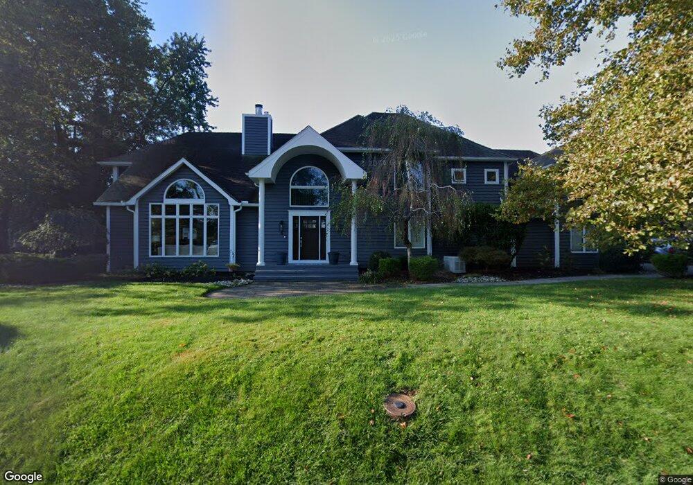
6 Algonquin Ave Oceanport, NJ 07757
Estimated Value: $1,449,000 - $1,729,656
6
Beds
1
Bath
4,148
Sq Ft
$388/Sq Ft
Est. Value
About This Home
This home is located at 6 Algonquin Ave, Oceanport, NJ 07757 and is currently estimated at $1,608,664, approximately $387 per square foot. 6 Algonquin Ave is a home located in Monmouth County with nearby schools including Wolf Hill Elementary School, Maple Place Elementary and Middle School, and Shore Regional High School.
Ownership History
Date
Name
Owned For
Owner Type
Purchase Details
Closed on
Sep 15, 2011
Sold by
Parker Combes William and Parker Combes Melissa
Bought by
Frame Michael and Frame Nicole
Current Estimated Value
Home Financials for this Owner
Home Financials are based on the most recent Mortgage that was taken out on this home.
Original Mortgage
$537,600
Outstanding Balance
$370,249
Interest Rate
4.38%
Mortgage Type
Stand Alone First
Estimated Equity
$1,238,415
Purchase Details
Closed on
Feb 8, 1996
Sold by
Smith Steven
Bought by
Smith Philip and Smith Marsha
Home Financials for this Owner
Home Financials are based on the most recent Mortgage that was taken out on this home.
Original Mortgage
$260,000
Interest Rate
6.99%
Create a Home Valuation Report for This Property
The Home Valuation Report is an in-depth analysis detailing your home's value as well as a comparison with similar homes in the area
Home Values in the Area
Average Home Value in this Area
Purchase History
| Date | Buyer | Sale Price | Title Company |
|---|---|---|---|
| Frame Michael | $672,000 | None Available | |
| Smith Philip | $360,000 | -- |
Source: Public Records
Mortgage History
| Date | Status | Borrower | Loan Amount |
|---|---|---|---|
| Open | Frame Michael | $537,600 | |
| Previous Owner | Smith Philip | $260,000 |
Source: Public Records
Tax History Compared to Growth
Tax History
| Year | Tax Paid | Tax Assessment Tax Assessment Total Assessment is a certain percentage of the fair market value that is determined by local assessors to be the total taxable value of land and additions on the property. | Land | Improvement |
|---|---|---|---|---|
| 2025 | $17,568 | $1,126,200 | $411,000 | $715,200 |
| 2024 | $17,740 | $1,112,600 | $373,000 | $739,600 |
| 2023 | $17,740 | $1,066,100 | $363,500 | $702,600 |
| 2022 | $17,497 | $953,600 | $335,000 | $618,600 |
| 2021 | $17,497 | $918,500 | $330,200 | $588,300 |
| 2020 | $16,520 | $903,700 | $325,500 | $578,200 |
| 2019 | $15,914 | $883,600 | $325,500 | $558,100 |
| 2018 | $15,686 | $876,800 | $342,600 | $534,200 |
| 2017 | $13,410 | $621,700 | $193,000 | $428,700 |
| 2016 | $13,169 | $614,500 | $194,000 | $420,500 |
| 2015 | $12,417 | $598,700 | $189,000 | $409,700 |
| 2014 | $12,896 | $630,600 | $239,000 | $391,600 |
Source: Public Records
Map
Nearby Homes
- 580 Patten Ave Unit 47
- 580 Patten Ave Unit 48
- 580 Patten Ave Unit 62
- 580 Patten Ave Unit 86
- 15 Signal Ave
- 27 Ithaca Ave
- 13 Bayview Ct
- 177 Kingsley St
- 16 Shore Dr
- 165 Kingsley St
- 164 Airsdale Ave
- 392 Florence Ave
- 165 Riddle Ave Unit 7
- 24 Baruch Dr
- 13 Morris Place
- 154 Atlantic Ave
- 323 Florence Ave
- 3 Foggia Way
- 1 Foggia Way
- 8 Mann Ct
- 7 Hiawatha Ave
- 118 Comanche Dr
- 128 Comanche Dr
- 11 Hiawatha Ave
- 12 Algonquin Ave
- 125 Comanche Dr
- 9 Algonquin Ave
- 127 Comanche Dr
- 123 Comanche Dr
- 6 Hiawatha Ave
- 134 Comanche Dr
- 10 Hiawatha Ave
- 2 Hiawatha Ave
- 117 Comanche Dr
- 133 Comanche Dr
- 15 Algonquin Ave
- 16 Algonquin Ave
- 19 Hiawatha Ave
- 12 Wyandotte Ave
- 14 Hiawatha Ave