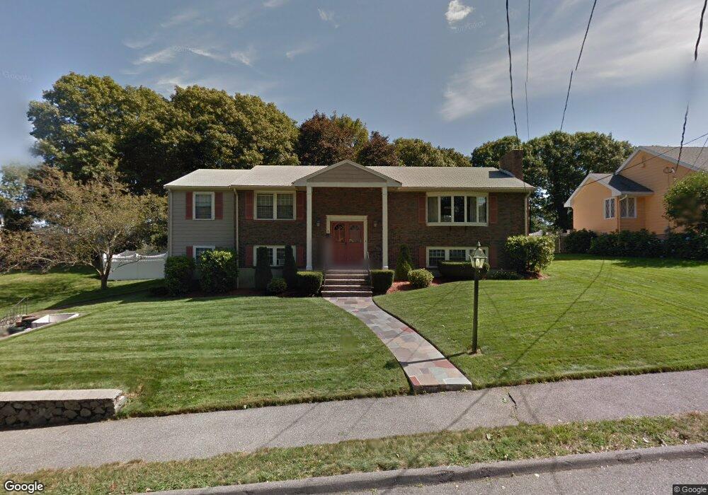
6 Arthur Rd Wakefield, MA 01880
Greenwood NeighborhoodEstimated Value: $1,037,000 - $1,343,000
4
Beds
3
Baths
3,146
Sq Ft
$358/Sq Ft
Est. Value
About This Home
This home is located at 6 Arthur Rd, Wakefield, MA 01880 and is currently estimated at $1,127,756, approximately $358 per square foot. 6 Arthur Rd is a home located in Middlesex County with nearby schools including Wakefield Memorial High School and Melrose Montessori School.
Ownership History
Date
Name
Owned For
Owner Type
Purchase Details
Closed on
Dec 23, 2019
Sold by
Lomasney John D and Lomasney Virginia H
Bought by
Lomasney Virginia H
Current Estimated Value
Home Financials for this Owner
Home Financials are based on the most recent Mortgage that was taken out on this home.
Original Mortgage
$285,000
Outstanding Balance
$249,091
Interest Rate
3.6%
Mortgage Type
New Conventional
Estimated Equity
$878,665
Purchase Details
Closed on
Jul 14, 2000
Sold by
Calareso Ronald W and Calareso Patricia A
Bought by
Lomasney John D and Lomasney Virginia H
Home Financials for this Owner
Home Financials are based on the most recent Mortgage that was taken out on this home.
Original Mortgage
$252,700
Interest Rate
8.5%
Mortgage Type
Purchase Money Mortgage
Create a Home Valuation Report for This Property
The Home Valuation Report is an in-depth analysis detailing your home's value as well as a comparison with similar homes in the area
Home Values in the Area
Average Home Value in this Area
Purchase History
| Date | Buyer | Sale Price | Title Company |
|---|---|---|---|
| Lomasney Virginia H | -- | None Available | |
| Lomasney John D | $419,900 | -- |
Source: Public Records
Mortgage History
| Date | Status | Borrower | Loan Amount |
|---|---|---|---|
| Open | Lomasney Virginia H | $285,000 | |
| Previous Owner | Lomasney John D | $25,000 | |
| Previous Owner | Lomasney John D | $275,000 | |
| Previous Owner | Lomasney John D | $252,700 |
Source: Public Records
Tax History
| Year | Tax Paid | Tax Assessment Tax Assessment Total Assessment is a certain percentage of the fair market value that is determined by local assessors to be the total taxable value of land and additions on the property. | Land | Improvement |
|---|---|---|---|---|
| 2025 | $10,355 | $912,300 | $413,400 | $498,900 |
| 2024 | $9,961 | $885,400 | $401,200 | $484,200 |
| 2023 | $9,617 | $819,900 | $371,500 | $448,400 |
| 2022 | $9,183 | $745,400 | $337,700 | $407,700 |
| 2021 | $9,177 | $720,900 | $314,200 | $406,700 |
| 2020 | $8,827 | $691,200 | $301,300 | $389,900 |
| 2019 | $8,561 | $667,300 | $290,900 | $376,400 |
| 2018 | $8,102 | $625,600 | $272,700 | $352,900 |
| 2017 | $7,763 | $595,800 | $259,700 | $336,100 |
| 2016 | $7,259 | $538,100 | $240,400 | $297,700 |
| 2015 | $6,780 | $503,000 | $224,700 | $278,300 |
| 2014 | $6,229 | $487,400 | $217,700 | $269,700 |
Source: Public Records
Map
Nearby Homes
- 11 Ludlow Ave
- 12 Lovis Ave
- 9 Lovis Ave
- 33 Lake Ave
- 824 Main St Unit 1
- 601 Franklin St Unit 2
- 23 Ellsworth Ave
- 24 Ellsworth Ave
- 7 West St
- 34-36 W Highland Ave
- 9 Ledge St
- 98 Boardman Ave
- 159 Franklin St Unit D2
- 159 Franklin St Unit C2
- 159 Franklin St Unit E6
- 1 Sidney St
- 51 Spring St
- 11 Valdora Dr
- 176 Bay State Rd
- 53 Perkins St
Your Personal Tour Guide
Ask me questions while you tour the home.