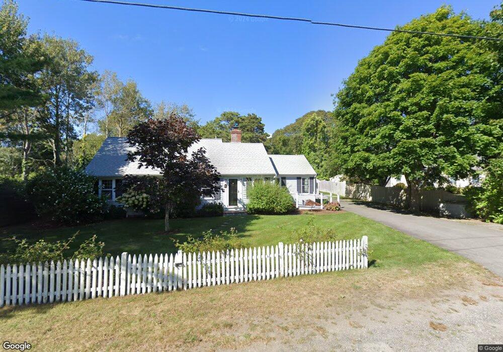
6 Brooks Ln Harwich Port, MA 02646
Northwest Harwich NeighborhoodEstimated Value: $1,021,000 - $1,460,261
2
Beds
1
Bath
1,201
Sq Ft
$1,006/Sq Ft
Est. Value
About This Home
This home is located at 6 Brooks Ln, Harwich Port, MA 02646 and is currently estimated at $1,208,065, approximately $1,005 per square foot. 6 Brooks Ln is a home located in Barnstable County with nearby schools including Harwich Elementary School, Chatham Elementary School, and Monomoy Regional Middle School.
Ownership History
Date
Name
Owned For
Owner Type
Purchase Details
Closed on
Jun 17, 2022
Sold by
Sarah M Brown Ret
Bought by
Little Cape House Llc
Current Estimated Value
Purchase Details
Closed on
Jan 20, 2005
Sold by
Brown Sarah M and Brown Stephen R
Bought by
Sarah M Brown Ret and Brown Sarah M
Purchase Details
Closed on
Sep 7, 2001
Sold by
Fowler Eileen
Bought by
Brown Stephan R and Brown Sarah M
Home Financials for this Owner
Home Financials are based on the most recent Mortgage that was taken out on this home.
Original Mortgage
$230,400
Interest Rate
7.05%
Mortgage Type
Purchase Money Mortgage
Create a Home Valuation Report for This Property
The Home Valuation Report is an in-depth analysis detailing your home's value as well as a comparison with similar homes in the area
Home Values in the Area
Average Home Value in this Area
Purchase History
| Date | Buyer | Sale Price | Title Company |
|---|---|---|---|
| Little Cape House Llc | -- | None Available | |
| Sarah M Brown Ret | -- | -- | |
| Brown Stephan R | $288,000 | -- |
Source: Public Records
Mortgage History
| Date | Status | Borrower | Loan Amount |
|---|---|---|---|
| Previous Owner | Brown Stephan R | $228,900 | |
| Previous Owner | Brown Stephan R | $230,400 |
Source: Public Records
Tax History Compared to Growth
Tax History
| Year | Tax Paid | Tax Assessment Tax Assessment Total Assessment is a certain percentage of the fair market value that is determined by local assessors to be the total taxable value of land and additions on the property. | Land | Improvement |
|---|---|---|---|---|
| 2025 | $6,477 | $1,096,000 | $403,800 | $692,200 |
| 2024 | $6,000 | $995,100 | $341,800 | $653,300 |
| 2023 | $5,453 | $821,200 | $266,400 | $554,800 |
| 2022 | $5,659 | $697,800 | $270,300 | $427,500 |
| 2021 | $5,633 | $655,000 | $245,700 | $409,300 |
| 2020 | $5,544 | $635,000 | $237,400 | $397,600 |
| 2019 | $5,153 | $594,400 | $216,200 | $378,200 |
| 2018 | $5,122 | $565,100 | $196,500 | $368,600 |
| 2017 | $4,907 | $547,100 | $189,000 | $358,100 |
| 2016 | $4,823 | $531,700 | $189,000 | $342,700 |
| 2015 | $4,647 | $518,100 | $185,300 | $332,800 |
| 2014 | $4,413 | $503,200 | $179,800 | $323,400 |
Source: Public Records
Map
Nearby Homes
- 297 Massachusetts 28
- 297 Massachusetts 28 Unit 1
- 292 Massachusetts 28 Unit 1
- 292 Massachusetts 28 Unit 7
- 16 Mirasol Ln
- 292 Route 28 Unit 7
- 264 Massachusetts 28
- 231 Roue 28 Unit 20
- 231 Route 28 Unit 20
- 231 Route 28 Unit 8
- 231 Route 28 Unit 15
- 7 Dunes Rd
- 28 Patricia Ln
- 405 Lower County Rd Unit 21
- 405 Lower County Rd Unit 23
- 74 Shore Rd
- 188 Massachusetts 28
- 8 Wyndemere Bluffs Rd
- 23 Zylpha Rd
- 13 Osborne Rd