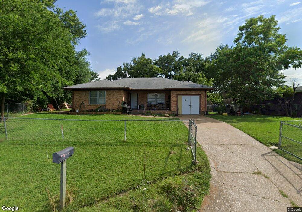
6 Cynthia Dr Denison, TX 75020
Estimated Value: $175,138 - $194,000
3
Beds
2
Baths
1,479
Sq Ft
$125/Sq Ft
Est. Value
About This Home
This home is located at 6 Cynthia Dr, Denison, TX 75020 and is currently estimated at $184,569, approximately $124 per square foot. 6 Cynthia Dr is a home located in Grayson County with nearby schools including Terrell Elementary School, Scott Middle School, and Denison High School.
Ownership History
Date
Name
Owned For
Owner Type
Purchase Details
Closed on
Mar 1, 2010
Sold by
Brown Steven J and Brown Jessica L
Bought by
Scott Tracy L
Current Estimated Value
Home Financials for this Owner
Home Financials are based on the most recent Mortgage that was taken out on this home.
Original Mortgage
$54,003
Outstanding Balance
$35,792
Interest Rate
4.98%
Mortgage Type
FHA
Estimated Equity
$148,777
Create a Home Valuation Report for This Property
The Home Valuation Report is an in-depth analysis detailing your home's value as well as a comparison with similar homes in the area
Home Values in the Area
Average Home Value in this Area
Purchase History
| Date | Buyer | Sale Price | Title Company |
|---|---|---|---|
| Scott Tracy L | -- | Chapin Title Co Inc |
Source: Public Records
Mortgage History
| Date | Status | Borrower | Loan Amount |
|---|---|---|---|
| Open | Scott Tracy L | $54,003 |
Source: Public Records
Tax History Compared to Growth
Tax History
| Year | Tax Paid | Tax Assessment Tax Assessment Total Assessment is a certain percentage of the fair market value that is determined by local assessors to be the total taxable value of land and additions on the property. | Land | Improvement |
|---|---|---|---|---|
| 2025 | $1,074 | $103,041 | -- | -- |
| 2024 | $2,176 | $93,674 | $0 | $0 |
| 2023 | $876 | $85,158 | $0 | $0 |
| 2022 | $1,839 | $77,416 | $0 | $0 |
| 2021 | $1,775 | $77,914 | $21,240 | $56,674 |
| 2020 | $1,688 | $63,980 | $7,106 | $56,874 |
| 2019 | $1,654 | $60,103 | $7,106 | $52,997 |
| 2018 | $1,619 | $60,826 | $7,106 | $53,720 |
| 2017 | $1,484 | $57,922 | $2,472 | $55,450 |
| 2016 | $1,342 | $47,981 | $2,400 | $45,581 |
| 2015 | $868 | $44,666 | $2,400 | $42,266 |
| 2014 | $1,188 | $51,322 | $2,400 | $48,922 |
Source: Public Records
Map
Nearby Homes
- 46 Vaughn Dr
- 40 Vaughn Dr
- 13 Geraldine Ln
- TBD Geraldine Ln
- 17 Geraldine Ln
- 14 Geraldine Ln
- 25 W Parnell St
- 531 W Brewster St
- 503 Martin Luther King St
- 401-403 W Elm St
- 415 W Elm St Unit 415-417
- 723 W Parnell St
- 720 W Parnell St
- 526 W Elm St
- 409 W Johnson St
- 425 W Johnson St
- 610 W Elm St
- 930 N Mirick Ave
- 910 N Houston Ave
- 315 W Walker St