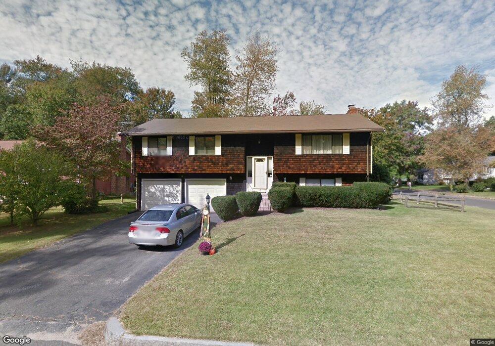
6 Danaher Cir Springfield, MA 01118
Sixteen Acres NeighborhoodEstimated Value: $318,000 - $378,983
3
Beds
3
Baths
1,924
Sq Ft
$183/Sq Ft
Est. Value
About This Home
This home is located at 6 Danaher Cir, Springfield, MA 01118 and is currently estimated at $351,746, approximately $182 per square foot. 6 Danaher Cir is a home located in Hampden County with nearby schools including Arthur T Talmadge Elementary School, M Marcus Kiley Middle, and Springfield High School of Science and Technology.
Ownership History
Date
Name
Owned For
Owner Type
Purchase Details
Closed on
Sep 23, 2003
Sold by
Shaver Marie A
Bought by
Carter Angela M and Carter Rodney
Current Estimated Value
Home Financials for this Owner
Home Financials are based on the most recent Mortgage that was taken out on this home.
Original Mortgage
$109,000
Outstanding Balance
$50,808
Interest Rate
6.31%
Mortgage Type
Purchase Money Mortgage
Estimated Equity
$300,938
Purchase Details
Closed on
Nov 30, 1987
Sold by
Henry Keith C
Bought by
Shaver Robert L
Home Financials for this Owner
Home Financials are based on the most recent Mortgage that was taken out on this home.
Original Mortgage
$120,000
Interest Rate
11.59%
Mortgage Type
Purchase Money Mortgage
Create a Home Valuation Report for This Property
The Home Valuation Report is an in-depth analysis detailing your home's value as well as a comparison with similar homes in the area
Home Values in the Area
Average Home Value in this Area
Purchase History
| Date | Buyer | Sale Price | Title Company |
|---|---|---|---|
| Carter Angela M | $125,000 | -- | |
| Shaver Robert L | $140,000 | -- |
Source: Public Records
Mortgage History
| Date | Status | Borrower | Loan Amount |
|---|---|---|---|
| Open | Carter Angela M | $109,000 | |
| Previous Owner | Shaver Robert L | $15,000 | |
| Previous Owner | Shaver Robert L | $120,000 |
Source: Public Records
Tax History
| Year | Tax Paid | Tax Assessment Tax Assessment Total Assessment is a certain percentage of the fair market value that is determined by local assessors to be the total taxable value of land and additions on the property. | Land | Improvement |
|---|---|---|---|---|
| 2025 | $4,958 | $316,200 | $57,100 | $259,100 |
| 2024 | $4,776 | $297,400 | $57,100 | $240,300 |
| 2023 | $4,131 | $242,300 | $54,300 | $188,000 |
| 2022 | $3,952 | $210,000 | $54,300 | $155,700 |
| 2021 | $4,016 | $212,500 | $49,400 | $163,100 |
| 2020 | $3,996 | $204,600 | $49,400 | $155,200 |
| 2019 | $3,777 | $191,900 | $49,400 | $142,500 |
| 2018 | $3,446 | $175,100 | $49,400 | $125,700 |
| 2017 | $3,385 | $172,200 | $49,400 | $122,800 |
| 2016 | $3,134 | $159,400 | $49,400 | $110,000 |
| 2015 | $3,198 | $162,600 | $49,400 | $113,200 |
Source: Public Records
Map
Nearby Homes
- 25 Laurelwood Ln
- 41 Hillside Dr
- 24 Wands St
- 86 Wildwood Ave
- 85 Talmadge Dr
- 81 W Crystal Brook Dr
- 86 Talmadge Dr
- 1962 Allen St
- 17 Pebble Mill Rd
- 17 Skyridge Ln
- 49 Corcoran Blvd
- 55 Allen St
- 206 Treetop Ave
- 0 Apple Blossom Ln
- 125 Manor Ct Unit 125
- 19 Manor Ct Unit 19
- 101 Regal St
- 119 Acrebrook Rd
- 647 Plumtree Rd
- 55 Old Farm Rd
- 12 Danaher Cir
- 50 Ramblewood Dr
- 5 Danaher Cir
- 20 Danaher Cir
- 55 Ramblewood Dr
- 15 Trail Cir
- 61 Ramblewood Dr
- 5 Trail Cir
- 45 Ramblewood Dr
- 15 Danaher Cir
- 69 Ramblewood Dr
- 39 Ramblewood Dr
- 80 Ramblewood Dr
- 77 Ramblewood Dr
- 25 Danaher Cir
- 31 Ramblewood Dr
- 6 Cluster Cir
- 83 Ramblewood Dr
- 29 Danaher Cir
- 12 Cluster Cir
Your Personal Tour Guide
Ask me questions while you tour the home.