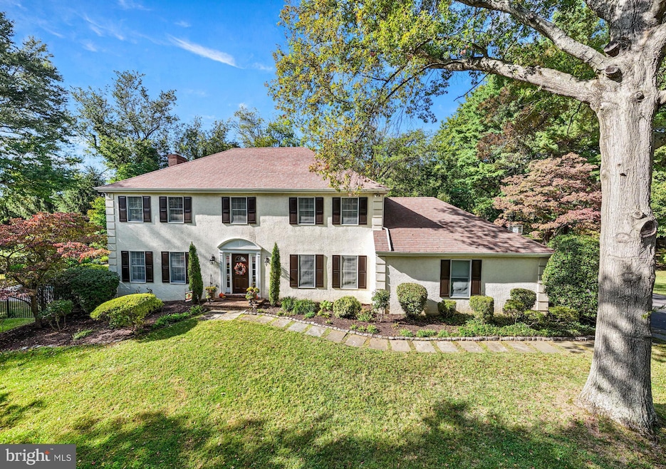
6 Duncan Ln Bryn Mawr, PA 19010
Estimated payment $7,780/month
Highlights
- Lap Pool
- Colonial Architecture
- Vaulted Ceiling
- Ithan Elementary School Rated A+
- Deck
- Mud Room
About This Home
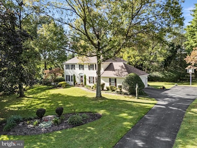
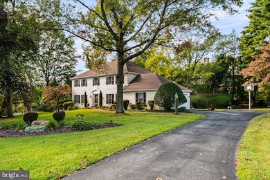
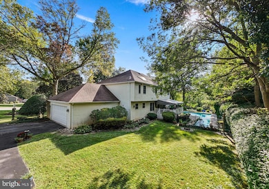
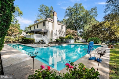
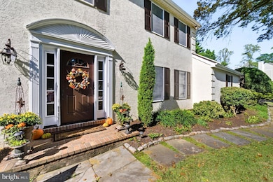
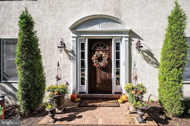
Welcome to this beautiful French Colonial home offering 4 bedrooms and 3.5 baths with over 3,600 square feet of living space situated on 1.26 acres. Tucked away on a quiet cul-de-sac in a highly sought after Bryn Mawr neighborhood, you'll be part of the top-ranked Radnor School District. This home is sure to catch your eye with its stunning curb appeal, highlighted by professionally landscaped grounds featuring trees, manicured gardens, and a sparkling in-ground pool. As you approach, a charming flagstone walkway with Belgium block border leads you to the entrance and into the welcoming foyer. Inside is filled with natural light and features a modern, neutral color palette throughout. The home is designed for easy everyday living and great for entertaining, with a layout that smoothly connects indoor and outdoor areas. On either side of the center Foyer, you'll find the elegant Living Room and formal Dining Room both with hardwood flooring, crown molding, and picturesque views of front yard. These spaces are complemented by a powder room and coat closet. At the heart of the home, the Kitchen and Family Room embrace an open-concept design, featuring ceramic tile flooring and showcasing beautiful views of the private backyard. A chef’s delight, the renovated kitchen features stainless steel appliances, granite countertops, a tile backsplash, and custom wood cabinetry with glass front accents, offering plentiful storage. A 7+ foot center island with seating for 4, a double-door pantry, and recessed lighting enhance the space, while an adjacent Mudroom area within the oversized 2-car garage adds practicality. The Breakfast area flows into the Family Room, with wood-beamed ceiling and a rustic, floor-to-ceiling stone fireplace with custom-built-ins and French doors. Step out onto the spacious, maintenance-free Trex deck with custom awning, which overlooks the serene rear yard and pool. Your private backyard retreat includes a large, rectangular pool with a royal blue mosaic border, diving board, spa, bonus regulation lap lane, all surrounded by elegant black wrought iron fencing. Accented with beautiful hard scaping garden walls with perennial plantings, the paver patio is the perfect spot for grilling & dining by the pool plus grassy areas to play. In addition to the expanded driveway space for playing basketball and riding bikes, there are multiple yard spaces for playing sports and adding a firepit, gazebo, or swing set. Upstairs, the primary suite features a spacious bedroom, an impressive walk-in closet with built-in shelving and drawers illuminated by natural light, a second walk-in closet (with access to a large floored attic for storage or possibly converted to additional living space), a double door closet, custom wood blinds, and ceiling fan. Spa-like en-suite bath offers dual-sink vanity, jetted tub, vaulted ceiling with skylight, tiled floors, a tiled oversized shower with glass doors, and water closet. 3 sunny bedrooms, each with plush carpeting, ceiling fans, generous closet space, and custom wood blinds, share a full Hall Bath. One bedroom has direct bath access, making it perfect for guests or as a "princess suite." Updated Hall Bath includes tiled floors, a tiled tub & shower, a linen closet, window, recessed lighting, and a conveniently located laundry closet. Finished Lower Level provides almost 1,100 sq ft of versatile living space with Full Bath plus built-in countertop – ideal for a Home Office, homework zone, or arts & crafts space. Additionally, there is ample room for rec/game/movie room, exercise/playroom, or au-pair suite complete with custom closets and storage. Located near major commuter routes, train station, private schools, and the vibrant Bryn Mawr shops & restaurants. , this home and property offer the best of Main Line living. Don’t miss the opportunity to make this home yours. Schedule your visit today!
Listing Agent
(610) 757-8873 wendy.sharkey@compass.com Compass RE License #RS324398 Listed on: 10/02/2025

Home Details
Home Type
- Single Family
Est. Annual Taxes
- $14,294
Year Built
- Built in 1984
Lot Details
- 1.26 Acre Lot
- See Agent Remarks - sale includes additional adjacent parcel #36-05-03026-09
- Property is in excellent condition
- Property is zoned R-10
Parking
- 2 Car Direct Access Garage
- Oversized Parking
- Side Facing Garage
- Garage Door Opener
- Driveway
- On-Street Parking
Home Design
- Colonial Architecture
- French Architecture
- Stucco
Interior Spaces
- Property has 3 Levels
- Crown Molding
- Vaulted Ceiling
- Recessed Lighting
- Wood Burning Fireplace
- Fireplace Mantel
- Mud Room
- Breakfast Area or Nook
- Laundry on upper level
- Finished Basement
Bedrooms and Bathrooms
- 4 Bedrooms
Accessible Home Design
- Ramp on the main level
Pool
- Lap Pool
- In Ground Pool
Outdoor Features
- Deck
- Patio
Schools
- Ithan Elementary School
- Radnor Middle School
- Radnor High School
Utilities
- Central Air
- Heat Pump System
- Electric Water Heater
Community Details
- No Home Owners Association
Listing and Financial Details
- Assessor Parcel Number 36-05-03026-03
Map
Home Values in the Area
Average Home Value in this Area
Tax History
| Year | Tax Paid | Tax Assessment Tax Assessment Total Assessment is a certain percentage of the fair market value that is determined by local assessors to be the total taxable value of land and additions on the property. | Land | Improvement |
|---|---|---|---|---|
| 2025 | $13,074 | $646,640 | $226,900 | $419,740 |
| 2024 | $13,074 | $646,640 | $226,900 | $419,740 |
| 2023 | $12,556 | $646,640 | $226,900 | $419,740 |
| 2022 | $12,419 | $646,640 | $226,900 | $419,740 |
| 2021 | $19,948 | $646,640 | $226,900 | $419,740 |
| 2020 | $12,513 | $359,710 | $128,990 | $230,720 |
| 2019 | $12,160 | $359,710 | $128,990 | $230,720 |
| 2018 | $11,922 | $359,710 | $0 | $0 |
| 2017 | $11,672 | $359,710 | $0 | $0 |
| 2016 | $1,974 | $359,710 | $0 | $0 |
| 2015 | $1,974 | $359,710 | $0 | $0 |
| 2014 | $1,974 | $359,710 | $0 | $0 |
Property History
| Date | Event | Price | List to Sale | Price per Sq Ft |
|---|---|---|---|---|
| 10/06/2025 10/06/25 | Pending | -- | -- | -- |
| 10/02/2025 10/02/25 | For Sale | $1,250,000 | -- | $341 / Sq Ft |
Purchase History
| Date | Type | Sale Price | Title Company |
|---|---|---|---|
| Deed | $550,000 | -- | |
| Trustee Deed | $382,500 | Commonwealth Land Title Ins |
Mortgage History
| Date | Status | Loan Amount | Loan Type |
|---|---|---|---|
| Previous Owner | $400,000 | Stand Alone First | |
| Previous Owner | $306,000 | Purchase Money Mortgage |
Source: Bright MLS
MLS Number: PADE2101172
APN: 36-05-03026-03
Disclaimer: Certain information contained herein is derived from information provided by parties other than Homes.com. All information provided is deemed reliable, but is not guaranteed to be accurate and should be independently verified.
![]() The data relating to real estate for sale on this website appears in part through the BRIGHT Internet Data Exchange program, a voluntary cooperative exchange of property listing data between licensed real estate brokerage firms, and is provided by BRIGHT through a licensing agreement.
The data relating to real estate for sale on this website appears in part through the BRIGHT Internet Data Exchange program, a voluntary cooperative exchange of property listing data between licensed real estate brokerage firms, and is provided by BRIGHT through a licensing agreement.
Listing information is from various brokers who participate in the Bright MLS IDX program and not all listings may be visible on the site.
The property information being provided on or through the website is for the personal, non-commercial use of consumers and such information may not be used for any purpose other than to identify prospective properties consumers may be interested in purchasing.
Some properties which appear for sale on the website may no longer be available because they are for instance, under contract, sold or are no longer being offered for sale.
Property information displayed is deemed reliable but is not guaranteed.
Copyright 2025 Bright MLS, Inc.
- 821 Coopertown Rd
- 53 Parkridge Dr
- 62 Parkridge Dr Unit 62
- 67 Parkridge Dr
- 202 Summit Dr Unit B
- 103 Summit Dr Unit B
- 306 Summit Dr
- 390 S Bryn Mawr Ave
- 145 Landover Rd
- 501 College Ave
- 633 Foxfields Rd
- 173 Clemson Rd
- 215 Cornell Dr
- 258 Lee Cir
- 408 Barbara Ln Unit B
- 4105 Parkview Dr
- 741 County Line Rd
- 560 S Bryn Mawr Ave
- 133 Quaker Ln
- 71 S Merion Ave