Estimated Value: $887,709 - $1,133,000
Studio
--
Bath
2,863
Sq Ft
$362/Sq Ft
Est. Value
About This Home
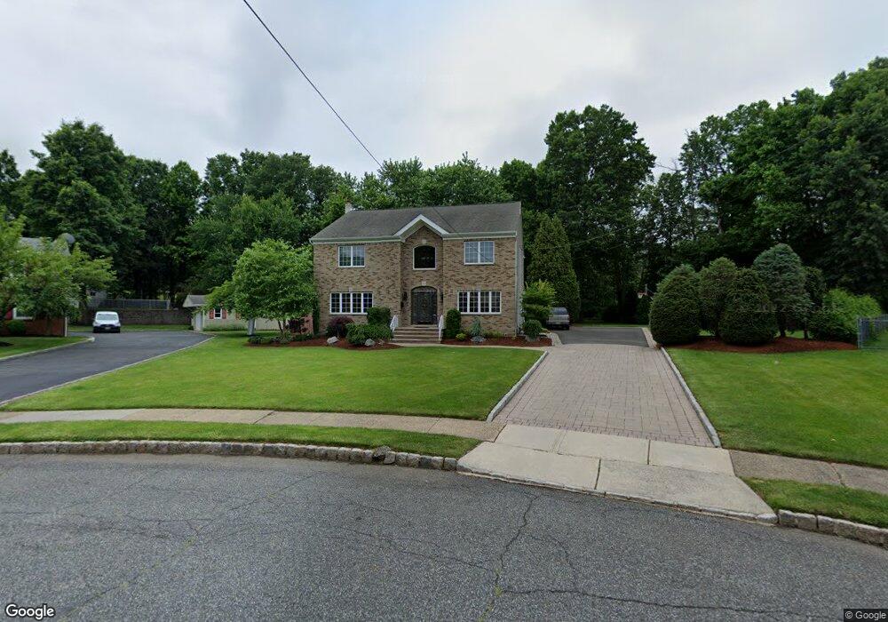
This home is located at 6 Grouse Ln, Clark, NJ 07066 and is currently estimated at $1,035,677, approximately $361 per square foot. 6 Grouse Ln is a home located in Union County with nearby schools including Frank K. Hehnly Elementary School, Carl H. Kumpf Middle School, and Arthur L. Johnson High School.
Ownership History
Date
Name
Owned For
Owner Type
Purchase Details
Closed on
Aug 20, 2004
Sold by
Bove Pasquale
Bought by
Midrano Kenneth and Midrano Maria
Current Estimated Value
Home Financials for this Owner
Home Financials are based on the most recent Mortgage that was taken out on this home.
Original Mortgage
$250,000
Outstanding Balance
$124,136
Interest Rate
6.02%
Estimated Equity
$911,541
Create a Home Valuation Report for This Property
The Home Valuation Report is an in-depth analysis detailing your home's value as well as a comparison with similar homes in the area
Home Values in the Area
Average Home Value in this Area
Purchase History
| Date | Buyer | Sale Price | Title Company |
|---|---|---|---|
| Midrano Kenneth | $585,000 | -- |
Source: Public Records
Mortgage History
| Date | Status | Borrower | Loan Amount |
|---|---|---|---|
| Open | Midrano Kenneth | $250,000 |
Source: Public Records
Tax History
| Year | Tax Paid | Tax Assessment Tax Assessment Total Assessment is a certain percentage of the fair market value that is determined by local assessors to be the total taxable value of land and additions on the property. | Land | Improvement |
|---|---|---|---|---|
| 2025 | $13,204 | $596,400 | $176,300 | $420,100 |
| 2024 | $13,007 | $596,400 | $176,300 | $420,100 |
| 2023 | $13,007 | $596,400 | $176,300 | $420,100 |
| 2022 | $12,632 | $596,400 | $176,300 | $420,100 |
| 2021 | $14,873 | $167,300 | $48,100 | $119,200 |
| 2020 | $14,630 | $167,300 | $48,100 | $119,200 |
| 2019 | $14,483 | $167,300 | $48,100 | $119,200 |
| 2018 | $14,309 | $167,300 | $48,100 | $119,200 |
| 2017 | $14,080 | $167,300 | $48,100 | $119,200 |
| 2016 | $13,561 | $167,300 | $48,100 | $119,200 |
| 2015 | $13,424 | $167,300 | $48,100 | $119,200 |
| 2014 | $13,141 | $167,300 | $48,100 | $119,200 |
Source: Public Records
Map
Nearby Homes
- 17 Rolling Hill Way
- 1138 William V Young Dr
- 27 Stemmer Dr
- 814 Falesky St
- 26 Linda Ave
- 24 Frederick Ave
- 116 Arthur Ave
- 20 Joanna Place
- 20 Alastair Place
- 78 Patricia Ave
- 1044 Madison Hill Rd
- 793 Garden St
- 279 Madison Hill Rd
- 675 Raritan Rd Unit 12
- 272 Westfield Ave
- 150 Carolyn Ave
- 127 Dukes Rd
- 157 Westfield Ave
- 15 E Walnut St
- 237 Carolyn Ave
- 4 Grouse Ln
- 8 Grouse Ln
- 2 Grouse Ln
- 7 Grouse Ln
- 10 Grouse Ln
- 18 Rolling Hill Way
- 12 Rolling Hill Way
- 7 Hartman Ct
- 1 Partridge Run
- 9 Hartman Ct
- 3 Partridge Run
- 15 Rolling Hill Way
- 13 Rolling Hill Way
- 10 Rolling Hill Way
- 11 Rolling Hill Way
- 19 Rolling Hill Way
- 5 Hartman Ct
- 21 Rolling Hill Way
- 8 Rolling Hill Way
- 9 Rolling Hill Way
Your Personal Tour Guide
Ask me questions while you tour the home.