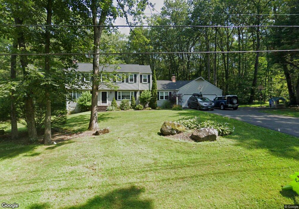
6 Katherine Ln Simsbury, CT 06070
Estimated Value: $599,000 - $654,000
4
Beds
3
Baths
2,270
Sq Ft
$278/Sq Ft
Est. Value
About This Home
This home is located at 6 Katherine Ln, Simsbury, CT 06070 and is currently estimated at $630,712, approximately $277 per square foot. 6 Katherine Ln is a home located in Hartford County with nearby schools including Squadron Line School, Henry James Memorial School, and Simsbury High School.
Ownership History
Date
Name
Owned For
Owner Type
Purchase Details
Closed on
Feb 23, 2024
Sold by
Crisco Jason and Crisco Laura
Bought by
Laura B Crisco 2024 Ret and Crisco
Current Estimated Value
Purchase Details
Closed on
May 30, 2017
Sold by
Sperger Mary D
Bought by
Crisco Jason and Crisco Laura
Home Financials for this Owner
Home Financials are based on the most recent Mortgage that was taken out on this home.
Original Mortgage
$316,000
Interest Rate
3.34%
Mortgage Type
New Conventional
Purchase Details
Closed on
Sep 27, 1996
Sold by
Barber Robert O and Barber Rosa E
Bought by
Colon Anthony J and Colon Sondra
Create a Home Valuation Report for This Property
The Home Valuation Report is an in-depth analysis detailing your home's value as well as a comparison with similar homes in the area
Home Values in the Area
Average Home Value in this Area
Purchase History
| Date | Buyer | Sale Price | Title Company |
|---|---|---|---|
| Laura B Crisco 2024 Ret | -- | None Available | |
| Crisco Jason | $400,000 | -- | |
| Colon Anthony J | $133,000 | -- |
Source: Public Records
Mortgage History
| Date | Status | Borrower | Loan Amount |
|---|---|---|---|
| Previous Owner | Colon Anthony J | $316,000 | |
| Previous Owner | Colon Anthony J | $212,630 |
Source: Public Records
Tax History Compared to Growth
Tax History
| Year | Tax Paid | Tax Assessment Tax Assessment Total Assessment is a certain percentage of the fair market value that is determined by local assessors to be the total taxable value of land and additions on the property. | Land | Improvement |
|---|---|---|---|---|
| 2025 | $11,083 | $324,450 | $101,710 | $222,740 |
| 2024 | $10,807 | $324,450 | $101,710 | $222,740 |
| 2023 | $10,324 | $324,450 | $101,710 | $222,740 |
| 2022 | $9,965 | $257,950 | $108,990 | $148,960 |
| 2021 | $9,965 | $257,950 | $108,990 | $148,960 |
| 2020 | $9,567 | $257,950 | $108,990 | $148,960 |
| 2019 | $9,627 | $257,950 | $108,990 | $148,960 |
| 2018 | $9,696 | $257,950 | $108,990 | $148,960 |
| 2017 | $9,310 | $240,200 | $108,980 | $131,220 |
| 2016 | $8,916 | $240,200 | $108,980 | $131,220 |
| 2015 | $8,916 | $240,200 | $108,980 | $131,220 |
| 2014 | $8,921 | $240,200 | $108,980 | $131,220 |
Source: Public Records
Map
Nearby Homes
- 324 Firetown Rd
- 5 Anja Dr
- 303 Firetown Rd
- 12 Gretel Ln
- 16 Berkshire Way
- 21 Berkshire Way
- 40 Holcomb St
- 35 Haven Dr
- 16 Lionel Dr
- 230 Firetown Rd
- 15 Knollwood Cir
- 33 Whitman Dr
- 26 Winterset Ln
- 247 Old Farms Rd
- 55 Musket Trail
- 45 Hoskins Rd
- 27 Brettonwood Dr Unit 27
- 49 Brettonwood Dr Unit 49
- 14 Brettonwood Dr
- 9 Kerr Farm Rd
- 3 Katherine Ln
- 4 Katherine Ln
- 5 Katherine Ln
- 1 Katherine Ln
- 8 Katherine Ln
- 2 Katherine Ln
- 7 Katherine Ln
- 37 Clifdon Dr
- 15 Scarborough Rd
- 10 Katherine Ln
- 26 Clifdon Dr
- 31 Clifdon Dr
- 39 Clifdon Dr
- 28 Clifdon Dr
- 14 Scarborough Rd
- 24 Clifdon Dr
- 41 Clifdon Dr
- 32 Clifdon Dr
- 11 Scarborough Rd
- 27 Clifdon Dr