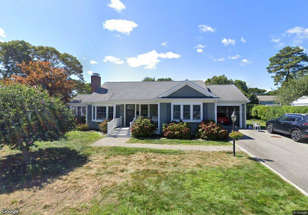
6 Lewis Ln Harwich Port, MA 02646
Harwich Port NeighborhoodEstimated Value: $1,032,000 - $1,267,000
3
Beds
2
Baths
1,384
Sq Ft
$821/Sq Ft
Est. Value
About This Home
This home is located at 6 Lewis Ln, Harwich Port, MA 02646 and is currently estimated at $1,136,389, approximately $821 per square foot. 6 Lewis Ln is a home located in Barnstable County with nearby schools including Harwich Elementary School, Chatham Elementary School, and Monomoy Regional Middle School.
Ownership History
Date
Name
Owned For
Owner Type
Purchase Details
Closed on
Mar 26, 2013
Sold by
Mondani Peter and Mondani Donna
Bought by
Peter J Mondani Sr Lt and Mondani Peter J
Current Estimated Value
Purchase Details
Closed on
Sep 17, 2009
Sold by
Lordan Helen Louise
Bought by
Lordan Mary Lou
Purchase Details
Closed on
Aug 7, 2006
Sold by
Indesign Llc
Bought by
Proaccino John W
Create a Home Valuation Report for This Property
The Home Valuation Report is an in-depth analysis detailing your home's value as well as a comparison with similar homes in the area
Home Values in the Area
Average Home Value in this Area
Purchase History
| Date | Buyer | Sale Price | Title Company |
|---|---|---|---|
| Peter J Mondani Sr Lt | -- | -- | |
| Lordan Mary Lou | -- | -- | |
| Proaccino John W | -- | -- |
Source: Public Records
Tax History Compared to Growth
Tax History
| Year | Tax Paid | Tax Assessment Tax Assessment Total Assessment is a certain percentage of the fair market value that is determined by local assessors to be the total taxable value of land and additions on the property. | Land | Improvement |
|---|---|---|---|---|
| 2025 | $5,667 | $958,800 | $434,000 | $524,800 |
| 2024 | $5,491 | $910,600 | $409,500 | $501,100 |
| 2023 | $5,297 | $797,800 | $372,300 | $425,500 |
| 2022 | $5,282 | $651,300 | $323,700 | $327,600 |
| 2021 | $5,023 | $584,100 | $294,300 | $289,800 |
| 2020 | $4,876 | $558,500 | $273,900 | $284,600 |
| 2019 | $4,555 | $525,400 | $260,000 | $265,400 |
| 2018 | $4,588 | $506,200 | $236,400 | $269,800 |
| 2017 | $4,240 | $472,700 | $220,100 | $252,600 |
| 2016 | $4,187 | $461,600 | $220,100 | $241,500 |
| 2015 | $4,154 | $463,100 | $215,700 | $247,400 |
| 2014 | $3,967 | $452,300 | $209,300 | $243,000 |
Source: Public Records
Map
Nearby Homes
- 15 Pleasant St Unit W24
- 515 Route 28
- 515 Massachusetts 28
- 9 Jason Ln
- 23 Zylpha Rd
- 53 Freeman St
- 405 Lower County Rd Unit 21
- 405 Lower County Rd Unit 23
- 8 Wyndemere Bluffs Rd
- 292 Massachusetts 28 Unit 1
- 292 Massachusetts 28 Unit 7
- 135 Sisson Rd
- 16 Mirasol Ln
- 297 Massachusetts 28
- 297 Massachusetts 28 Unit 1
- 7 Dunes Rd
- 292 Route 28 Unit 7
- 15 Shannon Rd
- 303 Bank St
- 18 Old Campground
- 10 Lewis Ln
- 10 Lewis Ln Unit 2
- 4 Lewis Ln
- 7 Lewis Ln
- 3 Lewis Ln
- 11 Lewis Ln
- 13 South St
- 12 Lewis Ln
- 21 South St
- 15 Pleasant St Unit E22
- 15 Pleasant St Unit N1
- 15 Pleasant St Unit 24W
- 15 Pleasant St Unit 23W
- 15 Pleasant St Unit 22W
- 15 Pleasant St Unit 21W
- 15 Pleasant St Unit 24S
- 15 Pleasant St Unit 23S
- 15 Pleasant St Unit 22S
- 15 Pleasant St Unit 21S
- 15 Pleasant St Unit 24N