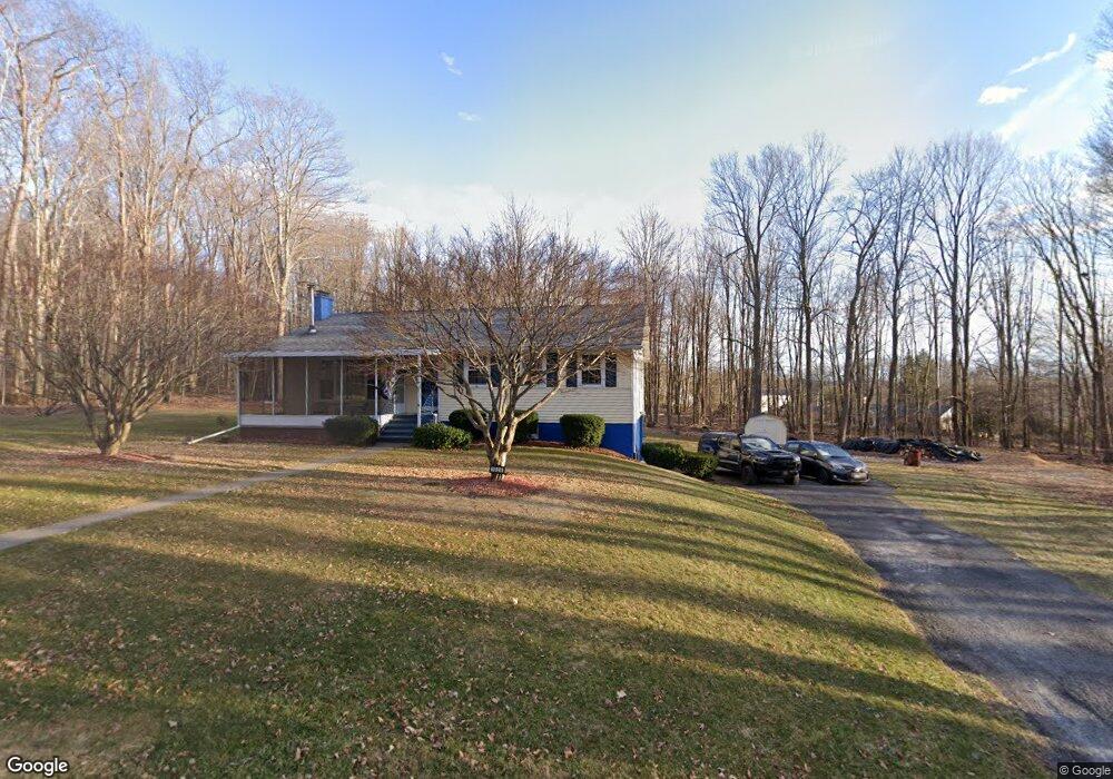
6 Maple St Spring Brook Township, PA 18444
Estimated Value: $125,930 - $288,000
Studio
--
Bath
--
Sq Ft
24,699
Sq Ft
About This Home
This home is located at 6 Maple St, Spring Brook Township, PA 18444 and is currently estimated at $235,233. 6 Maple St is a home located in Lackawanna County with nearby schools including Jefferson El School and North Pocono High School.
Ownership History
Date
Name
Owned For
Owner Type
Purchase Details
Closed on
Sep 16, 2020
Sold by
Flyte Stephen L
Bought by
Vanderlinden William R
Current Estimated Value
Home Financials for this Owner
Home Financials are based on the most recent Mortgage that was taken out on this home.
Original Mortgage
$142,400
Outstanding Balance
$126,136
Interest Rate
2.8%
Mortgage Type
New Conventional
Estimated Equity
$109,097
Purchase Details
Closed on
May 1, 2009
Sold by
Flyte Frederick S and Flyte Jo Anne
Bought by
Flyte Stephen L and Flyte Family Irrevocable Personal Reside
Create a Home Valuation Report for This Property
The Home Valuation Report is an in-depth analysis detailing your home's value as well as a comparison with similar homes in the area
Home Values in the Area
Average Home Value in this Area
Purchase History
| Date | Buyer | Sale Price | Title Company |
|---|---|---|---|
| Vanderlinden William R | $178,000 | Homebuyers Abstract | |
| Flyte Stephen L | -- | None Available |
Source: Public Records
Mortgage History
| Date | Status | Borrower | Loan Amount |
|---|---|---|---|
| Open | Vanderlinden William R | $142,400 |
Source: Public Records
Tax History
| Year | Tax Paid | Tax Assessment Tax Assessment Total Assessment is a certain percentage of the fair market value that is determined by local assessors to be the total taxable value of land and additions on the property. | Land | Improvement |
|---|---|---|---|---|
| 2025 | $3,636 | $13,285 | $1,785 | $11,500 |
| 2024 | $3,053 | $13,285 | $1,785 | $11,500 |
| 2023 | $3,053 | $13,285 | $1,785 | $11,500 |
| 2022 | $2,969 | $13,285 | $1,785 | $11,500 |
| 2021 | $2,924 | $13,285 | $0 | $13,285 |
| 2020 | $2,887 | $13,285 | $0 | $13,285 |
| 2019 | $2,749 | $13,285 | $0 | $13,285 |
| 2018 | $2,705 | $13,285 | $0 | $13,285 |
| 2017 | $2,671 | $13,285 | $0 | $13,285 |
| 2016 | $1,523 | $13,285 | $0 | $0 |
| 2015 | -- | $13,285 | $0 | $0 |
| 2014 | -- | $13,285 | $0 | $0 |
Source: Public Records
Map
Nearby Homes
- 0 Green Briar Dr
- 0 Carl Sunset Ln
- 64 Green Briar Dr
- 52 Woodland Dr
- 316 Ohara Rd T 316 Rd Unit T 316
- 0 Donny Dr
- T 330 L-c Gardner Rd
- 502 Park Ln
- 922 Old Logger Rd
- 42 Davis St
- 304 T Rt 351
- 210 Beechwood Dr
- wl752 N Lake View
- 500 Scranton-Pocono Hwy
- 118 Sunset Rd
- 501 Circle Dr
- 407 Hill St
- 603 Clover Ln
- 708 Pin Oak Place
- 1620 State Route 502
- 1026 Maple St
- 1025 Maple St
- 1019 Maple St
- 1000 Maple St
- 890 State Route 307
- 30 Maple St
- 47 Beech Rd
- Lot 31 41 Birch St
- 880 State Route 307
- 307 Maple St L 32
- 1024 Beech St
- 65 Beech Rd
- 881 State Route 307
- 307 State Route 590
- 876 State Route 307
- 1015 Beech St
- 917 State Route 307
- 1006 Beech St
- 1014 Beech St
- 867 State Route 307
Your Personal Tour Guide
Ask me questions while you tour the home.