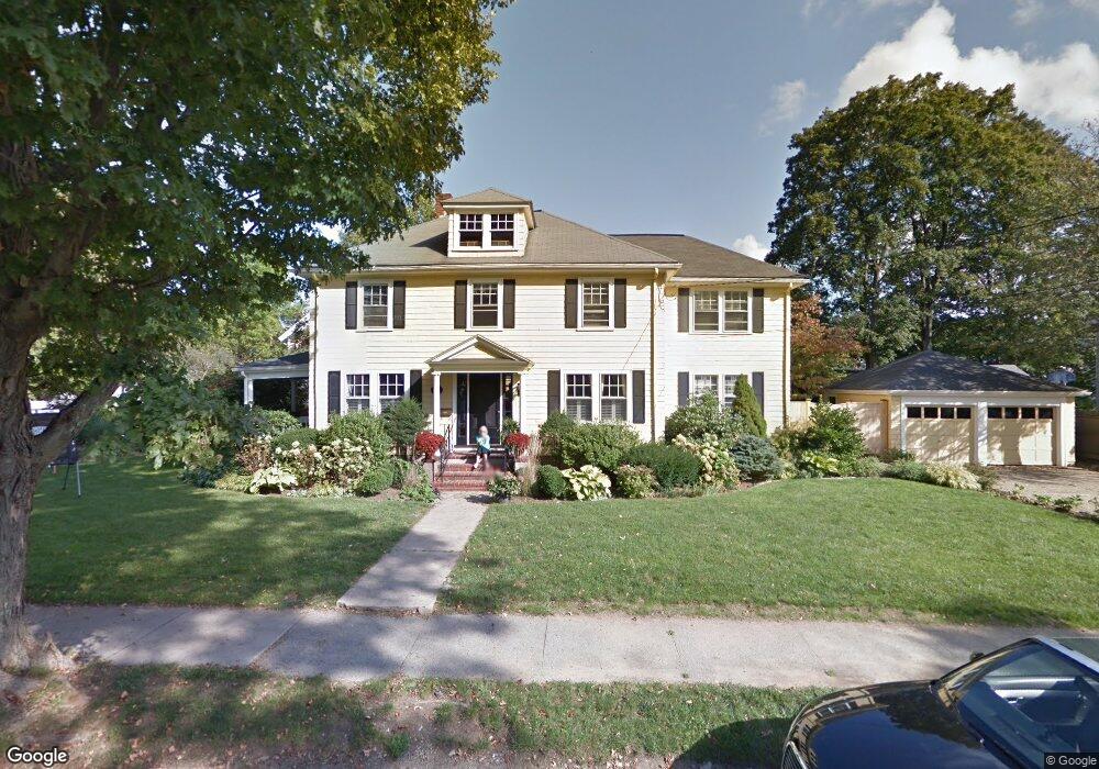
6 Mayo Ave Needham, MA 02492
Estimated Value: $1,423,000 - $1,884,000
4
Beds
3
Baths
1,068
Sq Ft
$1,543/Sq Ft
Est. Value
About This Home
This home is located at 6 Mayo Ave, Needham, MA 02492 and is currently estimated at $1,648,072, approximately $1,543 per square foot. 6 Mayo Ave is a home located in Norfolk County with nearby schools including Broadmeadow Elementary School, High Rock Middle School, and Pollard Middle School.
Ownership History
Date
Name
Owned For
Owner Type
Purchase Details
Closed on
Jul 24, 1997
Sold by
Boecklin Arnold P and Boecklin Mary N
Bought by
Dinatale Richard H and Dinatale Siobhan
Current Estimated Value
Purchase Details
Closed on
Mar 17, 1993
Sold by
Pirone John and Pirone Joan
Bought by
Boecklin Arnold P and Boecklin Mary N
Create a Home Valuation Report for This Property
The Home Valuation Report is an in-depth analysis detailing your home's value as well as a comparison with similar homes in the area
Home Values in the Area
Average Home Value in this Area
Purchase History
| Date | Buyer | Sale Price | Title Company |
|---|---|---|---|
| Dinatale Richard H | $375,000 | -- | |
| Boecklin Arnold P | $330,000 | -- |
Source: Public Records
Mortgage History
| Date | Status | Borrower | Loan Amount |
|---|---|---|---|
| Open | Boecklin Arnold P | $317,000 | |
| Closed | Boecklin Arnold P | $328,000 |
Source: Public Records
Tax History
| Year | Tax Paid | Tax Assessment Tax Assessment Total Assessment is a certain percentage of the fair market value that is determined by local assessors to be the total taxable value of land and additions on the property. | Land | Improvement |
|---|---|---|---|---|
| 2025 | $15,462 | $1,458,700 | $989,600 | $469,100 |
| 2024 | $12,740 | $1,017,600 | $638,500 | $379,100 |
| 2023 | $12,944 | $992,600 | $638,500 | $354,100 |
| 2022 | $12,415 | $928,600 | $585,800 | $342,800 |
| 2021 | $12,100 | $928,600 | $585,800 | $342,800 |
| 2020 | $11,719 | $938,300 | $585,900 | $352,400 |
| 2019 | $10,873 | $877,600 | $532,600 | $345,000 |
| 2018 | $10,426 | $877,600 | $532,600 | $345,000 |
| 2017 | $10,004 | $841,400 | $532,600 | $308,800 |
| 2016 | $9,710 | $841,400 | $532,600 | $308,800 |
| 2015 | $9,499 | $841,400 | $532,600 | $308,800 |
| 2014 | $9,095 | $781,400 | $480,400 | $301,000 |
Source: Public Records
Map
Nearby Homes
- 36 Otis St Unit 36
- 100 Bradford St
- 126 Prince St
- 31 Birds Hill Ave
- 674 Webster St
- 971 Webster St
- 68 Pleasant St Unit 68
- 638 Webster St
- 638 Webster St Unit 638
- 78 Birds Hill Ave
- 1011 Webster St
- 34 Lincoln St Unit 34
- 11 Holmes St
- 1034 Webster St
- 60 Sutton Rd
- 176 Highgate St
- 190 Brookline St
- 103 Aletha Rd
- 19 Oakland Ave Unit 19
- 19 Highland Ct Unit 19
- 706 Great Plain Ave
- 14 Mayo Ave
- 722 Great Plain Ave
- 11 Mayo Ave
- 7 Stevens Rd
- 711 Great Plain Ave
- 17 Stevens Rd
- 20 Mayo Ave
- 20 Mayo Ave
- 79 Woodlawn Ave
- 79 Woodlawn Ave
- 79 Woodlawn Ave Unit 1
- 79 Woodlawn Ave
- 79 Woodlawn Ave Unit 79
- 13 Mayo Ave
- 732 Great Plain Ave
- 719 Great Plain Ave
- 719 Great Plain Ave Unit 1
- 19 Mayo Ave
- 24 Mayo Ave
Your Personal Tour Guide
Ask me questions while you tour the home.