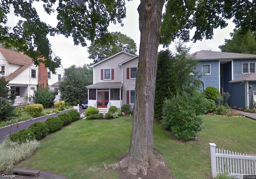
6 Meadow Dr Cos Cob, CT 06807
Estimated Value: $1,494,693 - $1,662,000
3
Beds
3
Baths
1,784
Sq Ft
$894/Sq Ft
Est. Value
About This Home
This home is located at 6 Meadow Dr, Cos Cob, CT 06807 and is currently estimated at $1,595,423, approximately $894 per square foot. 6 Meadow Dr is a home with nearby schools including Cos Cob School, Central Middle School, and Greenwich High School.
Ownership History
Date
Name
Owned For
Owner Type
Purchase Details
Closed on
Jan 3, 2023
Sold by
Wardell David S and Wardell Marie V
Bought by
Marie V Wardell Ret
Current Estimated Value
Purchase Details
Closed on
Nov 2, 2017
Sold by
Wardell David and Wardell Marie
Bought by
Wardell David and Wardell Marie
Purchase Details
Closed on
Apr 29, 1994
Sold by
Larsen Wilhelm N Est
Bought by
Wardell David and Wardell Marie V
Create a Home Valuation Report for This Property
The Home Valuation Report is an in-depth analysis detailing your home's value as well as a comparison with similar homes in the area
Home Values in the Area
Average Home Value in this Area
Purchase History
| Date | Buyer | Sale Price | Title Company |
|---|---|---|---|
| Marie V Wardell Ret | -- | None Available | |
| Wardell David | -- | -- | |
| Wardell David | $127,000 | -- |
Source: Public Records
Mortgage History
| Date | Status | Borrower | Loan Amount |
|---|---|---|---|
| Previous Owner | Wardell David | $245,500 | |
| Previous Owner | Wardell David | $260,000 | |
| Previous Owner | Wardell David | $500,000 |
Source: Public Records
Tax History Compared to Growth
Tax History
| Year | Tax Paid | Tax Assessment Tax Assessment Total Assessment is a certain percentage of the fair market value that is determined by local assessors to be the total taxable value of land and additions on the property. | Land | Improvement |
|---|---|---|---|---|
| 2025 | $7,638 | $618,030 | $431,340 | $186,690 |
| 2024 | $7,377 | $618,030 | $431,340 | $186,690 |
| 2023 | $7,191 | $618,030 | $431,340 | $186,690 |
| 2022 | $7,126 | $618,030 | $431,340 | $186,690 |
| 2021 | $6,790 | $563,920 | $360,080 | $203,840 |
| 2020 | $6,778 | $563,920 | $360,080 | $203,840 |
| 2019 | $6,846 | $563,920 | $360,080 | $203,840 |
| 2018 | $6,694 | $563,920 | $360,080 | $203,840 |
| 2017 | $6,420 | $534,170 | $360,010 | $174,160 |
| 2016 | $6,319 | $534,170 | $360,010 | $174,160 |
| 2015 | $6,487 | $543,970 | $352,660 | $191,310 |
| 2014 | $6,324 | $543,970 | $352,660 | $191,310 |
Source: Public Records
Map
Nearby Homes
- 88 Valleywood Rd
- 67 Cos Cob Ave
- 24 Harold St Unit E
- 24 Valley Rd
- 41 Valley Rd
- 47 Valley Rd Unit B3
- 3 Relay Ct
- 7 Stanwich Rd
- 3 Finney Knoll Ln
- 7 River Rd Unit Boat Slip A-2
- 7 River Rd Unit Boat Slip D-14
- 15 River Rd Unit 210
- 151 Old Church Rd
- 48 Meyer Place
- 32 Meyer Place
- 1 Old Church Rd Unit 2
- 16 Martin Dale N
- 11 Perna Ln
- 636 Steamboat Rd Unit 3 A,B & E
- 37 Miltiades Ave